Category Archives: Stuff

Stuff that is happening in Newburyport, MA, matter, material, articles, activities of a specified or indeterminate kind that is being referred to, indicated, or implied.

Three Years Working on the Interactive Newburyport History Map

Things I’ve learned over the last 3 years working on the Newburyport Interactive History Map – Keeping the Story Alive.

Bossy Gillis, the conflict between the wealthy and the working class

I started the interactive history map 3 years ago in 2019 because the new folks in town didn’t know the basic stories, like Bossy Gillis’s Gas Station on the corner of State and High Streets, that is a story of the class warfare between the wealthy people along the Ridge and the rest of the city, working class folks. That dynamic in 2022 has changed.

Newburyport History Map

Newburyport History Map

The ebb and flow of Newburyport’s well being

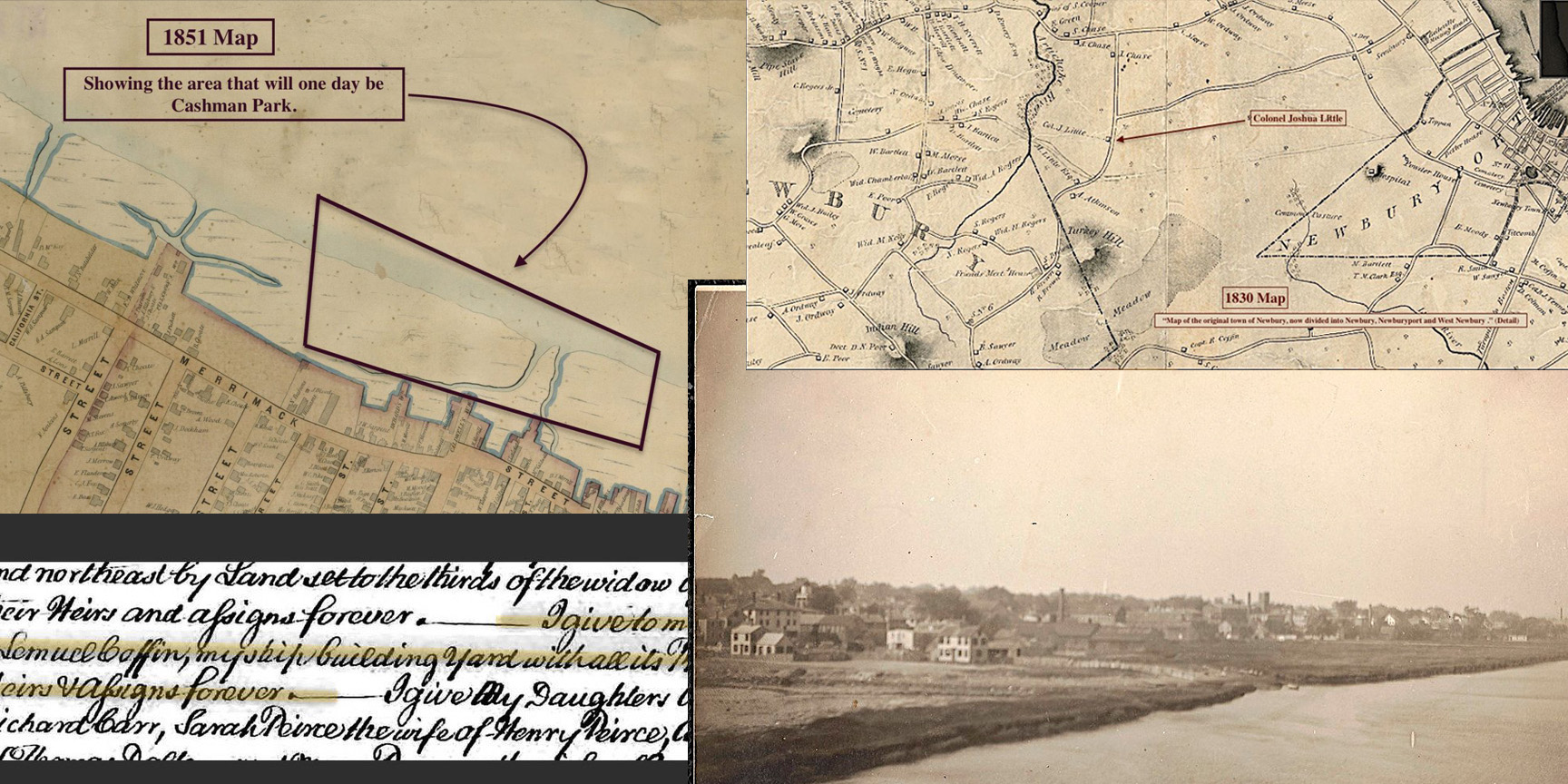
The story of Ferry Wharf that tells the ebb and flow of Newburyport’ success, decline and renewal, from the clipper ships and wealthy merchants, to the filling in of the wharfs near Market Square and the arrival the railroad and coal, to the decline and revival during Urban Renewal.

The story of Cashman Park, which was once just marsh and water, that became an eyesore. Of a second generation immigrant in Newburyport, Michael Cashman, who through hard work and smarts became one of the richest coal and oil dealers in Essex County. He had come up with a vision for the park in 1912, worked quietly for a decade and when he decided to serve his community and became mayor, he made Cashman Park a reality ten years later, a park that has enriched people’s lives for generations.

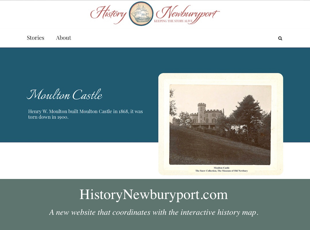
Henry Moulton who came to town in 1855, built himself a castle, wanted to build a whole community in the North End of the City, Moutonville, named after himself, and through bad luck, maybe hubris, maybe bad business, everything he built has faded from the landscape.

The story of Turkey Hill, which had been farm land since the 1600s. In the 1960s when the Newburyport’s Historic District had fallen on hard times, suburban development in the West End of the city seemed to be a way to save the town. Ten years later, the city decided to restore downtown, and what was a blighted area in 2022 is now an extremely desirable place to live.

Newburyport History Map

Forgotten Men

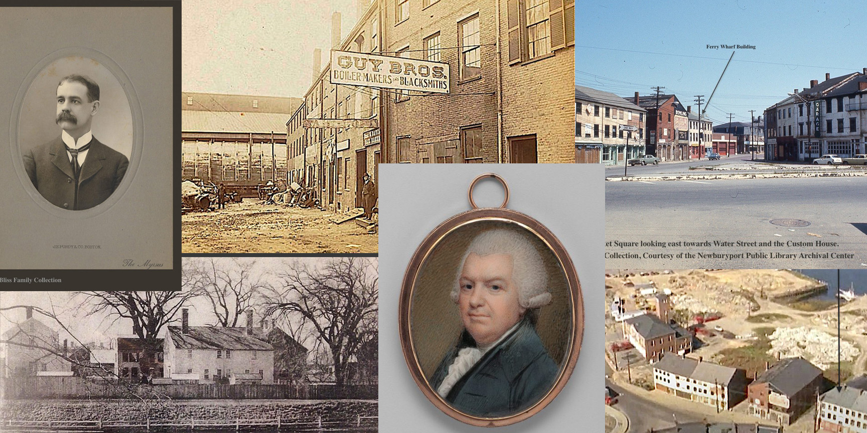
The wealthy and important men that no-one thought would ever be forgotten. Stephen Hooper one of the wealthiest men in Newburyport, a merchant and shipbuilder who married into one of Newburyport’ most important families and lived on a house on the Mall. No-one remembers him or the house that he lived in. Charles Bliss, one of the most beloved citizens in Newburyport, who died in in 1920, in 2021 no-one knew that he even existed. I managed to find and connect with his descendants and get some family photos and hopefully he and Stephen Hooper will now be remembered.

Newburyport History Map

The Women

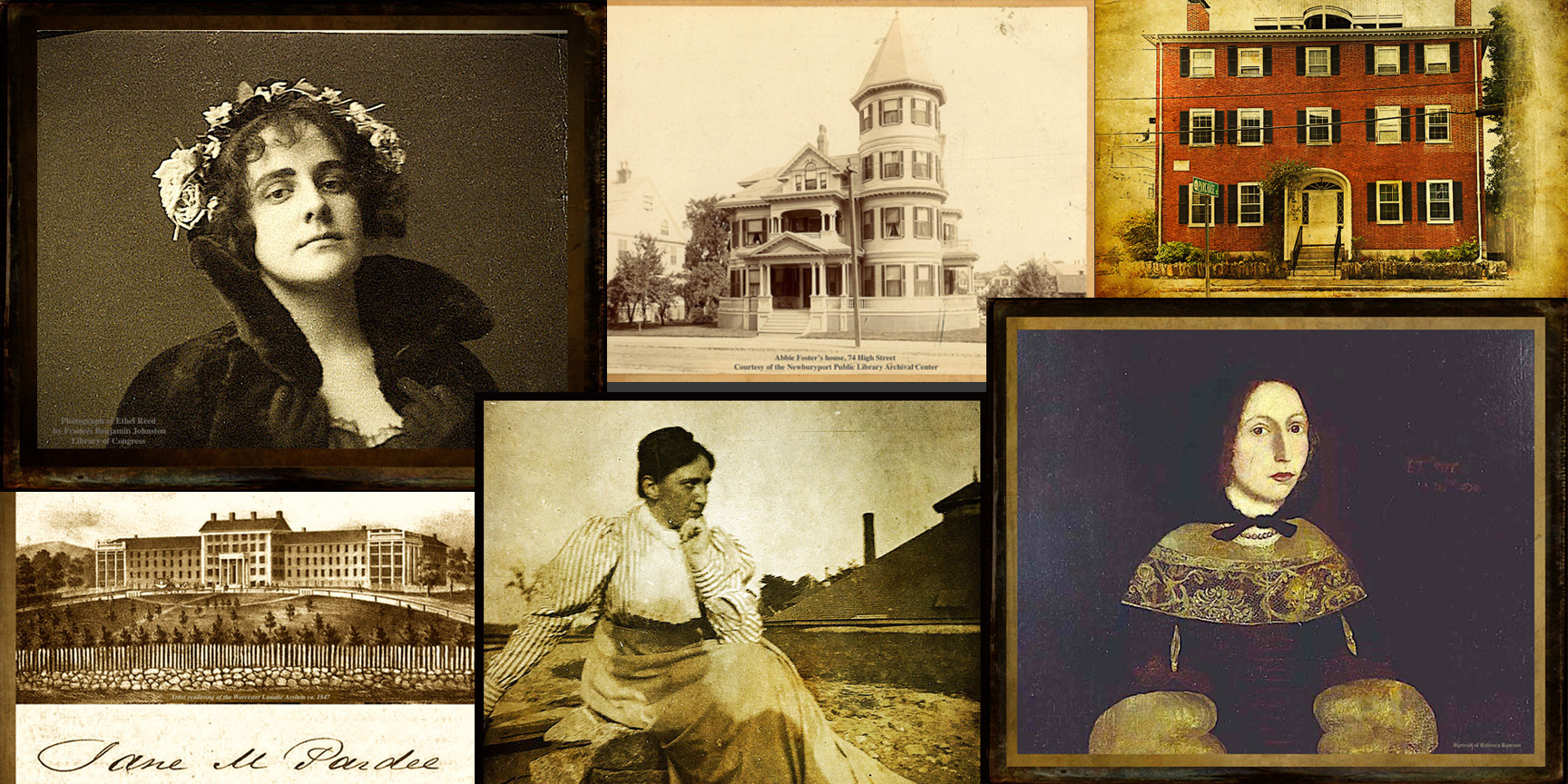
All the stories of the women. Rebecca Rawson who was deceived by a cad and abandoned. Ethel Reed who earned brief international fame as a poster artist in 1895, who was gilted by a rich Bostonian, and who died at the age of 36 somewhere in London.

Abbie Foster, the daughter of a shoemaker, who married Daniel Foster later in life. After her husband died, after two years of marriage, she built a gorgeous fancy mansion at 74 High Street. She probably was not welcomed by the people who challenged her husband’s will and maybe not the Newburyport’s upperclass. She lived in the fancy mansion with her servant until her death in 1913. Foster Court is named after her, and the only indication of her fascinating life.

Ethel Parton who was a famous writer of children’s books about 19th-century life in Newburyport, which were published in the 1930s and 1940s. At 69, she turned to her family’s stories and Newburyport’s history and began writing books for young adults. Until recently her name and story and books have been completely forgotten.

Jane Pardee, sent to lunatic asylum, maybe for her money, to come back, marry her niece’s husband, who may have been one of the men to put her in the asylum; to die in child birth in1862, two years after her marriage. Her husband and all of his children from his first marriage got her entire estate.

Margaret Atwood whose story is one of resilience, strength, generosity to those less fortunate than her – orphan girls and Native Americans. She was an astute businesswoman who ran her husband’s business after his death, rebuilt the Atwood Wharf after the fire of 1811, and not only survived but flourished after many others suffered economic hardship. Atwood Street is named after her.

The interactive map and the website History~Newburyport that coordinates with it, now has more stories on its blog, is not about the rare and important folks, it is about the stories and people that are mostly forgotten, that I hope people will read and now remember. A lot of the stories and research have come about from looking at deeds and wills and old newspapers, where stories are often buried and hidden, like the shipyard at the end of Jefferson Street at existed at least as early as the 1700s. My plan is to keep on exploring and putting more stories on the Newburyport Interactive History Map and to see what I learn next.

Explore the Newburyport Interactive History Map – Keeping the Story Alive.

A list of all the entries (with links) on the Newburyport Interactive History Map can be found here.

Working with GridPlay Designs to Create the New Website History~Newburyport

The home page of History ~ Newburyport

The home page of History ~ Newburyport. Both the beige and the dark teal color are from the 1851 map.

At the beginning of the pandemic I decided to create a new website that co-ordinated with the interactive history map, Newburyport – Keeping the Story Alive. I hired GridPlay Designs, and they did a gorgeous job in creating History ~ Newburyport.

It was a collaborative effort right from the start, I wasn’t even sure what the domain name should be, it is HistoryNewburyport.com, and it was so reassuring to have someone to think through that very basic and critical component.

slide show - GridPlay Designs

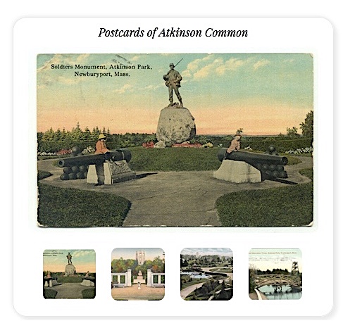
An example of the slide show that GridPlay Designs incorporated, postcards from Atkinson Common.

I gave them a section of the Newburyport 1851 map and a piece of the 1771 survey for Frog Pond, and told them I wanted it to be both historic and modern, I had no clue what it should look like. And they came up with this beautiful logo and design. They pulled the colors from the 1851 map and figured out how to use some of the calligraphy from the 1771 survey. I thought it was so elegant that I wasn’t sure I was worthy of the design.

GridPlay Designs incorporated the sage color

I love the way GridPlay Designs incorporated the sage color in the 1851 map in the design of every page.

They are very patient with me, I don’t process things in a linear fashion, but process things the way I would create a painting (I am a professional artist). It has been an ongoing collaborative achievement that has been both exciting and fun. We work together on every page, I provide the content and they create the page. I am always amazed at what they come up with. And if I think something needs to be tweaked, they are so patient and responsive, and things get thought through and updated immediately. It is rare, almost unheard, of to get such customer service.

Slide show - GridPlay Designs

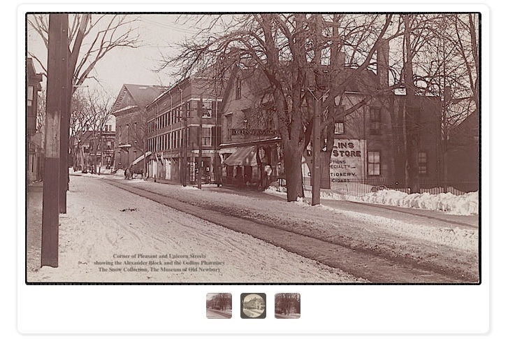
An example of the slide show that GridPlay Designs incorporated, old photographs of Unicorn Street.

We are still working on History ~ Newburyport and together we help it evolve. And the fact that together we were able to create a website, with 24 stories, full of content and historic photographs in two months, is remarkable. The website has been described as “beautiful,” “exciting,” “artistic,” and it would not have been any of those things without GridPlay Designs.

The home page of GridPlay Designs

The home page of GridPlay Designs

“We are passionate about working with entrepreneurs and small businesses that embody our values of honesty, integrity, kindness, creativity, and hard work.” ~ GridPlay Designs

History ~ Newburyport, a new website about Newburyport’s stories

History ~ Newburyport, a new Website about Newburyport's stories

History ~ Newburyport, a new Website about Newburyport’s stories

Ever since I started the interactive history map I’ve been thinking of doing this – creating a website that coordinates with the map. The pandemic has provided an opportunity to do that.

As I’ve been creating the interactive map, one story appears over and over again – Newburyport has been hugely successful and then faced crisis, often devastation and has always shown incredible resiliency, fortitude and the result has always been renewal. And as we are in the midst of this global pandemic, I thought it might be good story to emphasize.

I hired a professional web designer and graphic designer to do the website, GridPlay Designs. I think they did a gorgeous job. We are launching the site, HistoryNewburyport.com, Newburyport – Keeping the Story Alive with nine stories, but that’s just the start, there are so many stories to tell, and if you look at the interactive map, you will see, there are lots and lots and lots of stories.

Each page has a story, some are brief, some are longer. There are wonderful old photographs and maps, just like the interactive story map, and often a page also has a jigsaw puzzle about the story.

The website would not be possible without the incredibly generous help and use of the collection of both of the Museum of Old Newbury and the Newburyport Public Library Archival Center.

Ocean Mills – the Industrialization and the Expansion of the North End in the 1800s is on the Newburyport History Map

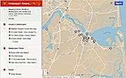
Newburyport Map - Keeping the Story AliveHere is the link to the map: Newburyport – Keeping the Story Alive, Mapping historic stories of Newburyport, MA houses and places, with photos, paintings, videos, old maps, history and anecdotes. Created by The Newburyport Blog, Mary Baker Eaton, editor. (This is one of the many stories that is on the map.)

map.HistoryNewburyport.com

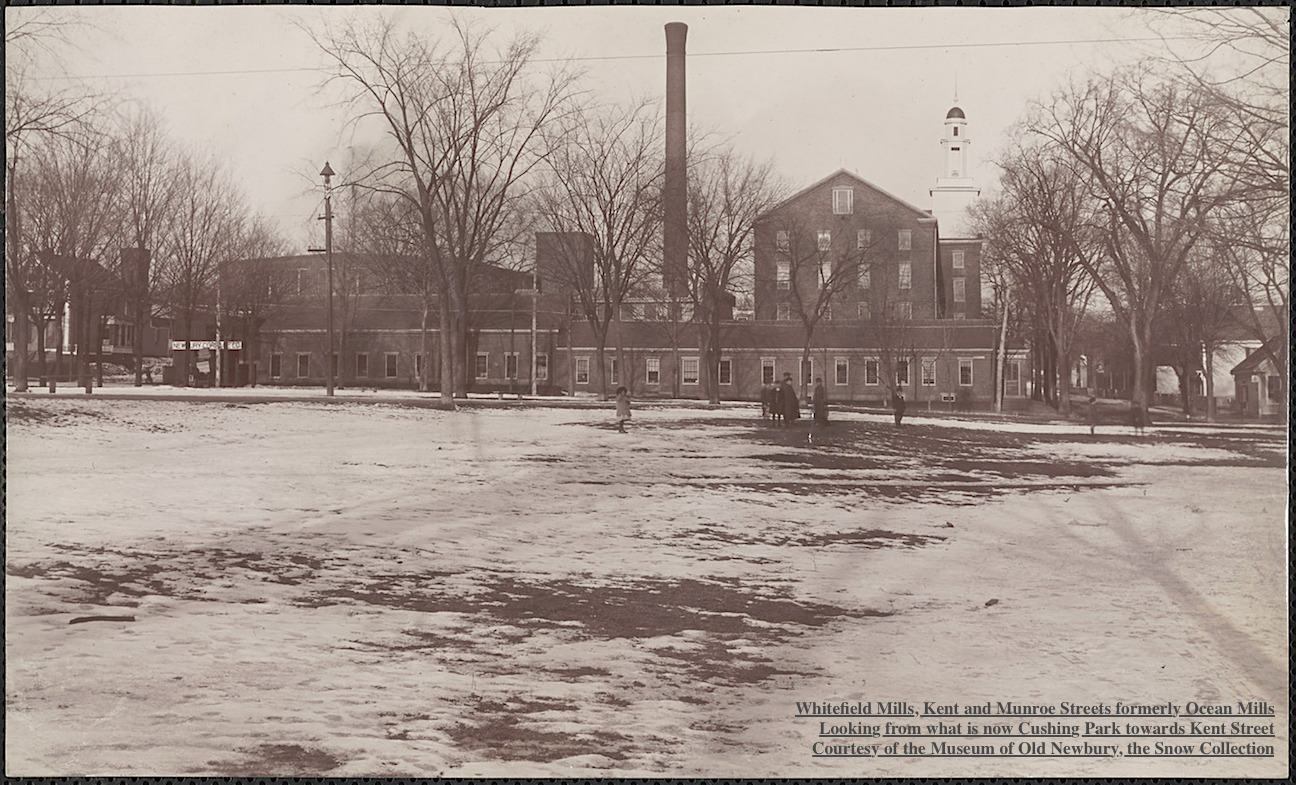
Whitefield Mills, Kent and Munroe Streets formerly Ocean Mills Courtesy of The Museum of Old Newbury, The Snow Collection

Whitefield Mills, Kent and Munroe Streets formerly Ocean Mills
Courtesy of The Museum of Old Newbury, The Snow Collection

Before 1845 the area between Munroe and High Streets was used for pasture and farming.

The Ocean Steam Mills were incorporated by the Massachusetts legislature in March 1845 by Benjamin Saunders, William Balch and Edward S. Lesley. The purpose was to manufacture of cotton cloth.

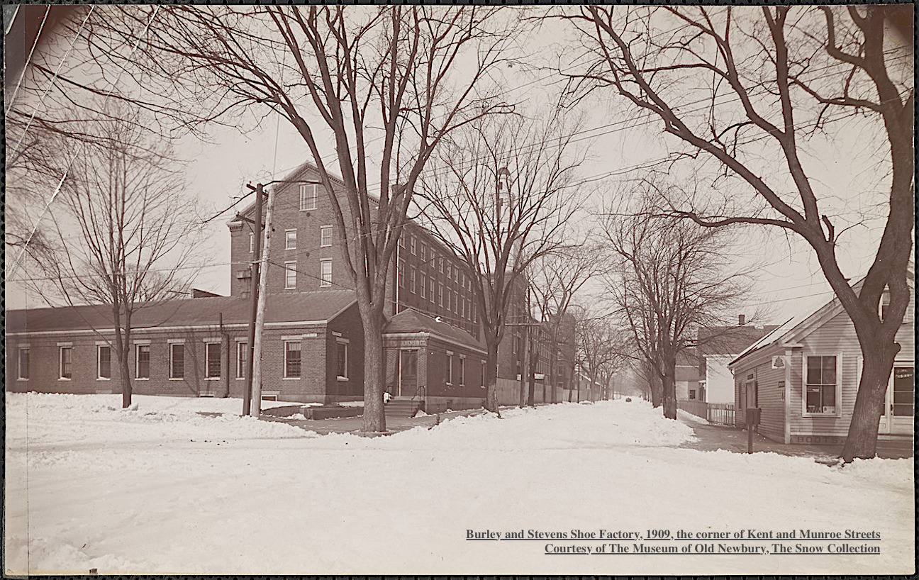
Burley and Stevens Shoe Factory, 1909 Courtesy of The Museum of Old Newbury, The Snow Collection

Burley and Stevens Shoe Factory, 1909
Courtesy of The Museum of Old Newbury, The Snow Collection

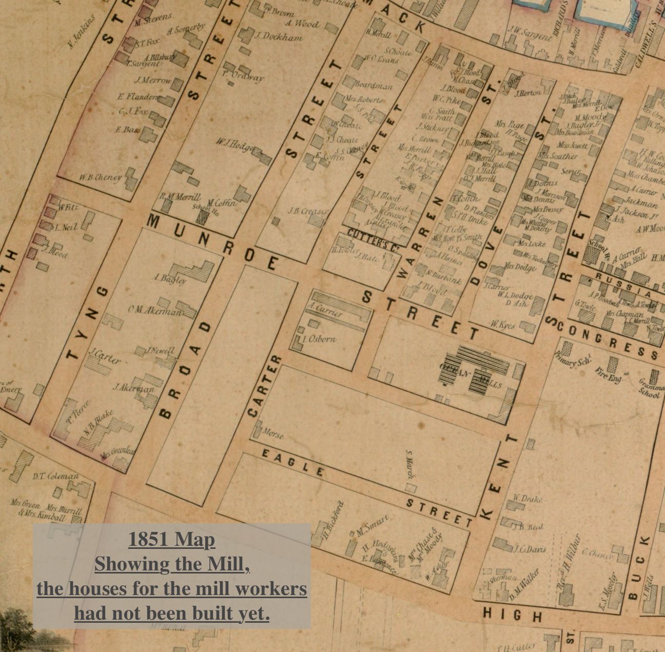
The company purchased a parcel of land on the corner of Kent and Munroe Streets extending to Carter Street. In 1845 the company started construction of a four story brick mill building between Kent and Warren Street. The mill was built by Albert Currier, a local contractor. The building was completed the next year and the manufacture of cotton sheeting and calico cloth began.

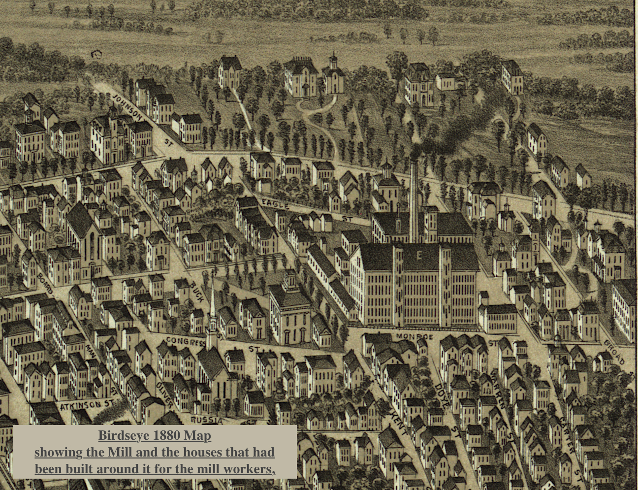
Birdseye view 1880 map showing the Mill and the houses that had been built around it.

Birdseye view 1880 map showing the Mill and the houses that had been built around it.

Around1 871 the property was sold and a new company, the Ocean Mills, continued the operation until 1878. At that time the property again changed hands and a third company, the Ocean Mills Company was formed.

1851 Map showing the Mill and that the houses around it had not yet been built.

1851 Map showing the Mill and that the houses around it had not yet been built.

In 1886 Seth Milliken of New York purchased the mills and name was changed to the Whitefield Mills. The mill did not succeed and in 1889 the machinery was sold to a Southern manufacturer.

Burley, Stevens & Co. manufactured boots and shoes leased the building as did the Bay State Cordage Company which made tarred cordage and binding twine. The Bay State Cordage Company closed in 1907, however Burley, Stevens & Co. continued. They finally closed and most of the mill was abandoned.

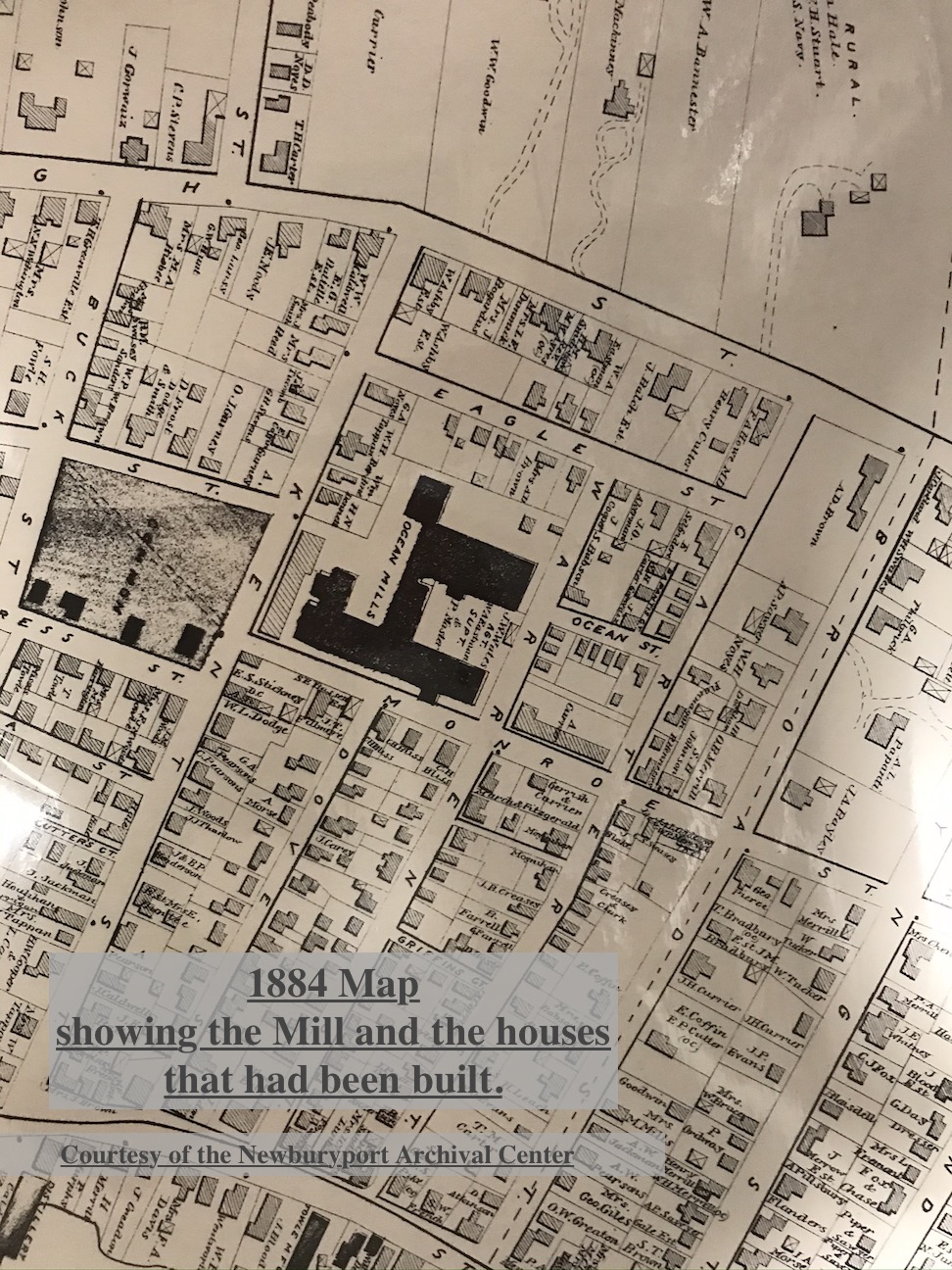
1884 Map, Courtesy of the Newburyport Archival Center, showing the Mill and the houses that had been built around it.

1884 Map, Courtesy of the Newburyport Archival Center, showing the Mill and the houses that had been built around it.

The millworkers needed homes close to their work and so there was a lot of new building on on Carter, Kent, Warren and Munroe Streets and the creation of what is now called the Ocean Mills Historic District, which is an excellent representation of a 19th Century Newburyport industrial neighborhood.

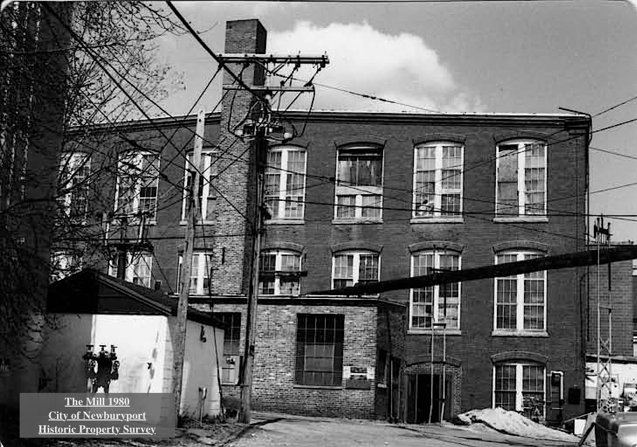
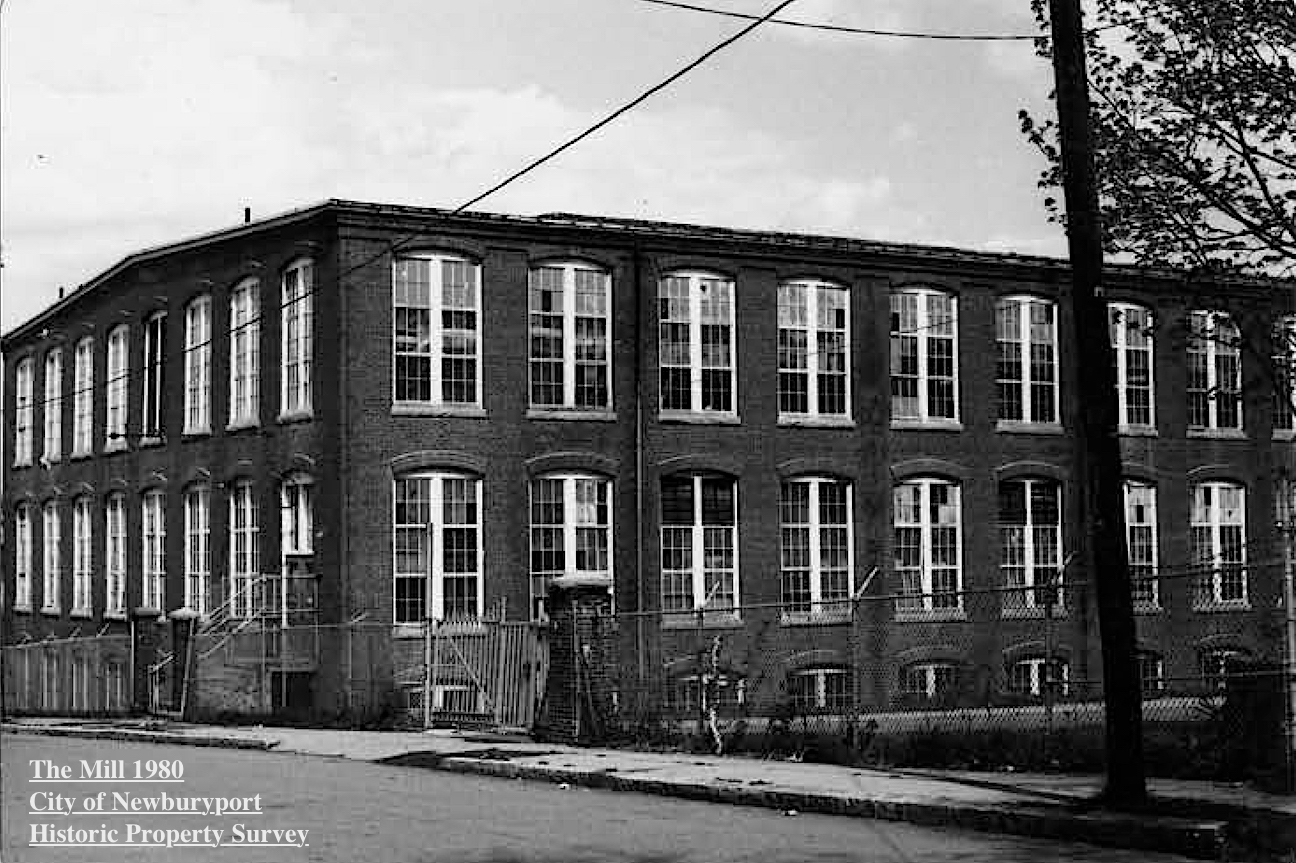
The Mill 1980, Courtesy of the City of Newburyport, Historic Property Survey

The Mill 1980, Courtesy of the City of Newburyport, Historic Property Survey

There were single family cottages, usually Greek Revival or Victorian in style, many are on Carter Street. The second type of residence was a larger home that was used as a boarding house. Three building were build on Munroe Street across from the Ocean Mill by James Blood, a real estate speculator. These house were generally Greek Revival in style. And then there were Victorian buildings and cottages with turned brackets decorating the doorways and sometime the eaves of the house. Albert Currier built one of these buildings on Munroe Street.

The Mill 1980, Courtesy of the City of Newburyport, Historic Property Survey

The Mill 1980, Courtesy of the City of Newburyport, Historic Property Survey

The overseers and the agents of the mill and skilled craftsmen associated with the industry also built home within this district. These homes were slightly more elaborate, as can be seen on upper Kent Street, they were often vernacular interpretations of one of the many popular Victorian styles such as Second Empire or Victorian Gothic.

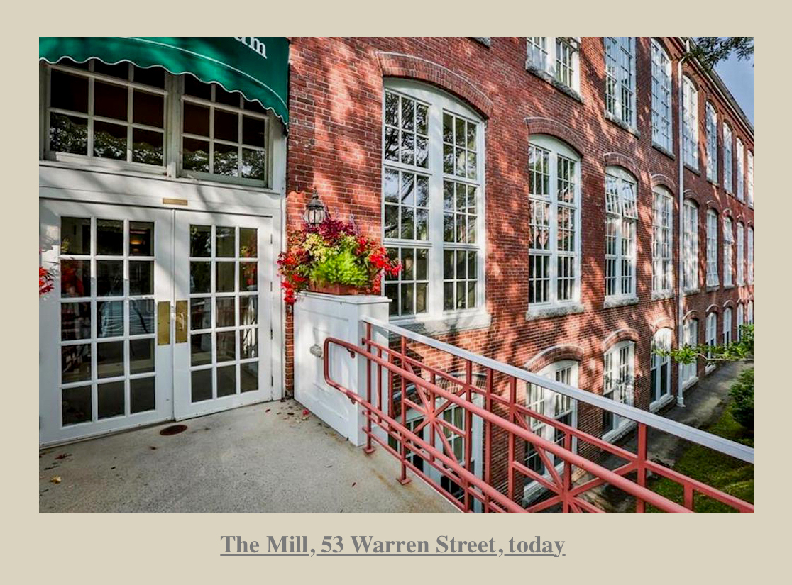
The Mill, 53 Warren Street today

The Mill, 53 Warren Street today

In 1941 the Hytron Radio and Electronics Corporation acquired the property for the manufacture of proximity fuse components and radio receiving tubes for the military, and later, television receiving tubes and cathode-ray tubes. In 1959 the factory closed with the loss of 3,000 jobs. In 1996 the building was turned in to luxury condominiums called “The Courtyard.”

History from The City of Newburyport, Historic Property Surveys “The Ocean Mills Historic District” and “53 Warren Street, Ocean Steam Mills,” John J. Currier, the History of Newburyport, and Jerry Mullins, author of the blog, Brick and Tree.

Whitefield Mills, Kent and Munroe Streets formerly Ocean Mills
Courtesy of the Museum of Old Newbury, the Snow Collection

Burley and Stevens Shoe Factory, 1909
Courtesy of the Museum of Old Newbury, the Snow Collection

The Mill 1980, Courtesy of the City of Newburyport, Historic Property Survey

This story is also now on the new website that coordinates with the interactive history map, HistoryNewburyport.com. .

History ~ Newburyport, a new Website about Newburyport's stories

History ~ Newburyport, a new Website about Newburyport’s stories


The story on Ocean Mills can be found here at the new website History ~ Newburyport HistoryNewburyport.com.

Story on Ocean Mills on the new website, History ~ Newburyport

Story on Ocean Mills on the new website, History ~ Newburyport


Moulton Castle is on the Newburyport Interactive History-Story Map

Newburyport Map - Keeping the Story AliveHere is the link to the map: Newburyport – Keeping the Story Alive, Mapping historic stories of Newburyport, MA houses and places, with photos, paintings, videos, old maps, history and anecdotes. Created by The Newburyport Blog, Mary Baker Eaton, editor. (This is one of the many stories that is on the map.)

map.historynewburyport.com

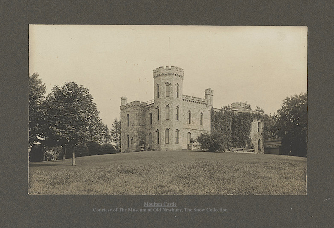
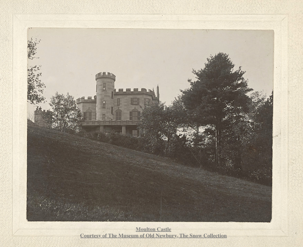
Moulton Castle Courtesy of The Museum of Old Newbury, The Snow Collection

Moulton Castle
Courtesy of The Museum of Old Newbury, The Snow Collection

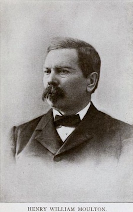
Henry William Moulton (1833 -1896)

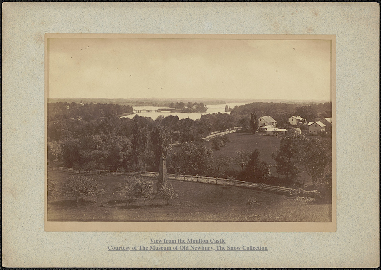
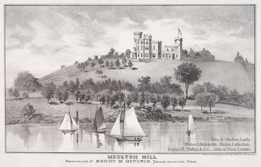
Captain Henry William Moulton returned to Newburyport after the the Civil War in 1865. He came into possession of Moulton Hill, overlooking the Merrimac River, which had been in different branches of Moulton family for six generations. The top of Moulton Hill was said to have the most beautiful landscape in all of New England. In 1868 he built a Gothic-style, 22-room wooden mansion, described as a “noble and picturesque home” on top of the hill, which became known as Moulton Castle.

View from Moulton Castle Moulton Castle Courtesy of The Museum of Old Newbury, The Snow Collection

View from Moulton Castle
Moulton Castle
Courtesy of The Museum of Old Newbury, The Snow Collection

Captain Moulton had six children, his only son died when he was less than a year and there was no son to assume his name and the estate.

View of Moulton Castle Boston Athenaeum, Digital Collection: George H. Walker & Co.'s Atlas of Essex County, Massachusetts. Boston, 1884, p. 143.

View of Moulton Castle
Boston Athenaeum, Digital Collection:
George H. Walker & Co.’s Atlas of Essex County, Massachusetts. Boston, 1884, p. 143.

Following Captain Moulton’s death in 1896, the property was bought by financier Charles W. Moseley who tore down Moulton Castle in December 1900. The site of the mansion is now known as Castle Hill and is part of Maudslay State Park.

Moulton Castle Courtesy of The Museum of Old Newbury, The Snow Collection

Moulton Castle
Courtesy of The Museum of Old Newbury, The Snow Collection

Part of the Poem called “Moulton Castle,” by Charles Clinton Jones

“It stood on a pine fringed hill-top
O’er looking the ancient town,
And the winding course of the river;
That turreted castle brown.
For more than a generation
It guarded the country-side,
The city and bay and islands,
And the marshes low and wide.”

Henry William Moulton (1833 -1896)

Henry William Moulton (1833 -1896)

History from The Moulton Family Search and the Boston Athenaeum and History of Maudslay State Park in Newburyport by Rebecca Beatrice Brooks

Photographs:
Courtesy of The Museum of Old Newbury, The Snow Collection
Boston Athenaeum, Digital Collection:
George H. Walker & Co.’s Atlas of Essex County, Massachusetts. Boston, 1884, p. 143.

This story is also now on the new website that coordinates with the interactive history map, History ~ Newburyport at  HistoryNewburyport.com.

History ~ Newburyport, a new Website about Newburyport's stories

History ~ Newburyport, a new Website about Newburyport’s stories

The story on Moulton Castle can be found here at the new website History ~ Newburyport HistoryNewburyport.com.

Story on Moulton Castle on the new website, History ~ Newburyport

Story on Moulton Castle on the new website, History ~ Newburyport

Eliphalet Griffin is on the Map, The Home for Aged Men, 5 Columbus Ave, 31-35 Pleasant Street

Newburyport Map - Keeping the Story AliveHere is the link to the map: Newburyport – Keeping the Story Alive, Mapping historic stories of Newburyport, MA houses and places, with photos, paintings, videos, old maps, history and anecdotes. Created by The Newburyport Blog, Mary Baker Eaton, editor. (This is one of the many stories that is on the map.)

map.historynewburyport.com

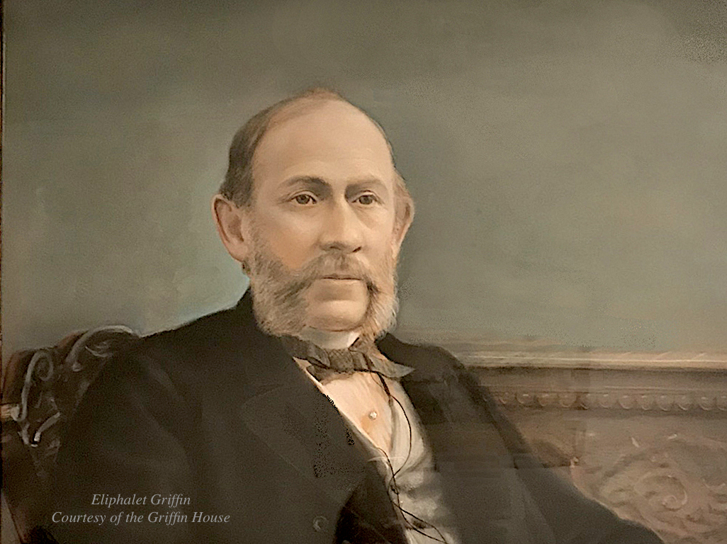
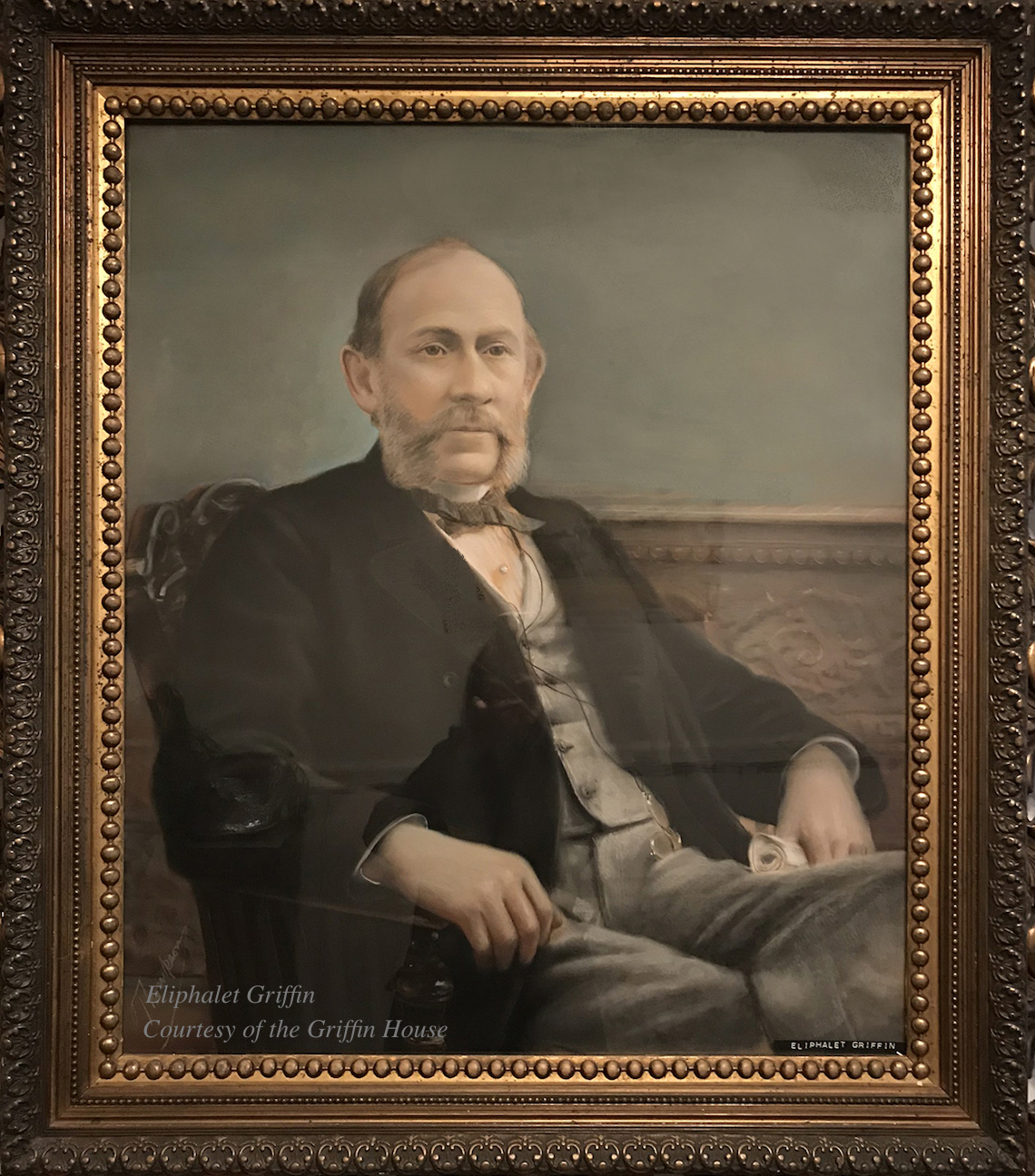
Portrait (detail) of Epliphet Griffin courtesy of The Griffin House

Portrait (detail) of Epliphet Griffin courtesy of The Griffin House

Eliphalet Griffin (1824 – 1899) was born in Newburyport in 1824. He started out as a clerk for a dry goods store and then opened his own store downtown. The Newburyport Daily News reported that in the early 1850s he went to California, which would have been during the California Gold Rush and opened a successful and prosperous wholesale clothing house. When he returned to Massachusetts he worked for a firm in Boston that had a large contract during the Civil War that sold uniforms for the United States government. Eliphalet Griffin returned to Newburyport in the 1860s a wealthy man.*

Portrait (detail) of Epliphet Griffin courtesy of The Griffin House

Portrait (detail) of Epliphet Griffin courtesy of The Griffin House

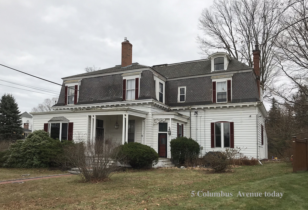
In 1863 he married Elizabeth Balch of Newburyport and they had two children. The City Directories show Eliphalet living at 31 Tyng Street, however in 1869 he built a Second Empire style house on what was then the corner of High Street and Columbus Avenue, and upon completion it was reported in the Newburyport Herald that it was “one of the best Newburyport houses in modern times.”** The 1870 Census shows that Eliphalet is 44, Elizabeth is 40, their daughter Hannah is 5 and their son Eliphalet is 3.

Epliphet Griffin's house, 5 Columbus Ave, today

Epliphet Griffin’s house, 5 Columbus Ave, today

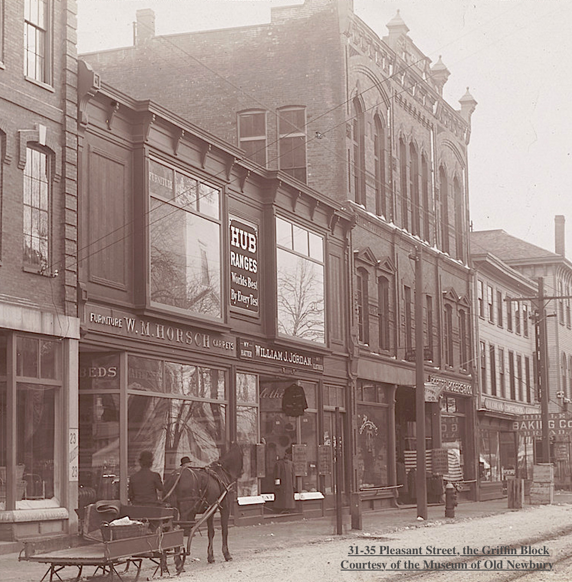
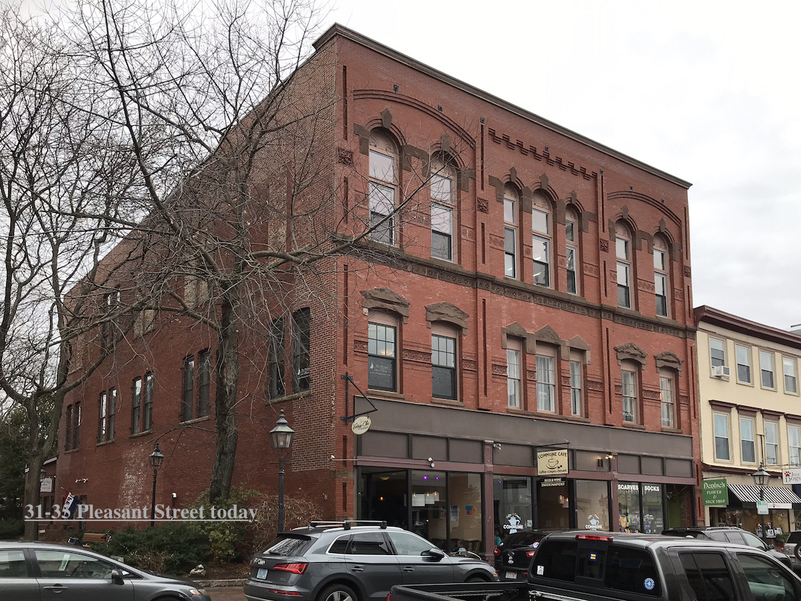
Epliphet built a beautiful three story, Queen Anne/Panel Brick style building on Pleasant Street, now 31-35 Pleasant Street, completed in 1889 which still stands today. The first floor contained two storefronts, a series of offices on the second floor and a large hall on the third floor. The hall was known as Griffin Hall and was the scene of many dances in the 1950s, it also showed moving pictures before a law was passed that movie theaters must be on the ground floor. In the 1890 the ground floor was occupied by the Boston Boot & Shoe Company and Kent & Bolton clothiers and finishers. Later it was leased to Woolworth’s and to Boxer’s Furniture among other establishments. ***

The photograph of the Griffin Block ca. 1890–1899 is courtesy of the Museum of Old Newbury.

The photograph of the Griffin Block ca. 1890–1899 is courtesy of the Museum of Old Newbury.

31-35 Pleasant Street today

31-35 Pleasant Street today

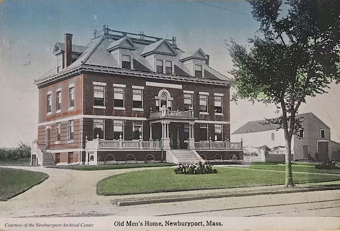
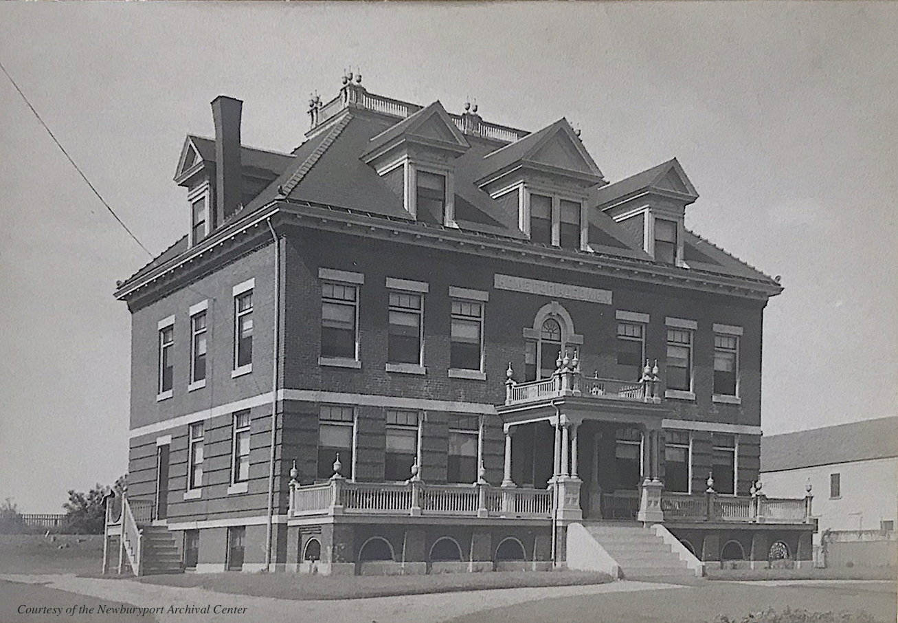
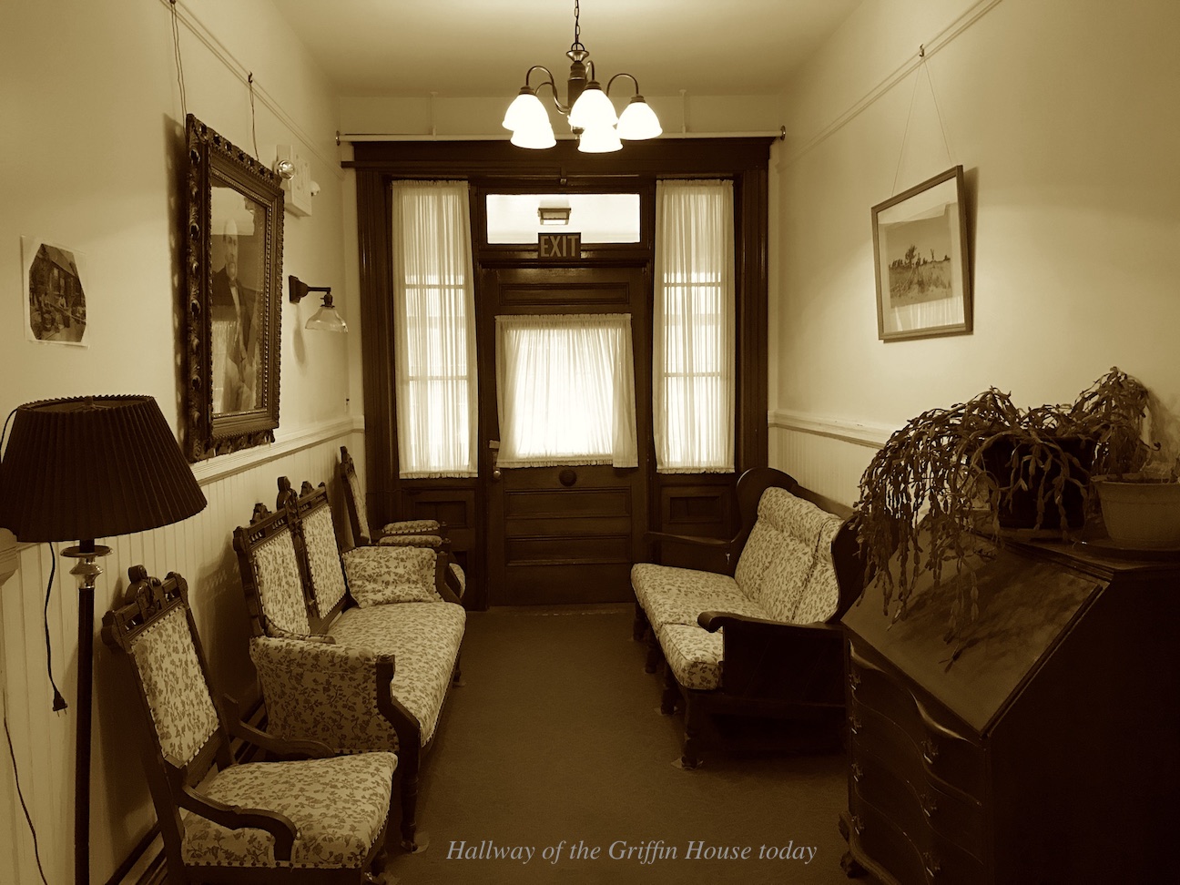
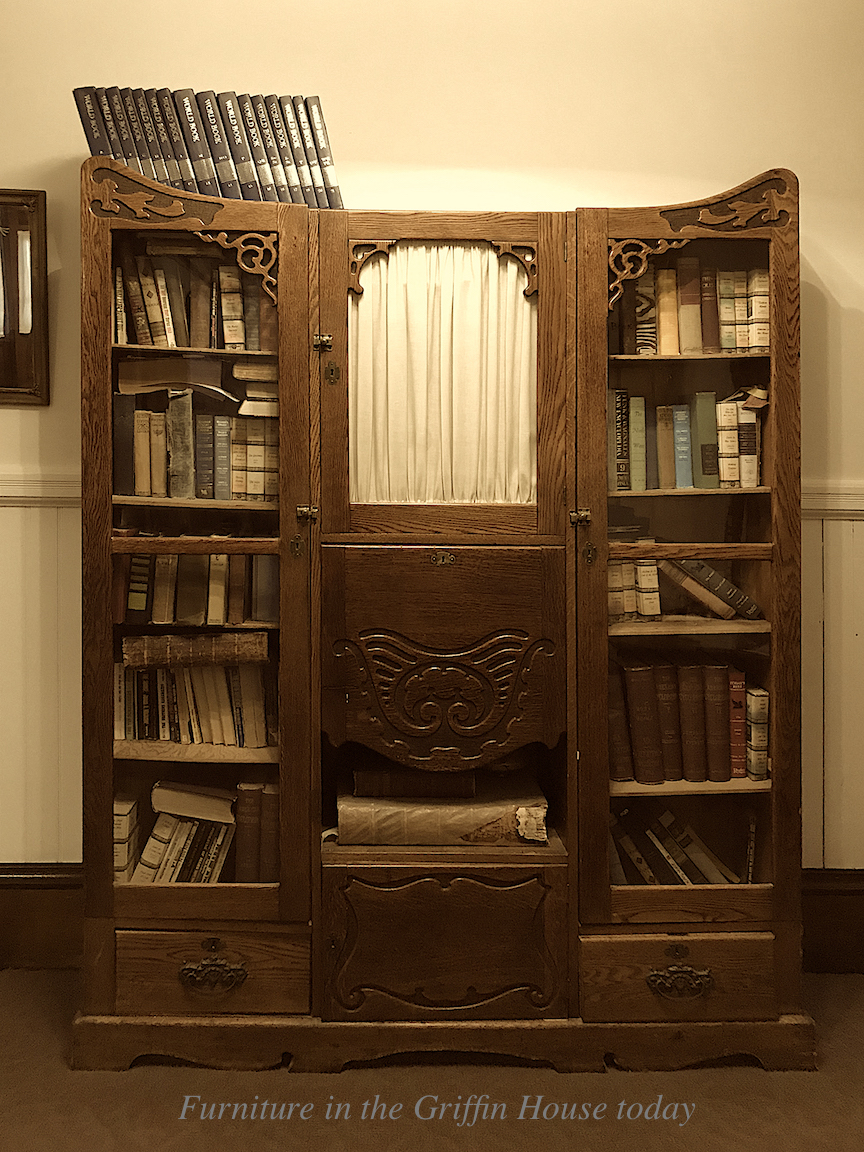
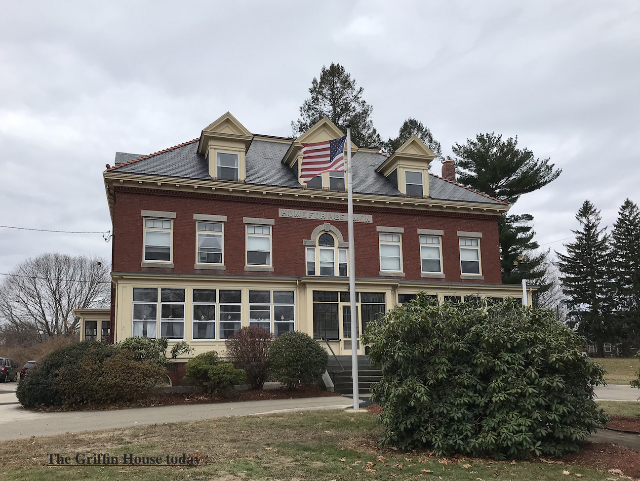
Epliphet’s great passion, however, was building the Griffin House, the Home for Aged Men at 363 High Street across from Atkinson Common. In 1886 along with Albert W. Greenleaf and Lawrence B. Cushing, Epliphet created the Newburyport Society for the Relief of Aged Men. Epliphet gave the society the lot of land and built the foundation of the brick building at his own expense in 1896. The building was completed two or three years later. Mr Griffin died in 1899. Due to lack of funds the home remained unfurnished and unoccupied until 1902. ^* Much of the original furniture and woodwork remains in the house today. The Griffin House contains 9 rooms, the men must be 65 and able to take care of themselves. Some of the staff have been there for over 3 decades, the home is a family and the inside feels and looks very much like it must have looked in 1906. It is a wonderful place.

The postcard of the Griffin House, courtesy of the Newburyport Archival Center

The postcard of the Griffin House, courtesy of the Newburyport Archival Center

The postcard of the Griffin House, courtesy of the Newburyport Archival Center

The postcard of the Griffin House, courtesy of the Newburyport Archival Center

The hallway of The Griffin House today

The hallway of The Griffin House today

Furniture in The Griffin House today

Furniture in The Griffin House today

The Griffin House today

The Griffin House today

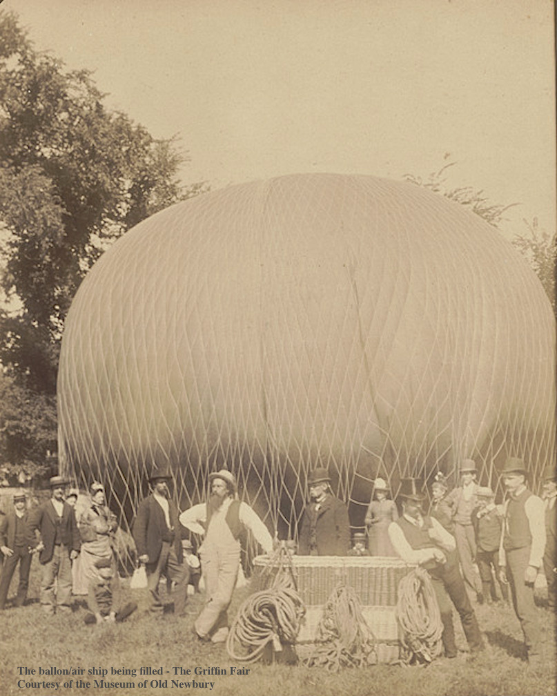
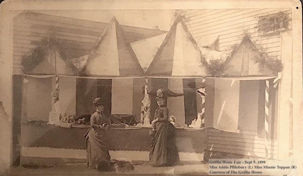
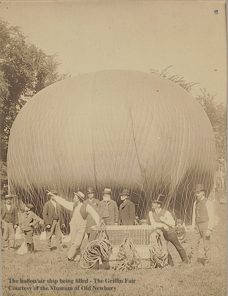
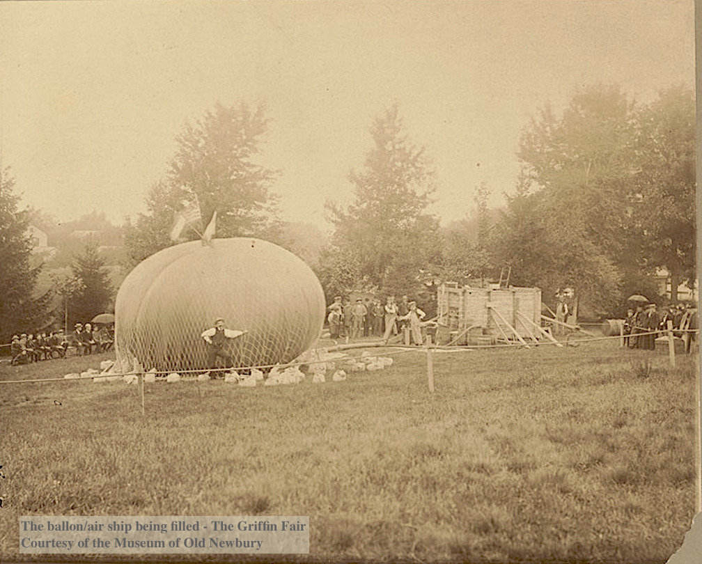
Epliphet Griffin organized the most amazing fairs at his home on High Street to raise funds for the Home for Aged Men. One fair is described in the Newburyport Herald, Sept 21, 1887 in which 5000 – 6000 people attended. The main attraction was a “great air ship” 126 feet in circumference and 42 feet in diameter. Ultimately the balloon did not ascend, it was not able to be filled with the 150,000 feet of gas that was required. The Museum of Old Newbury has three photographs of the balloon.

The photograph of the the ballon/air ship being filled is courtesy of the Museum of Old Newbury.

The photograph of the the ballon/air ship being filled is courtesy of the Museum of Old Newbury.

The photograph of the the ballon/air ship being filled for the Fair is courtesy of the Museum of Old Newbury.

The photograph of the the ballon/air ship being filled for the Fair is courtesy of the Museum of Old Newbury.

The photograph of the the ballon/air ship being filled for the Fair is courtesy of the Museum of Old Newbury.

The photograph of the the ballon/air ship being filled for the Fair is courtesy of the Museum of Old Newbury.

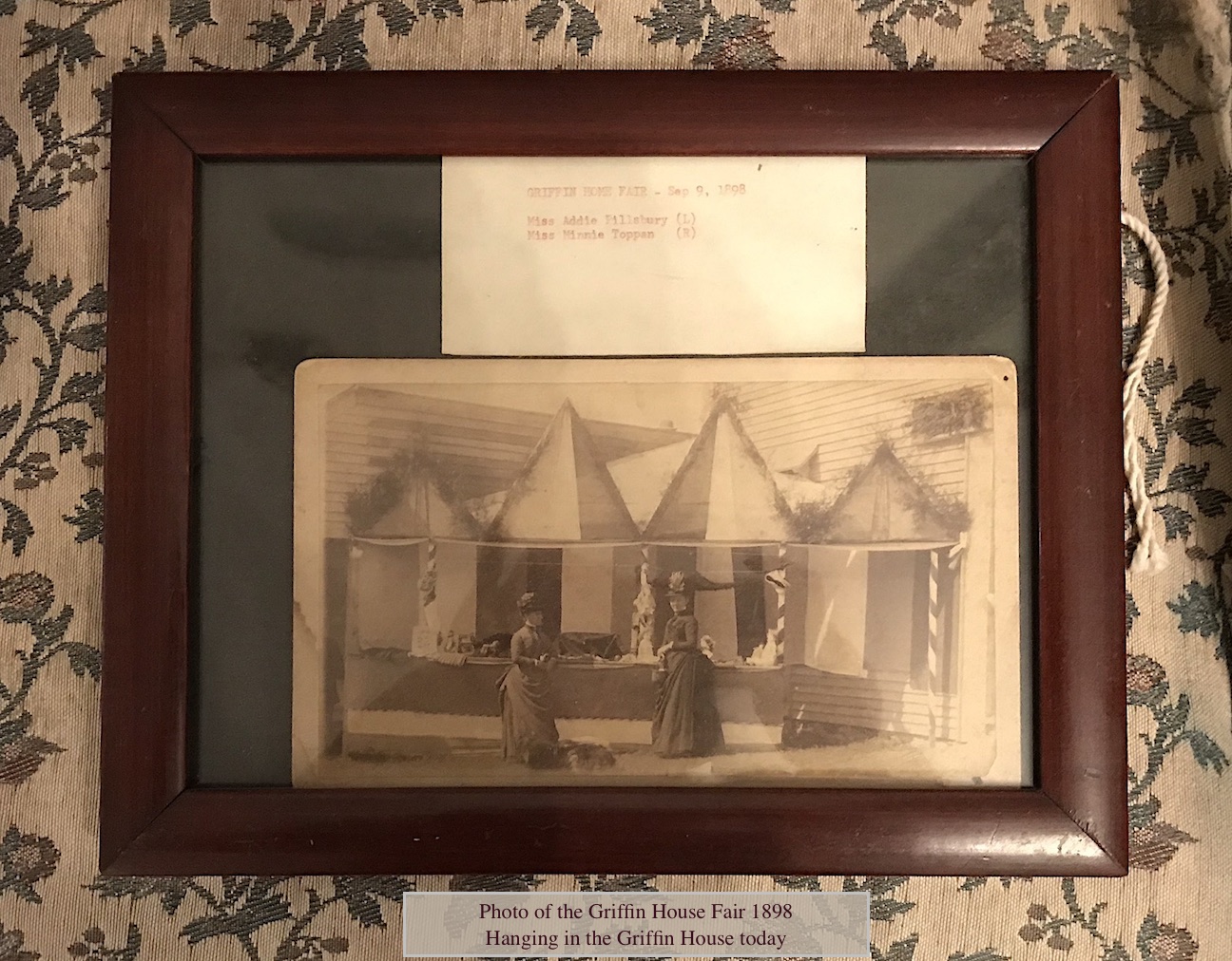
There were many attractions, however, beside the balloon – a concert, various booths and tents, dancing, ice cream, candy, soda and fruit; a supper that provided cold roast chicken, ham, corned beef, lamb, baked beans, rolls, bread, oysters, chicken and lobster salad, many kinds of cake, cream cakes and pies. The large barn was filled to overflowing for the dances, there were floral processions by 500 children, and a band played both in the afternoon and evening. ^** Eliphalet Griffin knew how to throw a great party and raised a great deal of money for the Home for Aged Men. How wonderful that the Griffin House still exists today, basically unchanged.

Griffin Home Fair - Sept 9, 1898, hanging in The Griffin House today Miss Addie Plllisbury (L) Miss Minnie Toppan (R) Courtesy of The Griffin House

Griffin Home Fair – Sept 9, 1898, hanging in The Griffin House today
Miss Addie Plllisbury (L) Miss Minnie Toppan (R)
Courtesy of The Griffin House

Griffin Home Fair - Sept 9, 1898, hanging in The Griffin House today Miss Addie Plllisbury (L) Miss Minnie Toppan (R) Courtesy of The Griffin House

Griffin Home Fair – Sept 9, 1898, hanging in The Griffin House today
Miss Addie Plllisbury (L) Miss Minnie Toppan (R)
Courtesy of The Griffin House

* Newburyport Daily News, July 11, 1899
** The Historical Society of Old Newburyport
*** City of Newburyport Historical Property Surveys
^* John J. Currier, History of Newburyport, Vol II
^** Newburyport Herald, Sept 21, 1887

Portrait of Epliphet Griffin courtesy of the Griffin House

The photographs of the the ballon/air ship being filled are courtesy of the Museum of Old Newbury.

The postcards of the Griffin House are courtesy of the Newburyport Archival Center

The photograph of the Griffin Block ca. 1890–1899 is courtesy of the Museum of Old Newbury.

Griffin Home Fair – Sept 9, 1898
Miss Addie Plllisbury (L) Miss Minnie Toppan (R)
Courtesy of The Griffin House 

The story on the Griffin House can be found here at the new website History ~ Newburyport HistoryNewburyport.com.

Story on the Griffin House on the new website, History ~ Newburyport

Story on the Griffin House on the new website, History ~ Newburyport

An Unlikely Friendship between two Bloggers from Georgia and Newburyport

Sam Burnham and I formed an unlikely friendship in these divisive times. Sam is from Georgia, he is a Southern conservative and I am from Newburyport, Massachusetts, a Northern moderate liberal. We got to know each other when a pretty vicious website attacked where we lived in October 2015 for “click bate.”  Sam and I were both pretty angry (so were a lot of other folks) and spoke up online against the two click bate young men who were behind it. Sam and I stayed in touch. He writes a blog, very much like mine, loves historic preservation, loves where he lives, his blog is called All the Biscuits in Georgia. Sam is a gentleman. 

And since our country is so at odds with each other, Sam and I have mulled over the idea of how to transcend the cultural divide. 

Sam started by including Newburyport in a blog post, he used two gorgeous photos and talked about the heroic achievement of Urban Renewal. It was very nice of him. 

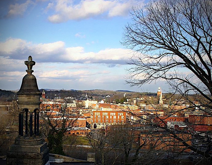
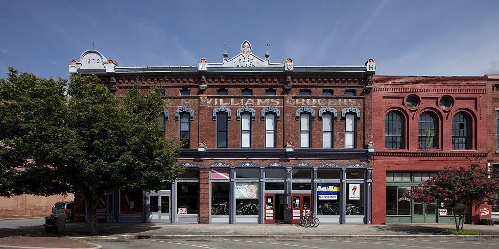
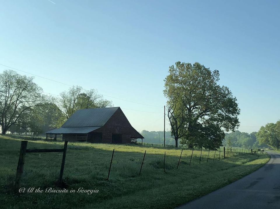
Here are two photos of Rome, Georgia, and one of rural Georgia, both are very important to Sam. 

Rome, Georgia

Rome, Georgia

Rome, Georgia, historic Broad Street

Rome, Georgia, historic Broad Street

Near Adairsville, Ga, Courtesy and © All the Biscuits in Georgia

Near Adairsville, Ga, Courtesy and © All the Biscuits in Georgia

Sam and I disagree about a lot of stuff, but we also agree about a lot of stuff. We shared a common “adversary,” we also share a passion for historic preservation and a passion about the “sense of place” where we live.

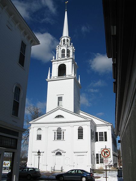
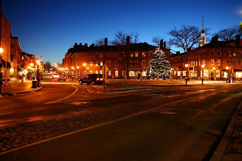
Here are the photos of Newburyport that Sam put up on his blog post.

Unitarian Church on Pleasant Street, Newburyport, MA

Unitarian Church on Pleasant Street, Newburyport, MA

Newburyport, Market Square

Newburyport, Market Square

The Building of Rt 1 in Newburyport and the Neighborhood that Disappeared

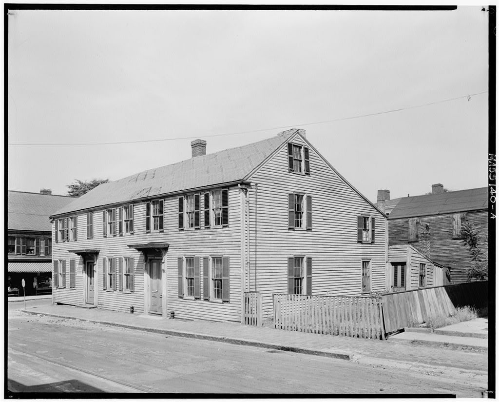
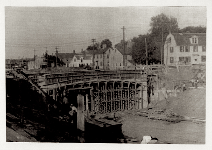
I’ve been working on an art series using historic photographs in the Public Domain from the South. It’s been really fun and an amazing combination of my love for historic preservation and art and painting. I thought that I would experiment with historic images from the Public Domain that are in Newburyport. The ones in Newburyport in the Pubic Domain are from the Library of Congress and are of a neighborhood between Summer and Winter Streets that disappeared with the building of Rt 1 in 1934. 

32 Summer Street, Newburyport - Digital Image

32 Summer Street – Digital Image

32 Summer Street – Digital Image

Building dates c 1760 and was taken down for Rt 1

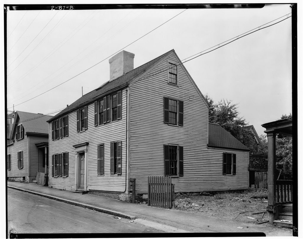
Marden House, 32 Summer Street, Newburyport, Essex County, MA
Historic American Buildings Survey
C 1934
Original image from the Library of Congress

https://www.loc.gov/resource/hhh.ma0664.photos/?sp=2

32 Summer Street, Newburyport, Courtesy of the Library of Congress

32 Summer Street, Newburyport, Courtesy of the Library of Congress

32 Summer Street, the original image from the Library of Congress

5 Birch Street, Newburyport - Digital Image

5 Birch Street – Digital Image

5 Birch Street – Digital Image

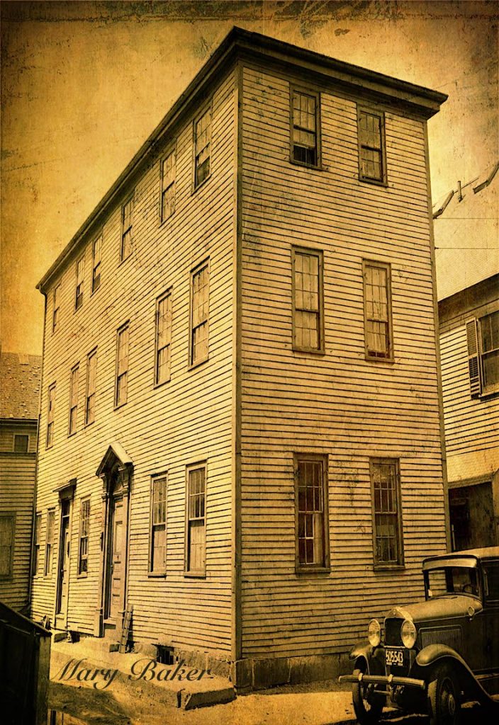
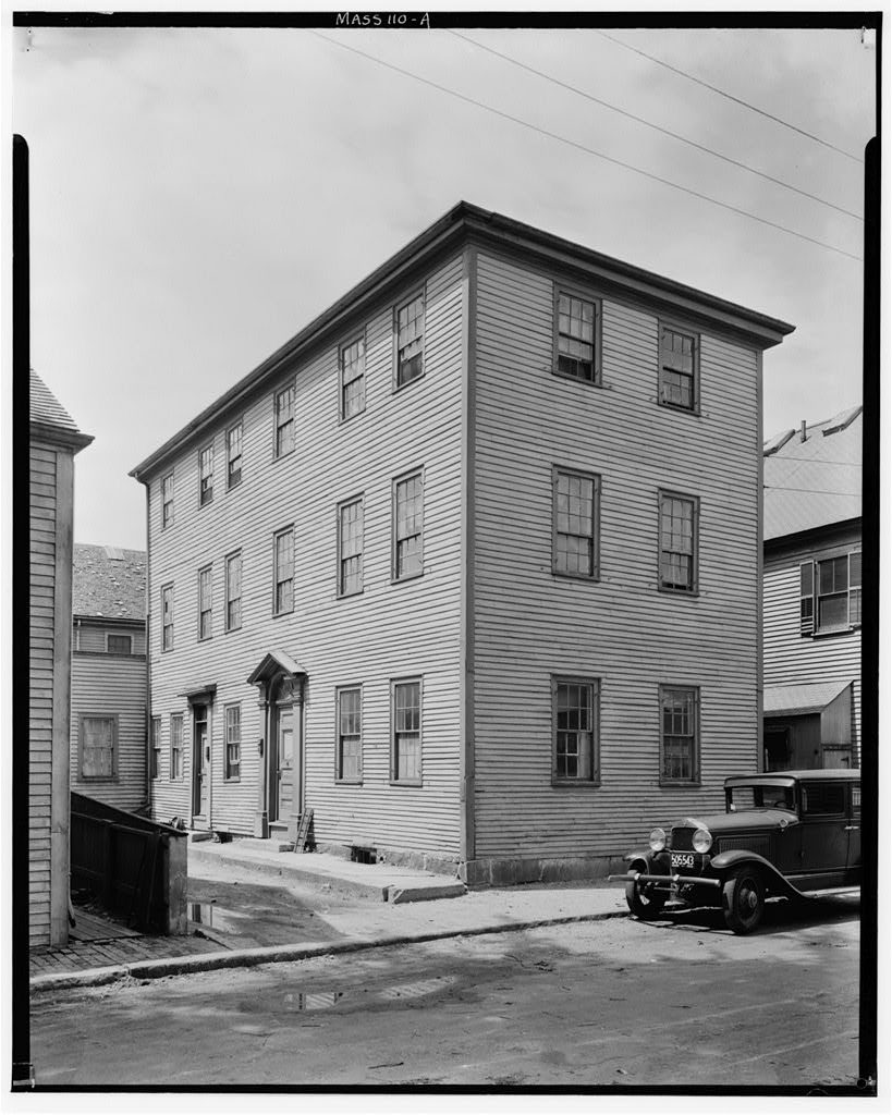
The building dates c 1740 and was taken down for Rt 1. 

Stockman House, 5 Birch Street, Newburyport, Essex County, MA 
Historic American Buildings Survey
c 1934
Original image from the Library of Congress

https://www.loc.gov/resource/hhh.ma0670.photos/?sp=1

5 Birch Street, Newburyport, Courtesy of the Library of Congress

5 Birch Street, Courtesy of the Library of Congress

5 Birch Street the original image from the Library of Congress

31-33 Winter Street, Newburyport- Digital Image

31-33 Winter Street – Digital Image

31-33 Winter Street – Digital Image

The building dates c 1770 and was taken down for Rt 1. 
Original image is from the Library of Congress
Charles Stockman House, 31-33 Winter Street, Newburyport, Essex County, MA
Historic American Buildings Survey
c. 1934
The original image from the Library of Congress

https://www.loc.gov/resource/hhh.ma0671.photos/?sp=1

31-33 Winter Street, Newburyport, Courtesy of the Library of Congress

31-33 Winter Street, Courtesy of the Library of Congress

31-33 Winter Street, the original image from the Library of Congress 

7 Birch Street, Newburyport - Digital Image

7 Birch Street, Newburyport – Digital Image

7 Birch Street – Digital Image

Building dates c 1815 and was taken down for Rt 1

Original image from the Library of Congress

Regan House, 7 Birch Street, Newburyport, Essex County, MA
Historic American Buildings Survey, creator
c. 1934
The original image from the Library of Congress

https://www.loc.gov/resource/hhh.ma0667.photos/?sp=1

7 Birch Street, Newburyport, Courtesy of the Library of Congress

7 Birch Street, Newburyport, Courtesy of the Library of Congress

7 Birch Street, the original image from the Library of Congress 

Building Rt 1, c 1934, Courtesy of the Newburyport Archival Center

Building Rt 1, c 1934, Courtesy of the Newburyport Archival Center

This is the building of Rt 1 Courtesy of the Archival Center at the Newburyport Public Library

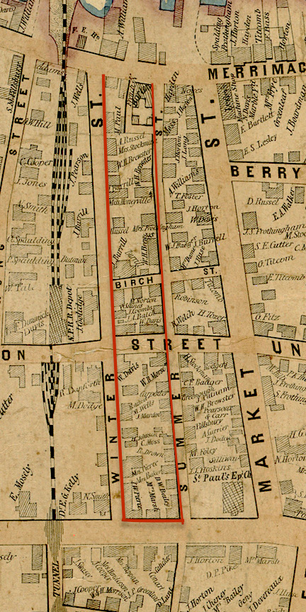
1851 Map, Winter and Summer Streets, Newburyport

1851 Map, Winter and Summer Streets, Newburyport

And this is what the neighborhood looked like from an 1851 map. Inside the red lines are the buildings that were taken down to make room for the roadway. 

Keeping the Tradition of Community in the South End Alive


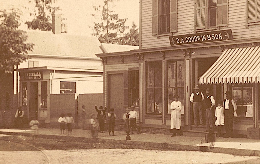
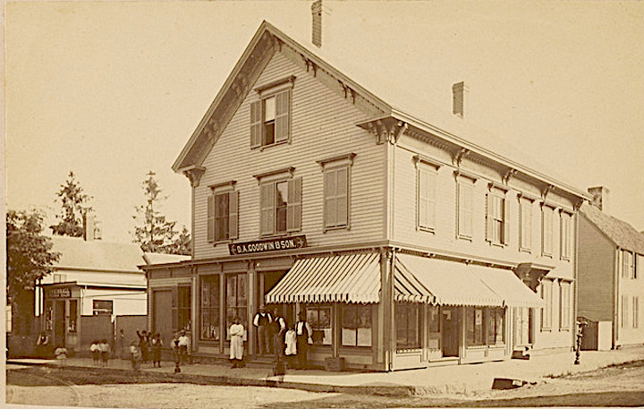
Corner of Purchase and Lime Streets, Newburyport, MA, D.A. Goodwin Groceries

Corner of Purchase and Lime Streets, Newburyport, MA, D.A. Goodwin Groceries, Courtesy of the Museum of Old Newbury

The Corner of Purchase and Lime Streets, Courtesy of the Historical Society of Old Newbury, The Snow Photograph Collection, D. A. Goodwin and Sons Grocery Store – 1864-1917  https://www.digitalcommonwealth.org/search/commonwealth:tq57pr04v

The Brown School was one of the last vestiges of the neighborhood feel of the South End. With the loss of the Brown School the neighborhood lost a place to meet, congregate and make connections that have lasted for some, a lifetime. It is one of the reasons that the neighborhood so appreciates the Newburyport Youth Services. Whatever happens to that site, it would be wonderful to include a place where people can congregate and make neighborhood connections. The Emma Andrews Library and Community Center  (which is located at the corner of Marlboro and Purchase Streets)  is in incredible example of how the neighborhood made a small place into a connected space for people of all ages, run by a dedicated and imaginative group of volunteers. 

The space could be called something like the “George Brown, South End Community Center.” It would not have to be a large space. The Emma Andrews has a handicapped bathroom, a handicapped entrance, a portable refrigerator and coffeemaker and some furniture. That is all the space would need. It could have a small lending library, photos of what the neighborhood once looked like that are available through the Archival Center at the Newburyport Library and the Museum of Old Newbury to keep memories of the neighborhood alive. It could be a place where art is shown, story hours for children, potluck lunch and dinners, book clubs – there are all kinds of ideas. We could also make a space for a few community gardens, something that people have wanted for a long time, where the playground and park will eventually be located, to keep that area vibrant and welcoming, as well as edible. 

As the City wrestles with what to do with this very complex and expensive site ($14 – $20 million estimated in 2014) it would be good to have as part of any eventual plan a place that keeps the fabric of the neighborhood alive and keep the South End tradition of a place where people gather, mingle, find friendship, support and commonality.

Corner of Purchase and Lime Streets, Newburyport, MA, D.A. Goodwin Groceries

Corner of Purchase and Lime Streets, Newburyport, MA, D.A. Goodwin Groceries, Courtesy of the Museum of Old Newbury

The Corner of Purchase and Lime Streets, Courtesy of the Historical Society of Old Newbury, The Snow Photograph Collection, D. A. Goodwin and Sons Grocery Store – 1864-1917 https://www.digitalcommonwealth.org/search/commonwealth:tq57pr04v


High Street is Wide Around Buck, Johnson and Kent Streets

A detail of a 1807 map that shows the wide part of High Street, Courtesy of the Newburyport Archival Center

A detail of a 1807 map that shows the wide part of High Street, Courtesy of the Newburyport Archival Center

A detail of a 1807 map that shows the wide part of High Street, Courtesy of the Newburyport Archival Center

After the fight to save High Street that began in 1998, the High Street Master Plan came into being and the first (and only phase) of the High Street Master Plan was implemented – the bike lanes. There was such a “hubbub” about the bike lanes (they’d  been talked about for 6 years) that they were never actually finished, the High Street Master Plan was vetoed in mid-execution. However, it was finally passed unanimously by the Newburyport City Council, but funding had long since dried up for any further pursuit of the High Street Master Plan.

One of the areas that had long been of concern was the very wide part of the road between Buck, Johnson and Kent Streets. Two years ago the city got a grant to narrow that part of the road and emphasizing biking, walking and being able to safely cross that area of the street, which is really dangerous.*^*  Geordie Vining of the Newburyport Planning Office asked Sharon Spieldenner of the Newburyport Archival Center if there was any reason why that particular part of High Street was so wide. It sounded like a really fun research project and I was “all in.”

This is what we’ve discovered so far.

“Tradition says that it (High Street) was an Indian trail in the beginning, as the low land along the river banks was marshy and sandy, hard to travel upon.” *

“ The country road, now High Street, was then a narrow path or way leading to the ferry at Carr’s island.  Under the direction of the way wardens, or surveyors of highways, it was laid out, four rods wide, for a distance of six miles from the north bank of the Parker river (“High Street, beginning at the Parker River and extending to Three Roads so called.” **^^) (Currier is referring in this paragraph to the year 1649).  Recently the road-bed had been greatly improved by reducing the grade in some places, and laying a firm and solid foundation of broken rock, covered with a finer coating of the same material, nearly the  whole length of the road. When the work is completed, this ancient thoroughfare will be under the care and control of the Board of Highway Commissioners appointed by the state.” **

Boardman Street was laid out as a “way” in 1754 and was called Boardman lane, and then was called Boardman Street in 1764 (when the city separated from Newbury and was incorporated.) ***

Olive Street was laid out as a “way” as early as 1755, in 1794 it was called called Olive lane, and 1817 the town of Newburyport voted to accept Olive Street as a public road. ****

Kent Street has a very interesting story and may be part of the reason why High Street is so wide in that particular area. 

“The brook ceased to flow before Old Newbury was settled. It drained the land between Kent and Olive Streets from the river to High Street, as well as the high land to the summit of the Ridge. It carried a great a great deal of water and many tons of silt to the landing at which it found its way to the Merrimac and tore out the earth a gully that reaches from Russia Street to Merrimac.” *^

It was the creation of Kent Street in 1788 that lead to the building along High Street in the North End, the previous lane/road had been described in the North End Papers as being very dangerous. 
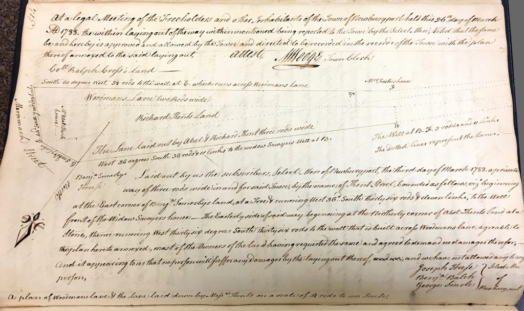
Drawing of Kent Street from the Newburyport Records 1764-1789, year 1788, Courtesy of the Newburyport Archival Center

Drawing of Kent Street from the Newburyport Records 1764-1789, year 1788, Courtesy of the Newburyport Archival Center

Drawing of Kent Street from the Newburyport Records 1764-1789, year 1788,  Courtesy of the Newburyport Archival Center

“The pleasant locations upon the higher land away from the river were not desired or could not be obtained. The opening of Kent and the new streets above started an interest in real estate that lasted until the time of the war of 1812.

“In 1800 Olive lane and Kent Street ran from Merrimac to High. (Ash Lane and Merrill lane, the present Russia Street) No other lanes were open in the whole tract of land from Merrimac to High and from Olive to Kent streets.” **^

203 High Street, was built in 1774, it was owned by John Lowell, and is known as the Lowell-Tracy-Johnson House.

201 High, the Jackson-Dexter House (Lord Timothy Dexter) was built in 1771 and is near what is now Dexter Lane.  

At that time 201 and 203 High were probably on the edge of Newburyport, the rest of High Street being trees, farms and the occasional slaughtering house for farm animals. 203 High Street is just at the edge of where the roadway widens. 

The town records discuss what is then Woodman lane (a version of what is now Kent Street) in 1765,  the comments appear to be pretty critical of the effort by the town of Newbury to create Woodman lane – “it is of no use to the town,” “but as it is now esteemed to be none (no service to the town).” ***^

In 1765 the selectmen recommend a new road, however, Kent Street did not get built until 1787-1788, twenty years later (things took time to get accomplished back then as well apparently.) ***^

Sharon Spieldenner found a map from 1807 that shows the widening around Buck and Kent Street.
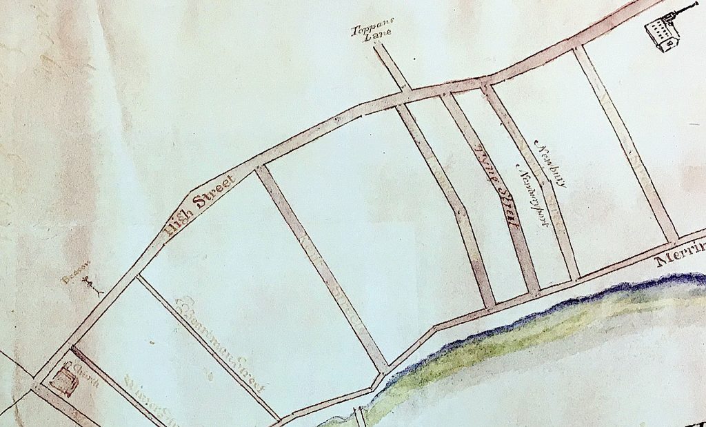
Detail of a 1807 map that shows the wide part of High Street, Courtesy of the Newburyport Archival Center

Detail of a 1807 map that shows the wide part of High Street, Courtesy of the Newburyport Archival Center

Detail of a 1807 map that shows the wide part of High Street, Courtesy of the Newburyport Archival Center

218 High Street, now on the corner of Buck and High was built in 1797 by Captain John Buck. Buck Street was created in 1800, it sits right at the edge of the existing street right where the roadway begins to widen.
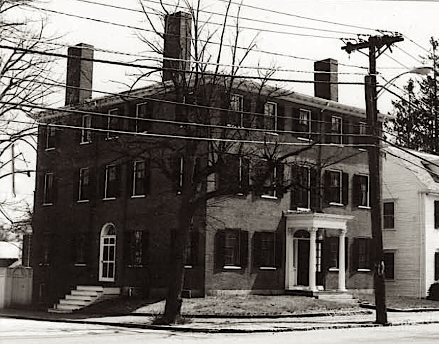
218 High Street, Newburyport MA

218 High Street, Newburyport MA

218 High Street, Newburyport MA

209 High Street, now on the corner of Johnson and High, was built in 1806 also sits on the edge of where the roadway is now. So it appears that we have at least circumstantial evidence that High Street was wide in that area as early as 1797 – 1806, over 2 centuries ago. 
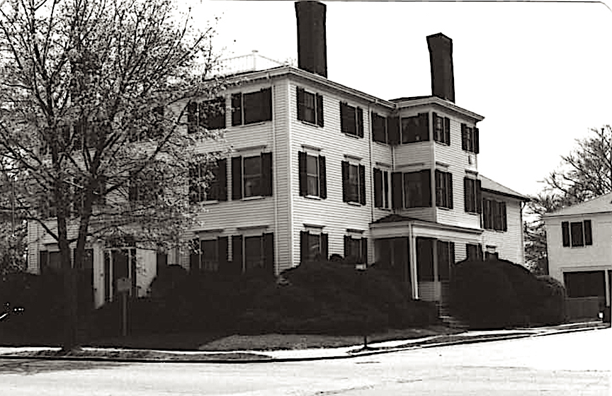
209 High Street, Newburyport MA

209 High Street, Newburyport MA

209 High Street, Newburyport MA

The wide part of High Street and 213 and 223 High Street from today’s city map.
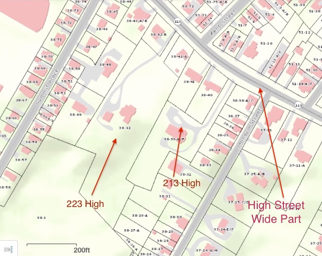
The wide part of High Street and 213 and 223 High Street from today’s city map. 
The wide part of High Street and 213 and 223 High Street from today’s city map.

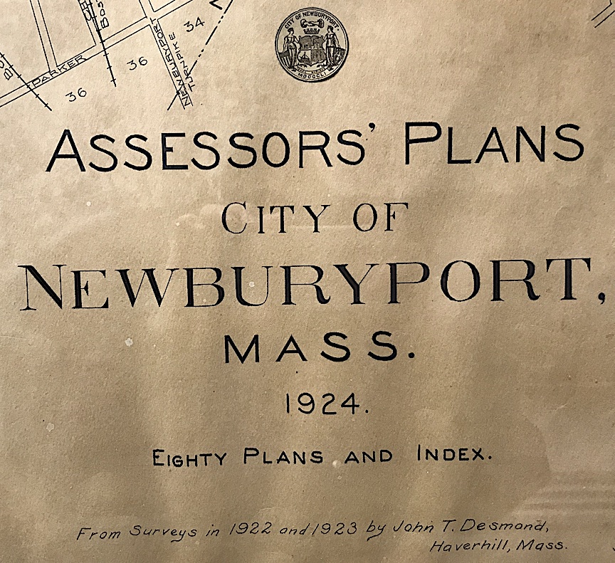
1924 Assessors Map

1924 Assessors Map

1924 Assessors Map showing the wide part of the road and 213 and 223 High Street
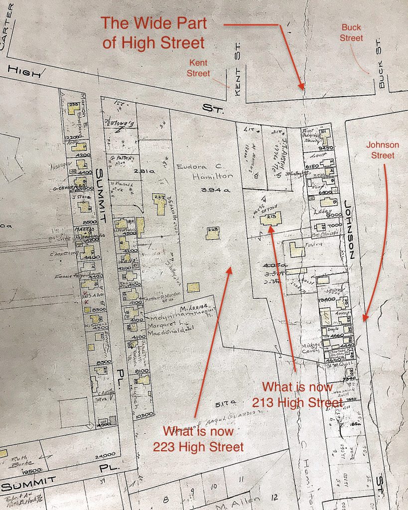
1924 Assessors Map showing the wide part of the road and 213 and 223 High Street

1924 Assessors Map showing the wide part of the road and 213 and 223 High Street

Survey from 1961 of 213 High Street, showing the wide part of the road.
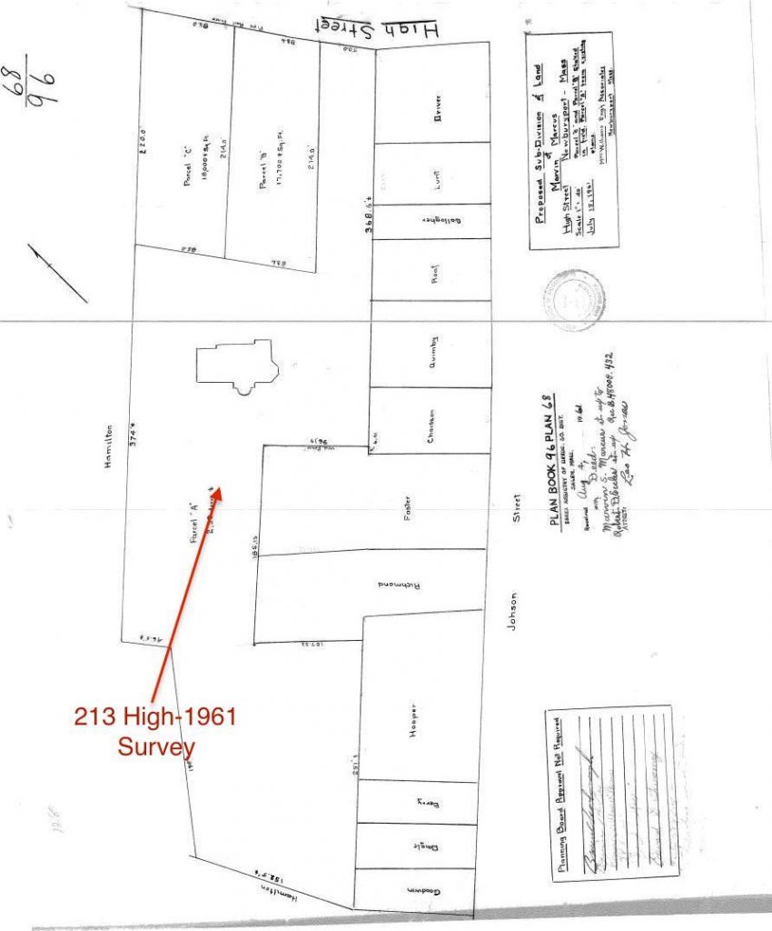
Survey from 1961 of 213 High Street, showing the widen part of the road.

Survey from 1961 of 213 High Street, showing the wide part of the road.

In 1857 there is a survey of what is now 213 and 223 High Street. The land fits perfectly into the land lots (that have now been partially broken up) that exist in today’s city’s map. It shows the angle of the roadway exactly as it is today. So we have absolute proof that High Street was wide in that area for 150 years. (Carrie Keville from the Newburyport Assessor’s Office helped me find the survey.)

Survey from 1857 of what is now 213 and 223 High Street that proves that the roadway was as wide as it is today.
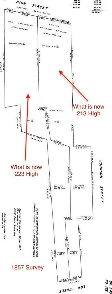
Survey from 1857 of what is now 213 and 223 High Street that proves that the roadway was as wide as it is today. 

Survey from 1857 of what is now 213 and 223 High Street that proves that the roadway was as wide as it is today.

This is a topographical map from the city that I’ve “tweaked” and  shows how the “brook” could have gone down the bottom of 213 High and/or Johnson Street, down what is now Kent Street causing the “gully” as well as possibly down  what is now Buck and Olive Streets. It is a theory as to why that part of the roadway may be extra wide in that particular spot. 

Topographical map showing the area around Bunk, Johnson and Kent Streets
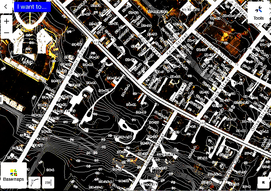
Topographical map showing the area around Buck, Johnson and Kent Streets 

Topographical map showing the area around Buck, Johnson and Kent Streets

It appears that High Street has been wide at Buck, Johnson and Kent Streets for at least 150 years, and it also appears that the street could have been that wide in that particular area for two centuries. 

*An Informal History of the Downtown Streets of Newburyport 1972,  Section on High Street by Josephine P. Driver, Page 131.

(“Josephine P. Driver (1893-1983), one-time curator of the Historical Society of Old Newbury, reminiscences about her childhood memories of her uncle, Elisha P. Dodge, a well-known Newburyport mayor and businessmen, published in Captains, Clams, and Cobblestones, 1977. Her father, Henry B. Little, was a long-time president of the Institution for Savings bank. Mrs. Driver was one of the many citizens and driving forces who advocated for the historic restoration of Newburyport’s downtown during the 1960s.” – Clipper Heritage Trail – Ghee Woodworth)

** John J. Currier, The History of Newbury, Mass.,1635 – 1902, Pages 414 -415

*** John J. Currier, History of Newbury, Mass., 1635 – 1902,  Page 342

**** John J. Currier, History of Newbury, Mass., 1635 – 1902,  Page 342

*^ North End Paper 1618 – 1880, Newburyport, Massachusetts: Development of the North End of the City, by Olive Bl Merrill, Transcribed by Margaret Pecham Motes, Pages 81 and 82. 

**^  North End Paper 1618 – 1880, Newburyport, Massachusetts: Development of the North End of the City, by Olive Bl Merrill, Transcribed by Margaret Pecham Motes, Page 110.

***^ Newburyport Records 1764-1789,  year 1765, Vol 1, page 38 

**^^  John J. Currier, The History of Newbury, Mass.,1635 – 1902, Footnote, Page 90

*^* The Safe Streets to School project is the incentive for the narrowing of this particular area of High Street. As I understand it the goal is that the “overall safety benefits should be considered in balance with historical objectives.”

Editor’s Note – Kent Street:

Woodman’s Lane,  now Kent Street, was probably laid out as early as 1675. In the Newburyport Records 1764-1789 Vol 1, page 38, there is a mention of “an agreement between Colonel Kent, Mr Woodman and the selectman,” the dates that are given for this agreement are 1722/23. It appears that over the years the town was struggling with this part of what is now lower Kent Street, and that the opinion in 1765 is that the road that was created around 1723 was “of no use to the town.“  *^^* 

The two drawings below are what lower Kent Street – then a combination of Woodman’s Lane and Merrill Lane, which was trying to negotiate around the gully, once looked like.  

Here are two images from the Newburyport Records 1764-1789, Vol 1, page 222, courtesy of the Newburyport Archival Center
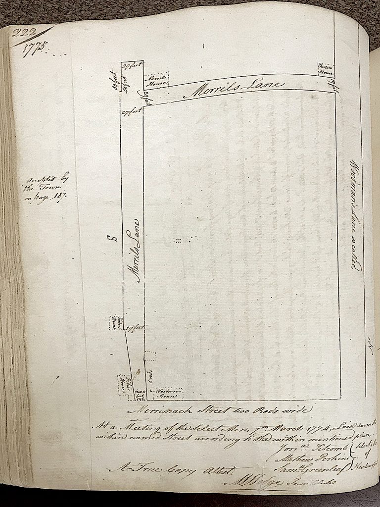
Map of Wood’s Lane and Merrill Lane 1775 from the Newburyport Records 1764-1789, Vol 1, page 222, courtesy of the Newburyport Archival Center

Map of Wood's Lane and Merrill Lane 1775 from the Newburyport Records 1764-1789,  year 1775, Vol 1

Map of Wood’s Lane and Merrill Lane 1775 from the Newburyport Records 1764-1789,  year 1775, Vol 1

Detail of the map of Wood’s Lane and Merrill Lane,  from the Newburyport Records 1764-1789,  year 1775, Vol 1, page 222, courtesy of the Newburyport Archival Center
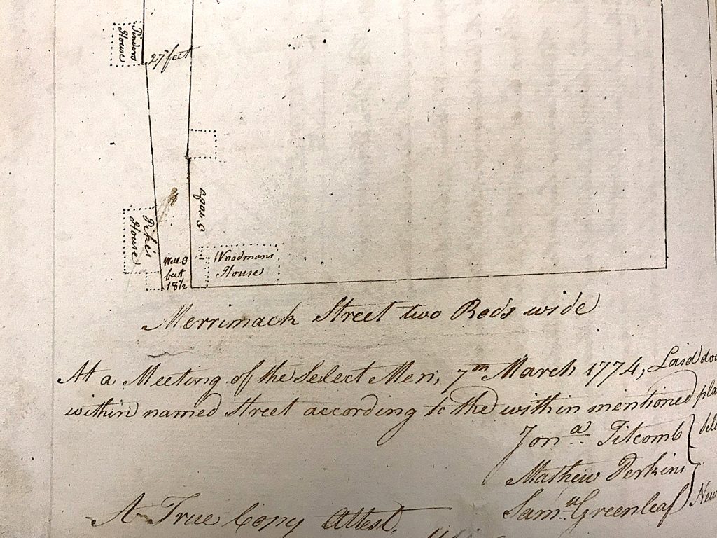
Detail of the map of Wood's Lane and Merrill Lane 1775 from the Newburyport Records 1764-1789,  year 1775, Vol 1.

Detail of the map of Wood’s Lane and Merrill Lane 1775 from the Newburyport Records 1764-1789,  year 1775, Vol 1.

And from the survey of Kent Street in 1788 it looks like lower Kent Street was completely re-configured, moving the entire lower part of the roadway north of the existing street. 

Detail of the survey of Kent Street in 1788, it looks like lower Kent Street was completely re-configured, moving the entire lower part of the roadway north of the existing street. *^*^ 
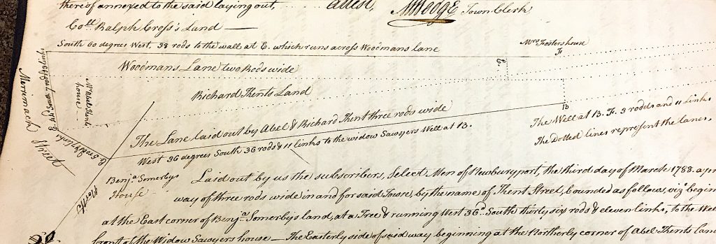
Detail of the survey of Kent Street in 1788, it looks like lower Kent Street was completely re-configured, moving the entire lower part of the roadway north of the existing street. 

Detail of the survey of Kent Street in 1788, it looks like lower Kent Street was completely re-configured, moving the entire lower part of the roadway north of the existing street.

*^^* John J. Currier, History of Newbury, Mass., 1635 – 1902,  Page 344

*^*^ Detail of the drawing of Kent Street from the Newburyport Records 1764-1789, year 1788, courtesy of the Newburyport Archival Center.

Editor’s Note:

This is a detail of really early map courtesy of Sharon Spieldenner of the Newburyport Archival Center. A guess on the date might be around 1720.
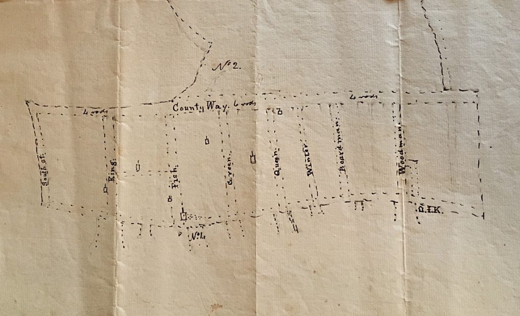
A detail of a really early map courtesy of Sharon Spieldenner of the Newburyport Archival Center. A guess on the date might be around 1720.

A detail of a really early map courtesy of Sharon Spieldenner of the Newburyport Archival Center. A guess on the date might be around 1720.

A detail of a really early map courtesy of Sharon Spieldenner of the Newburyport Archival Center. A guess on the date might be around 1720.

This is a theory/guess by Rick Taintor as to why the High Street is so wide between Kent and Buck Street. 

“The road was laid out at a specific width, but probably wasn’t engineered with curving sidelines.  I’ve drawn two pairs of straight lines representing a theoretical original layout, meeting at an angle just west of Johnson Street.

However, the early users probably cut corners, especially when pulling wagons rather than just riding horses, and particularly where no development had yet occurred. Over time, the actual roadbed could have shifted to a smooth curve between Kent and Johnson, so the traveled way might have moved out of the original sidelines.  At some later date, the angle of the sideline on the north side of the road could have been adjusted to ensure that the right of way encompassed the traveled way.”

A drawing of a theory of why the High Street is so wide between Kent and Buck Street.
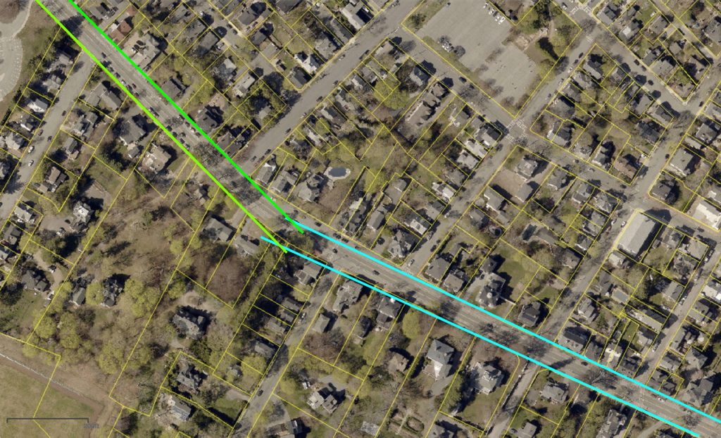
A drawing of a theory of why the High Street is so wide between Kent and Buck Street.

A drawing of a theory of why the High Street is so wide between Kent and Buck Street.

From John J. Currier “History of Newburyport, Mass: 1764 – 1905” Vol I, page 22, the map was drawn in 1795 but represented Newburyport in 1764. High Street bends at Woodman’s lane. Reproduced from the Massachusetts Archives (Town Plans, vol II., Part I.)
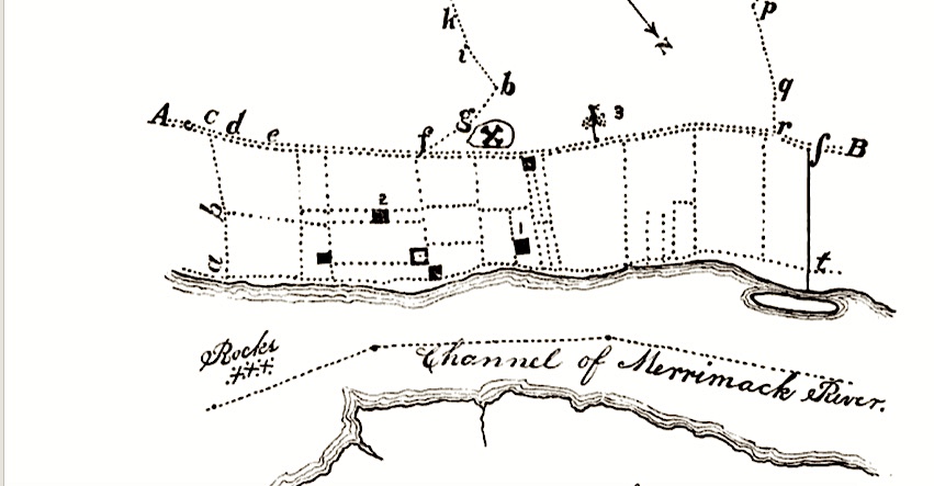
From John J. Currier “History of Newburyport” Vol I page 22, the map was drawn in 1795 but represented Newburyport in 1764. High Street bends at Woodman's lane.

From John J. Currier “History of Newburyport” Vol I page 22, the map was drawn in 1795 but represented Newburyport in 1764. High Street bends at Woodman’s lane.
More Posters for Newburyport’s “If This House Could Talk -2018”

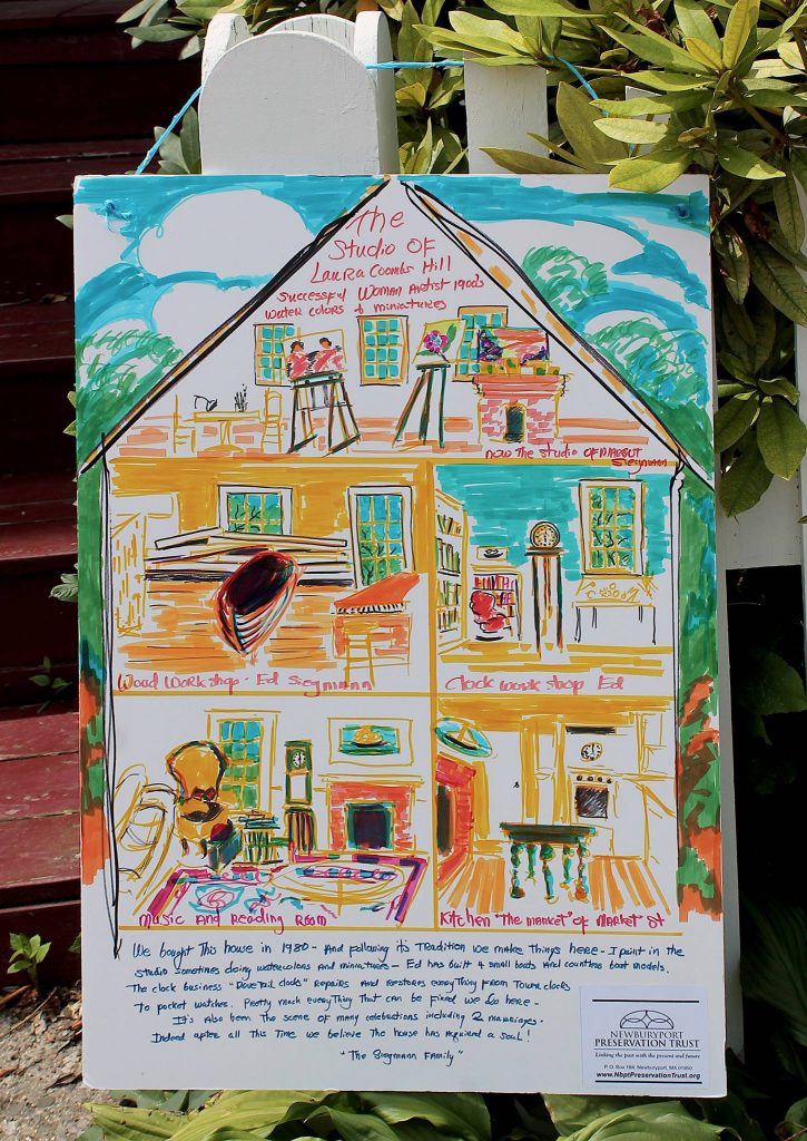
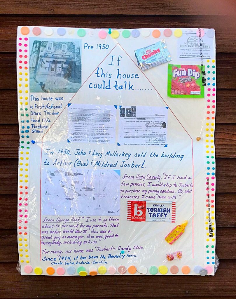
Here are a few more posters from this year’s Newburyport “If This House Could Talk – 2018”

89 – 91 High Street

89-91 High Street, Newburyport, poster for "If This House Could Talk -2018"

89-91 High Street, Newburyport, poster for “If This House Could Talk -2018”

“If This House Could Talk is a community based history and public art project, first created and produced by residents of the Cambridgeport section of Cambridge, Massachusetts. The concept is to collect and present local history, and historical anecdotes, through a collaborative activity in which residents and businesses post hand written signs and graphics in front of their homes and businesses telling stories and offering information from the recent or not-so-recent past. 

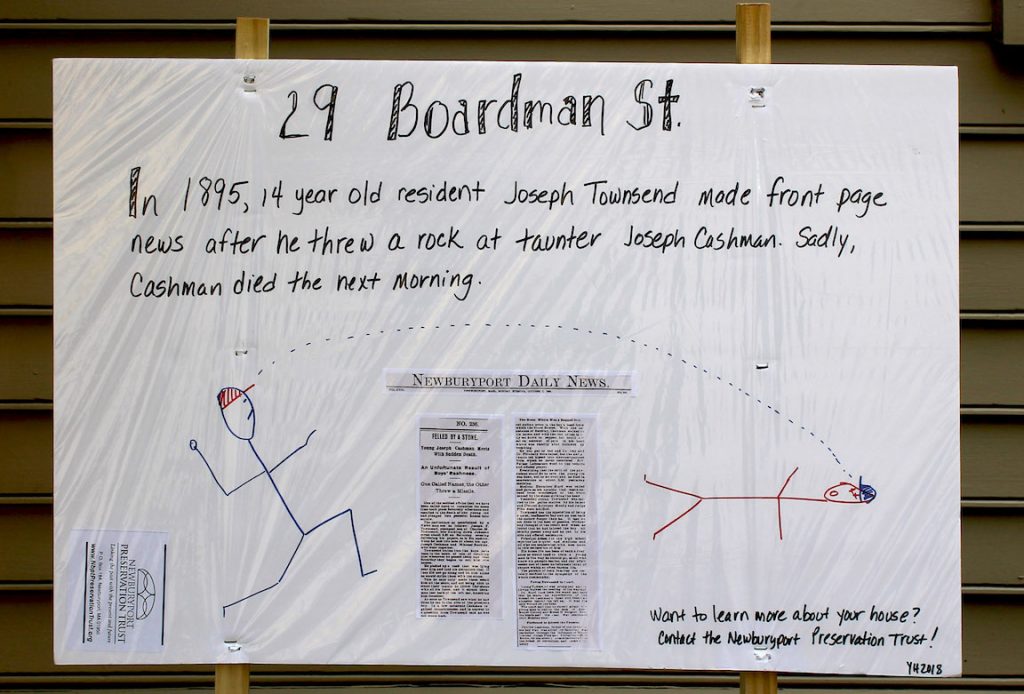
29 Boardman Street

29 Boardman Street, Newburyport, poster for "If This House Could Talk -2018"

29 Boardman Street, Newburyport, poster for “If This House Could Talk -2018”

In community settings the signs posted for outdoor view present a range of information from the architectural history of a specific building or part of the neighborhood, to personal experiences and stories of the current or historic residents of a particular house. 

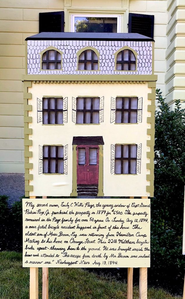
88 High Street

88 High Street, Newburyport, poster for "If This House Could Talk -2018"

88 High Street, Newburyport, poster for “If This House Could Talk -2018”

Public projects like If This House Could Talk offer neighborhood residents a way to present historical information with a personal voice. This type of free and accessible presentation of information in public places encourages walking and exploration of a neighborhood in order to discover and learn from the signs and artworks. Sharing of local history may bring a community together through the engagement with common stories and sharing of values, and contribute to building a sense of place. An increased appreciation for historical preservation is also a byproduct of the event.”

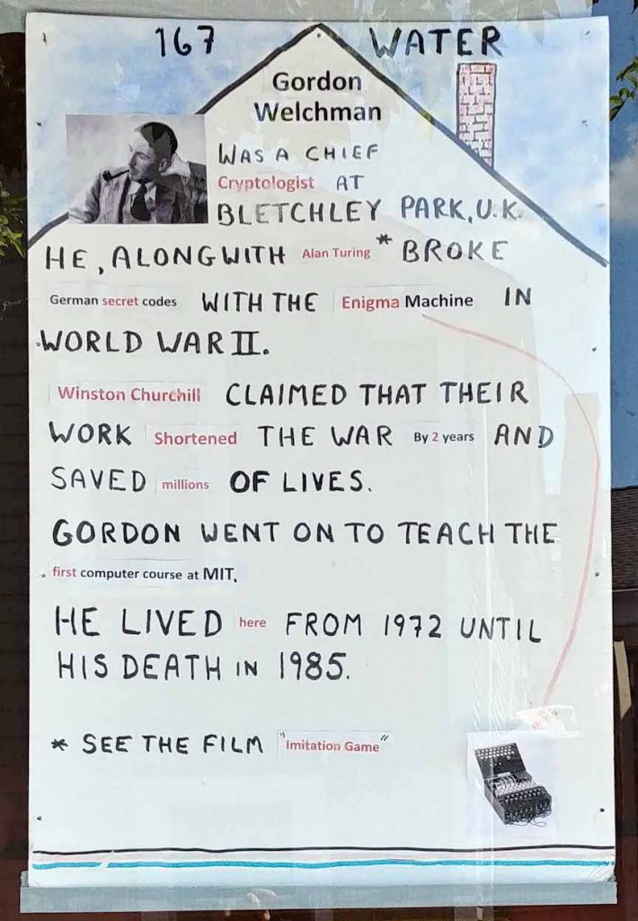
167 Water Street

167 Water Street, Newburyport, poster for "If This House Could Talk -2018"

167 Water Street, Newburyport, poster for “If This House Could Talk -2018”

From Wikipedia, If This House Could Talk: https://en.wikipedia.org/wiki/If_This_House_Could_Talk 

Newburyport If This House Could Talk-2018, So Many Great Posters

All the posters that folks made for “If This House Could Talk – 2018” are terrific, it is very hard to pick ones to share on The Newburyport Blog. But here are a few more.

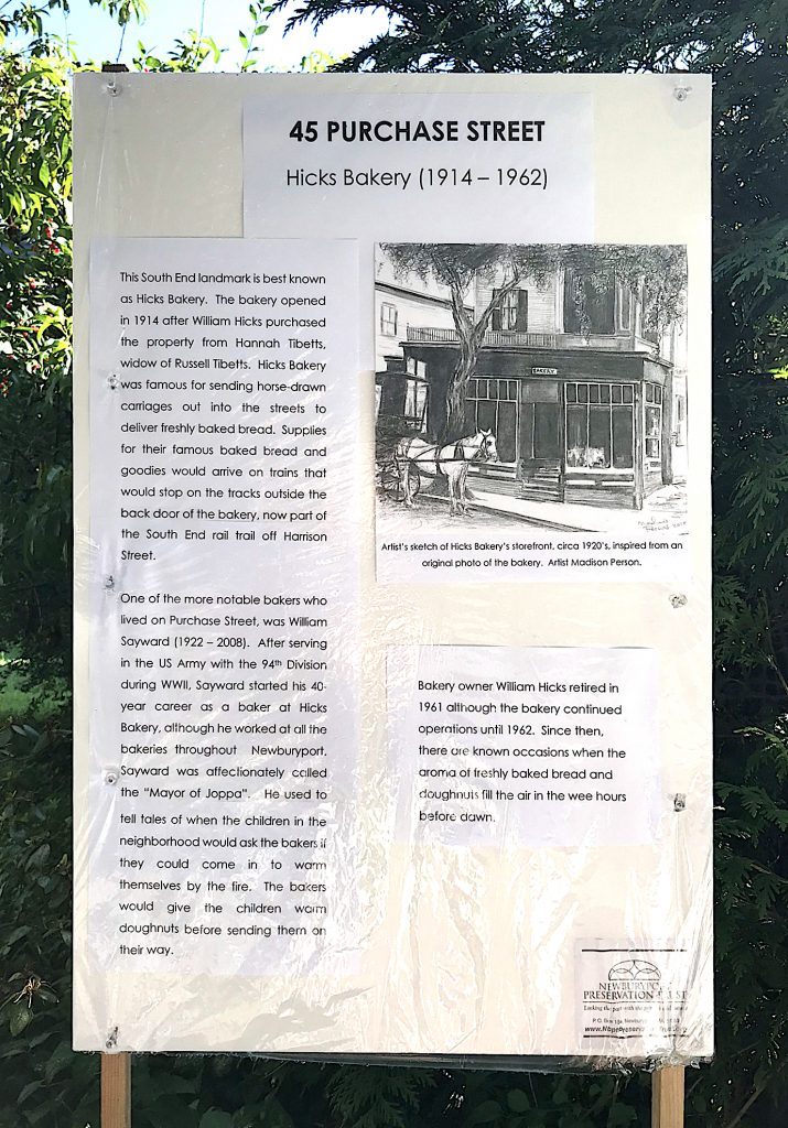
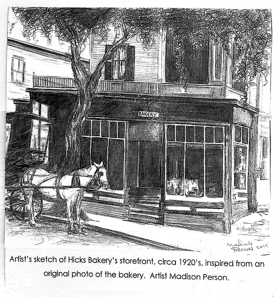
45 Purchase Street, Hicks Bakery, Newburyport

45 Purchase Street, If This House Could Talk - 2018

45 Purchase Street, If This House Could Talk – 2018

Drawing of what 45 Purchase Street in Newburyport, then known as Hicks Bakery, looked like around 1920.

What 45 Purchase Street, then Hicks Bakery, looked like around 1920.

What 45 Purchase Street, then Hicks Bakery, looked like around 1920.

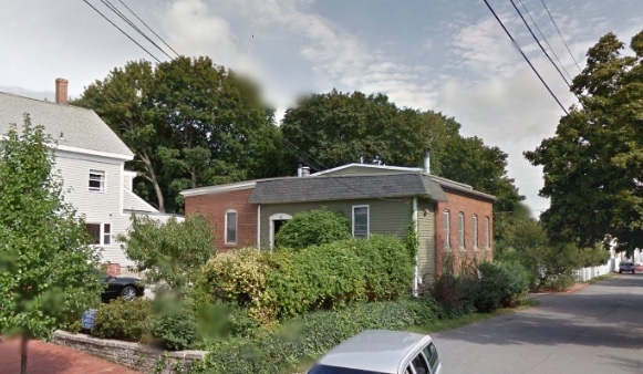
What 45 Purchase Street looks like today

45 Purchase Street, Newburyport in 2018

What 45 Purchase looks like today

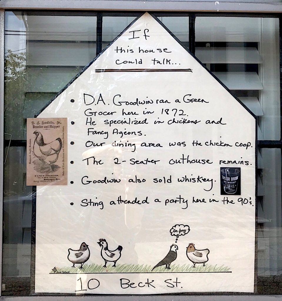
10 Beck Street, Newburyport

10 Beck Street, If This House Could Talk - 2018

10 Beck Street, If This House Could Talk – 2018

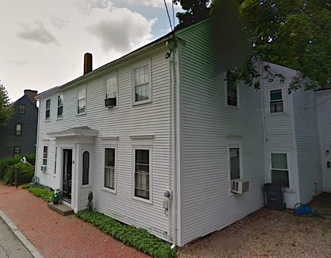
10 Beck Street, Newburyport, today.

10 Beck Street, Newburyport, today

10 Beck Street, Newburyport, today

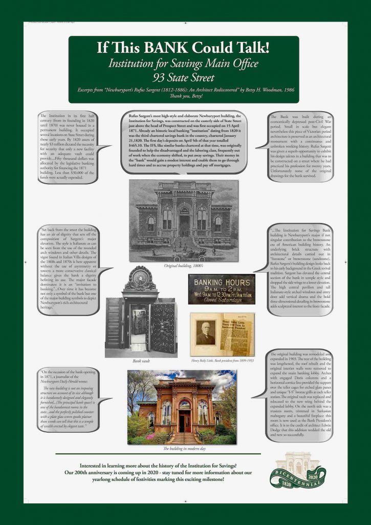
93 State Street, the Institution for Savings

93 State Street, the Institution for Savings, If This House Could Talk - 2018

93 State Street, the Institution for Savings, If This House Could Talk – 2018

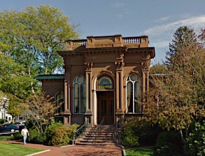
93 State Street, the Institution for Savings, is as beautiful today as when it was built.

93 State Street, Newburyport, today

93 State Street, Newburyport, today

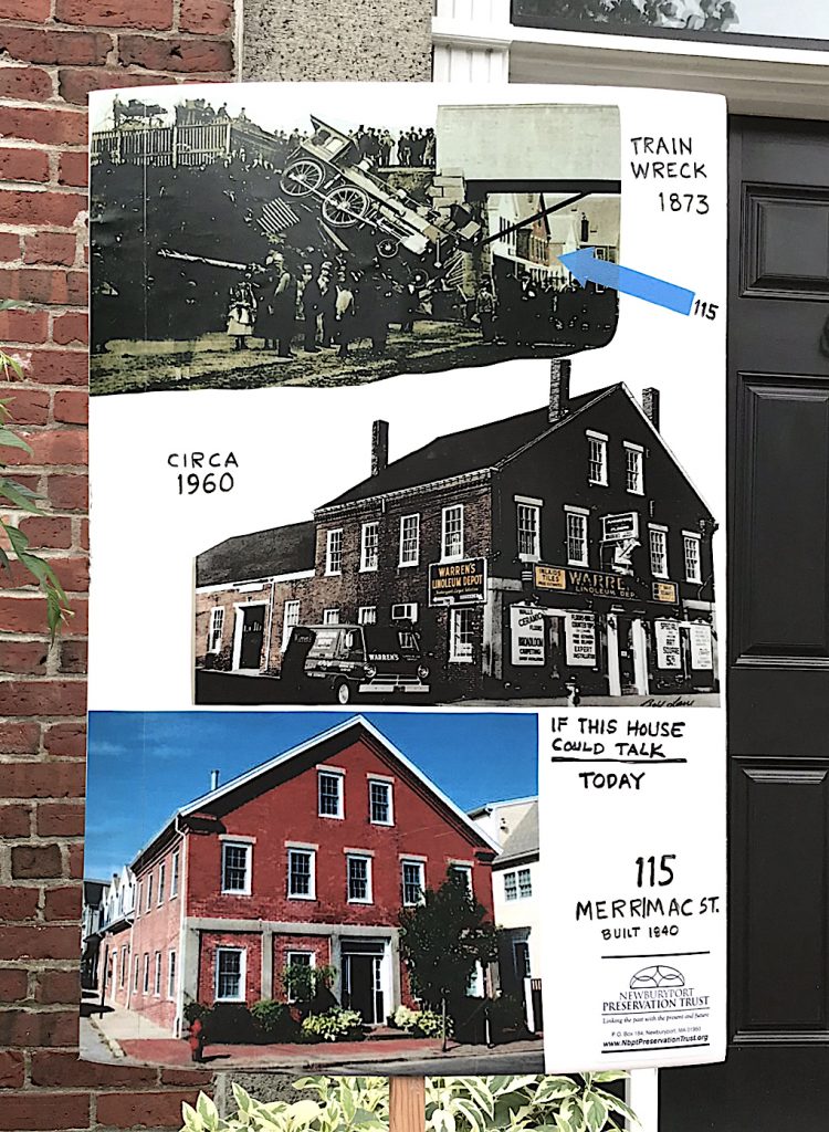
115 Merrimac Street

115 Merrimac Street, If This House Could Talk - 2018

115 Merrimac Street, If This House Could Talk – 2018

The poster for 115 Merrimac Street in Newburyport tells the story, its history and what it looks like today.

To see the complete album for “If This House Could Talk – 2018” go here.

This link also works to see the album.

And please visit the “If This House Could Talk” Facebook page.

Newburyport “If This House Could Talk-2018”

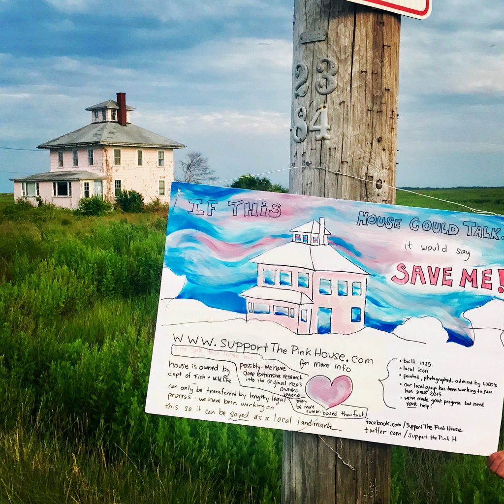
Newburyport’s “If This House Could Talk” is in its 3rd year, and what a hit it is. Here are four of the posters of more than 100 that are all around town.

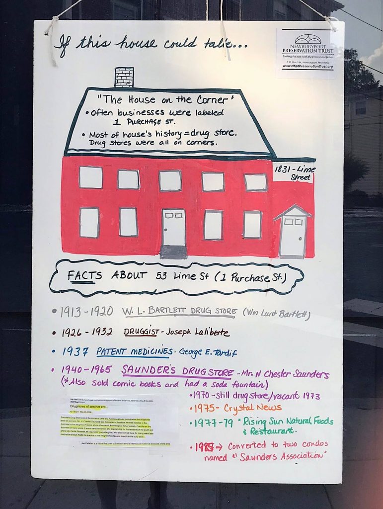
1 Purchase Street

1 Purchase Street, poster for Newburyport, If This House Could Talk-2018

1 Purchase Street, poster for Newburyport, If This House Could Talk-2018

19 Washington Street

19 Washington Street, poster for Newburyport, If This House Could Talk-2018

19 Washington Street, poster for Newburyport, If This House Could Talk-2018

39 Franklin Street

39 Franklin Street, poster for Newburyport, If This House Could Talk-2018

39 Franklin Street, poster for Newburyport, If This House Could Talk-2018

The Pink House

The Pink House, poster for Newburyport, If This House Could Talk-2018

The Pink House, poster for Newburyport, If This House Could Talk-2018

The entire album of this year’s posters can be seen here.

And please visit the website for If This House Could Talk – Newburyport.

If This House Could Talk – Newburyport is sponsored by the Newburyport Preservation Trust.

The album can also be seen here.

10 Residential Units at the Brown School Would Make the Neighborhood Feel a Whole Lot Better

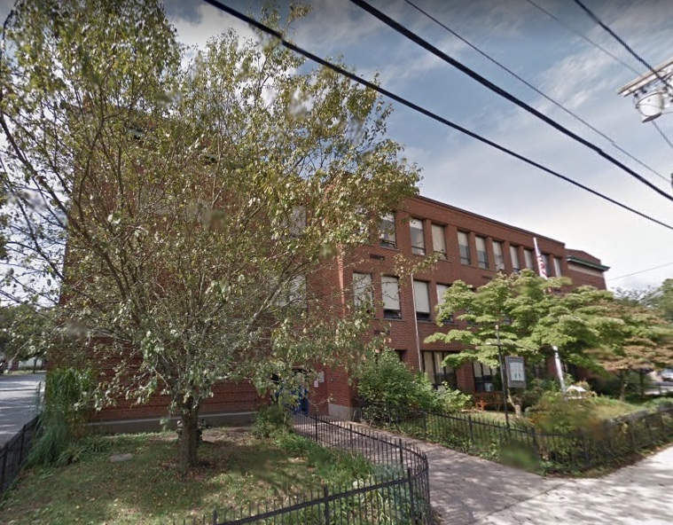
The Brown School

The Brown School

The Brown School, Newburyport

I’ve been scratching my head as to where in the world the push for 27-29 affordable senior housing units came from for the Brown School, which is a complete about face from the direction that the City had been going for as re-use for that property.

It has come from good folks in Newburyport.

And from someone who lives in the Brown School neighborhood 27-29 units of any size is nuts.  This is one of the most densely populated areas of the city with narrow 18th century streets. On street parking is already a nightmare, we already have what I call “neighborhood road rage” when it comes to parking and traffic.

The temperature in the neighborhood would go down a whole lot if the proposal was for 10 residential units. That’s realistically 20 cars. And if the neighborhood got to have the Newburyport Youth Services (NYS) stay, that would be a big extra bonus.

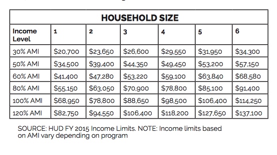
There are a variety of different affordable categories which are referred to as Affordable Medium Income (AMI). Here is table from a 2015 household study from Boston, Newburyport is considered part of the Boston Hud Federal  Management Regulation (FMR) area.

2015 Affordable Medium Income (AMI)

2015 Affordable Medium Income (AMI)

2015 Affordable Medium Income (AMI)

As you can see there are different percentages of the AMI, 30%, 50%, 60%, 80%, 100% and 120%.

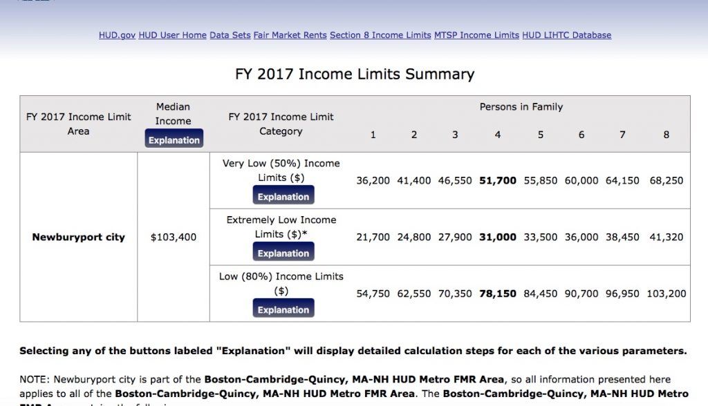
According to HUD the Medium Income for Newburyport in 2017 is $103,000. This table show 50%, “Extremely Low” and 80%.

Newburyport 2017 AMI

Newburyport 2017 AMI

Newburyport 2017 AMI

If the City put out a Request For Proposal (RFP) for 10 units, they could be half market rate and half affordable, or all affordable at let’s say 5 different levels of AMI (that’s the % of income) if funding could be found for different AMI levels in the same building. I think under scenarios along these lines that most of the neighborhood would be breath a sigh of relief.

Newburyport Youth Services (NYS)

Newburyport Youth Services (NYS)

Newburyport Youth Services (NYS)

And my understanding is that there is no place for NYS to go even if there was funding. My impression was that NYS did not want to be in the building or the neighborhood, but that’s not the case at all — they love where they are. I thought NYS had somewhere they could go, but apparently that is not the case.

Councilor Jared Eigerman’s Ordinance now in front of the City Council is a wonderful starting place.  I hope we can get to a place where NYS, affordable housing folks and the neighborhood are not pitted against each other, but where we can all come together and find a solution that has something for everyone and not everyone gets everything they want – that’s what I call good negotiating.

Editor’s Note:

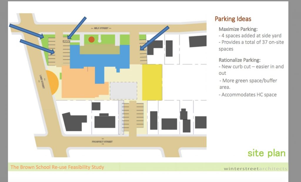
This is from the 2014 Brown School Feasibility Study. There are 37 available parking spaces. If there were 10 units, that would realistically be 20 cars and 17 left over parking spaces. The basketball court at the Brown School Park and possibly parts of the Brown School Park itself could be used for snow emergency parking for the neighborhood along with those extra 17 spaces.

Brown School Parking from the 2014 Feasibility Study

Brown School Parking from the 2014 Feasibility Study

The Re-Use of the Brown School

The Community Coming Together Working on the Brown School Park, September 2013.

The Community Working on the Brown School Park, September 2013

The Community Working on the Brown School Park, September 2013

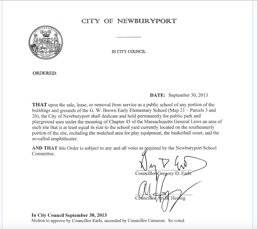
In 2013 the city rallied to protect the Brown School Park after the Brown School was decommissioned. The neighborhood desperately wanted to at least keep some of the community feeling that the Brown School created. Citizens worked really hard on a petition drive to protect the Brown School Park. And on September 30, 2013 the Newburyport City Council passed an Order that protects about 10,000 square feet of the Brown School for a park in perpetuity, it was then approved by the Newburyport School Committee.

The 2013 Order to protect the Brown School Park

The 2013 Order to protect the Brown School Park

The 2013 Order to protect the Brown School Park

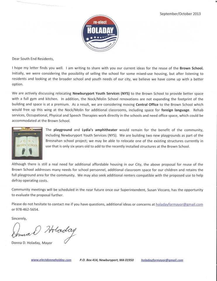
In the fall of 2013 Mayor Donna Holaday reassured the South End that the Brown School would not be closed, “we were considering the possibility of selling the school for some mixed-use housing, but after listening to residents and looking at the broader school and youth needs of our city, we believe we have come up with and better option.” Mayor Holaday’s words, not mine.
Mayor Holaday’s 2013 Letter

Mayor Holaday’s 2013 Letter Not to Sell the Brown School

Mayor Holaday’s 2013 Letter Not to Sell the Brown School

In 2014 the City spent $40,000 on the Brown School Feasibility Study *, which is excellent. However it does point out that in 2014 the Brown School and the land is worth over $5 million * (it has recently been appraised at $5.8 million) and the cost in 2014 to develop/fix the Brown School is close to $14 million — that’s a total of $19-20 million dollars *, that’s a lot of money.

This year, just recently the mayor did a complete about face. In the Thursday January 25th meeting the mayor said that the Newburyport Youth Services (NYS) would be removed from the building *** (the Brown School neighborhood loves having the NYS there **) and the building would be used for all affordable housing. In my opinion that is nuts given the density of the neighborhood and the parking and traffic issues.
To my dismay, what now seems to be happening is that the neighborhood and the Brown School Park are now pitted against the affordable housing folks which is awful. We want to work together to meet all the needs, not have the community divided against each other.

These are Links to:

The Brown School Re-Use Updates

* The Brown School Re-Use Feasibility Study 10/30/14

**The Public Comments (which are very favorable) to the draft of the feasibility study and options as of 11/18/14

*** From an email from the Director of Youth and Recreation Services, Newburyport Youth Services (NYS), February 1, 2018

“Dear NYS Friends and Families,

It was announced last Thursday at a public meeting that NYS will no longer be part of the re-use proposals for the Brown School. The plan, as of now, is that the City hopes to move forward with a Request for Proposals (RFP) to developers focused on creating affordable housing. At the meeting, the Mayor did state the City may retain the gymnasium (to be overseen by NYS) and then find, buy, lease or build a new space for NYS.”

Meetings that Push Agendas Rather than have Thoughtful Critiques — Recently the Reuse of the Brown School

Push an agenda

Last year I worked on a national level to save the Affordable Care Act (ACA) from Republican repeal efforts. It was fascinating and not unlike local politics. And my experience in local politics helped me emotionally navigate this new political terrain.

I joined up online with a bunch of folks at Vox.com, the group is called “A Community for Obamacare Enrollees by Vox.com.”  And one of the things we did was organize people to go to Capital Hill for committee meetings on health care. I watched a ton of meetings on Capital Hill, and my frustration was immense. The meetings by the Republicans in February 2017 were completely choreographed to produce a result that promoted their agenda, it wasn’t about an honest discussion at all. Later in the year, there was actually a great series of health care committee meetings, and they were completely different. Everyone on both sides of the aisle listened to a variety of witnesses with very different viewpoints. They were rational, constructive and very informative and a really good example of governing. I was really impressed.

In Newburyport we are not immune from meetings that are what I call “push agenda meetings,” that have a specific end goal in mind and are not an open discussion of different possibilities and options. The first one I went to was a sub-committee on plastic bags, it was a nightmare, the process was so bad that I blogged about it.

I remember writing that the meeting seemed to me to be more about a homily to a plastic bag ban, than a how could we problem solve this together as a community. It was stacked with anti-plastic bag folks from Newburyport as well as folks from as far away as Boston.  There was a woman at that meeting, not from Newburyport, who had the gall to say that plastic bag lobbyists lived among our wards and were giving bribes to our city councilors – which was absolutely nuts. Did the folks who were running the meeting, who were City Councilors, bat an eye. No they did not. And any suggestion of having a nuanced approach was shouted down by people in the meeting. The meeting was completely out of control. I vowed I would never, ever go to a Newburyport civic meeting again. But I did.

I went to the public meeting on the 40R, it was a joint meeting with the City Council and the Planning Board. I had a lot of questions about the 40R and so did a lot of folks. My impression was that the meeting was stacked in favor of the 40R (and later a City Councilor quite proudly told me that yes indeed, the meeting was stacked in favor of the 40R, they made sure that it was). Lots of folks spoke in favor of the 40R and were warmly received. Anyone with questions, were dismissed. I walked out. Friends of mine who went, who had lots of very smart reservations about the 40R, asked me what was going on, they could not believe it. Unfortunately I said they were right. Any sort of practical or thoughtful critique of the 40R proposal was not part of the “agenda.”

The recent “neighborhood” meeting on the reuse of the Brown School was a stacked meeting for affordable housing. Anyone who knows me at all, knows that the fact that Newburyport has become so unaffordable really upsets me, and I am all for affordable housing with a big and small “A.” The meeting was not for the neighborhood to constructively discuss what to do with the Brown School and discuss what to do about affordable housing in Newburyport and at the Brown School. The meeting was to push an agenda for the Brown School by the current administration. I’ve been told that there were folks from outside the neighborhood (all well meaning) who showed up to speak in favor of all affordable housing for the Brown School, which is very different from what the city proposed in 2014And I’ve also been told that the neighbors who had reservations about the idea felt intimidated about speaking up. This surprises me not at all.

So, for the neighbors of the Brown School who would like a say in what happens (and it’s very complicated, I’m not saying it’s not), please email the mayor and all the Newburyport City Councilors with your thoughts, ideas and concerns. They will not be able to make an informed decision if they do not hear from you. The City Councilor’s contact information is here.

Push

Laroy S. Starrett – A Farmer, a Famous Business Man, an Inventor, whose First Patent was in Newburyport, MA

A friend of mine collects old tools and asked me to see what I could find out about Laroy Starrett and his time here in Newburyport, so I went on a hunt. And this is one fascinating gentleman.

Laroy Starrett, or L.S. Starrett as he eventually went by, was born in China, Maine in 1836. It’s possible that he came to Newburyport as early as 1855, but he definitely shows up on the 1860 Census. I found him listed as working for Mrs. Mary White Bannister Hale, the widow of Ebenezer Hale, at Mount Rural. He is listed as a farmer (and he was a very good farmer).

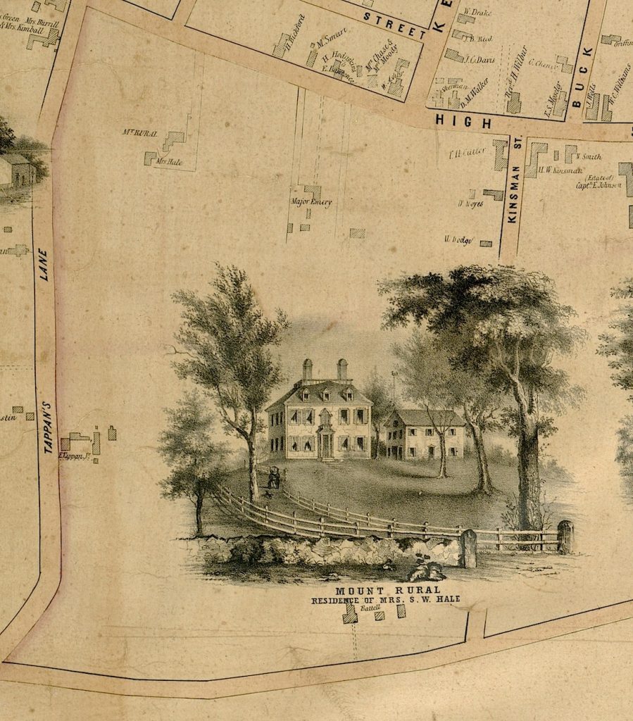
What is so cool is that in the 1851 map in the Archival Center at the Newburyport Library, there is a drawing of Mount Rural, the residence of Mrs. S.W. Hale, although it no longer exists today. And I can imagine young Laroy walking to the house looking for a job as a young man.

Mount Rural, Residence of Mrs. S.W. Hale, 1851 map of Newburyport

Mount Rural, Residence of Mrs. S.W. Hale, 1851 map of Newburyport

Mount Rural, Residence of Mrs. S.W. Hale, 1851 map of Newburyport

Mount Rural is where the Newburyport High School exists today, back then it was a little different.

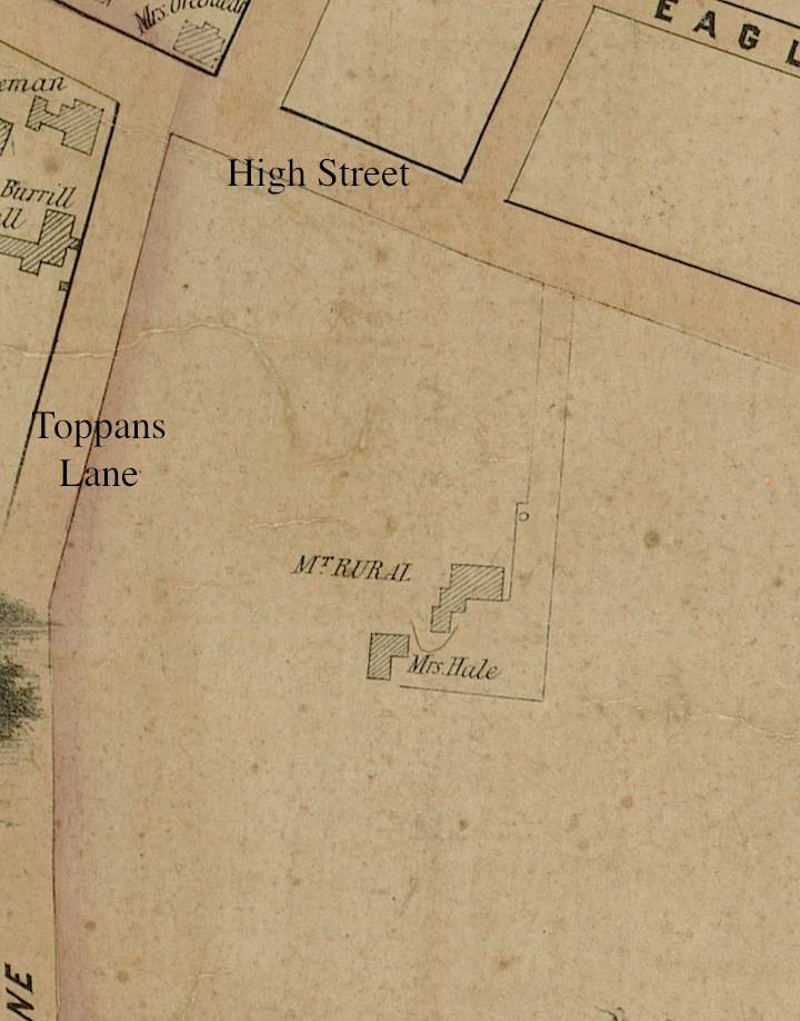
Here is the the 1851 map with the house and the land.

The 1851 map with the house and the land, Mount Rural, Residence of Mrs. S.W. Hale

The 1851 map with the house and the land, Mount Rural, Residence of Mrs. S.W. Hale

The 1851 map with the house and the land, Mount Rural, Residence of Mrs. S.W. Hale

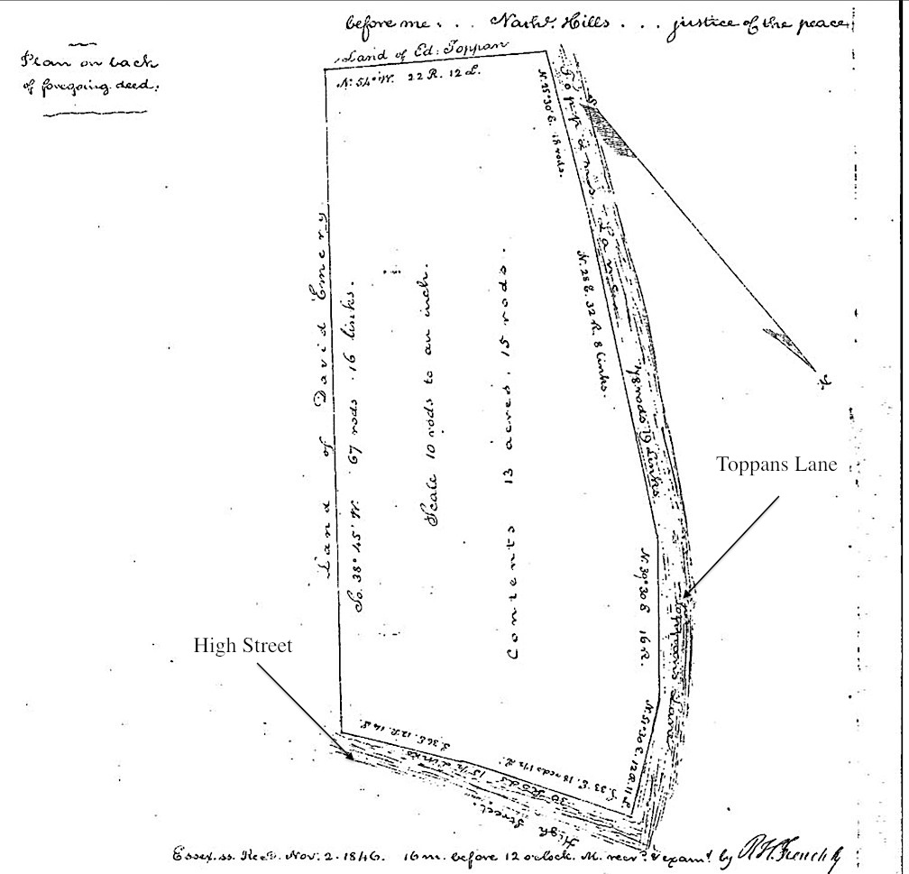
And here is an 1846 map of the land, Salem Deeds Online, Book 373, Page 211

1846 map of the land, Essex Deeds, book 373, page 211

1846 map of the land, Essex Deeds, Book 373, Page 211

1846 map of the land, Essex Deeds, Book 373, Page 211

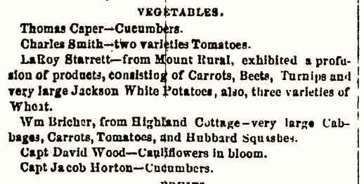
And there is a mention of him in the newspaper, “Laroy Starrett—from Mount Rural” and a list of the “profusion of products” that he exhibited, “Carrots, Beets, Turnips and very large Jackson White Potatoes, also, three varieties of Wheat.”

From a 1860 newspaper mentioning Laroy Starrett

From a 1860 newspaper mentioning Laroy Starrett

From a 1860 newspaper mentioning Laroy Starrett

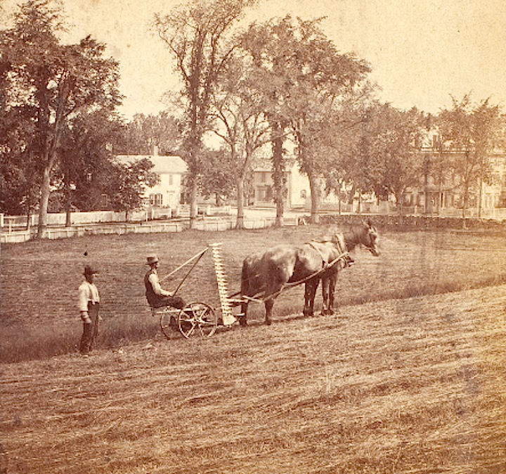
Historic New England has a wonderful photo of two men harvesting Mount Rural in 1880.

Two men harvesting Mount Rural in 1880, Courtesy of Historic New England

Two men harvesting Mount Rural in 1880, Courtesy of Historic New England

Two men harvesting Mount Rural in 1880, Courtesy of Historic New England

In 1861 Laroy married Lydia W. Bartlett, from Newburyport, her father and mother were Henry A. Bartlett and Hanna Bartlett. Lydia’s father is listed as a farmhand and her mother worked in one of the mills. I have this romantic image of how Laroy and Lydia might have met. When they lived in Newburyport they had three children. The 1865 Census lists Laroy as a farmer, married with two young children, Frank age three and Ada age one. Alice is born in Newburyport in 1867.

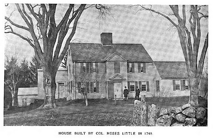
In the Newburyport City Directory, the Starretts are listed from 1864-1865 at “the little Turkey Hill farm.” What I am wondering is if Laroy was working or even at that point running the farm at Turkey Hill, which belonged to John Gardner Little. If so, the house exists to this day, it is 100 Turkey Hill Road. It was built by Colonel Moses Little of the Seventeenth Regiment in the Revolutionary War (John J. Currier and the Newburyport Historical Commission).
The house build by Colonel Moses Little in 1748, 100 Turkey Hill Road

The house build by Colonel Moses Little in 1748, 100 Turkey Hill Road

The house build by Colonel Moses Little in 1748, 100 Turkey Hill Road

L. S. Starrett is not known for his farming, he is known for his tools and as an inventor and as a very famous business man.

In 1866 the Starretts moved to 12 Tyng Street (lower Tyng Street near Merrimac Street), which could also be 16-18 Tyng Street, there is no way of knowing (the street numbers change over the years), but they moved from the farm into town, and that was because Laroy had invented a meat cutter in 1865.

16-18 Tyng Street and 12-14 Tyng Street

16-18 Tyng Street and 12-14 Tyng Street

16-18 Tyng Street and 12-14 Tyng Street

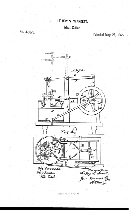
Here are the drawings for the patent.

The drawings of the 1865 meat cutter by Laroy Starrett

The drawings of the 1865 meat cutter by Laroy Starrett

The drawings of the 1865 meat cutter by Laroy Starrett

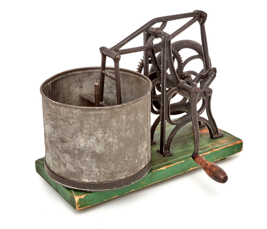
And here is one of the original meat cutters.

A meat cutter invented by Larry Starrett

A meat cutter invented by Larry Starrett

A meat cutter invented by Larry Starrett.

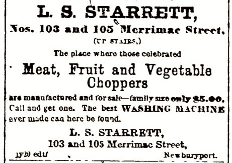
Laroy was making and selling the meat choppers at 103 and 105 Merrimac Street, which may well have been close to Tyng Street, or at least in walking distance . In 1867 and 1868 Laroy was advertising the meat cutter/chopper a lot in the local newspapers.

A 1868 advertisement for Laroy Starrett’s meat cutter

A 1868 advertisement for Laroy Starrett’s meat cutter

A 1868 advertisement for Laroy Starrett’s meat cutter

He was so successful that he left Newburyport to manufacture his inventions, which also included a washing machine and a butter worker, in Athol Massachusetts, which is in the upper western part of the state near Gardner.

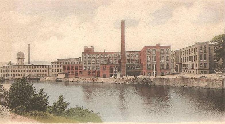
Today L.S. Starrett is a multi-million global company trading on the New York Stock Exchange, all sorts of amazing tools and instruments whose headquarters are still in Athol Massachusetts. It is still influenced by the family (which is pretty cool).

L. S. Starrett Manufacturing Company plant, Athol, Massachusetts, 1905

L. S. Starrett Manufacturing Company plant, Athol, Massachusetts, 1905

L. S. Starrett Manufacturing Company plant, Athol, Massachusetts, 1905

This is from the Worcester Business Journal, “Big Business, Doug Starrett,” by Christina Davis

“Douglas A. Starrett may run a large global business representing more than $220 million in annual sales, but his management style and demeanor is more akin to a manager of a small 20-person office.

As he walks the snaking halls of L.S. Starrett Co.’s monstrous 555,000-square-foot headquarters in Athol, he greets employees by name. Many employees – some who’ve worked at the company producing precision measuring tools for more than 30 years – stop to chat, and to gently chide the boss about his recent decision to shave off his beard. His annual letter to employees and retirees contains as much in the way of business updates as it does down-to-earth charm – including the score from the Thanksgiving Day Athol football game.

He’s equally at home setting up operations in some far-flung location halfway around the globe as he is approving name tags for a semi-annual employee meeting.

“We’ve got a big breadth and scope, but I like to think we operate as a small business,” Doug Starrett said.”

This is a pretty amazing legacy for a farmhand on Mrs. Hale’s estate, Mount Rural, Newburyport, Massachusetts.

The High Street Master Plan

State and High Street, Courtesy of the Newburyport Archival Center

State and High Street, Courtesy of the Newburyport Archival Center

In 1999 the City of Newburyport rallied to save High Street from plans by MassHighway, now MassDOT. More can be read about that on The Newburyport Blog’s page about Hight Street as well as the post on how High Street was almost destroyed in 1999.

In 2004 the city came up with the High Street Master Plan, however, the plan languishes in the Newburyport Planning Office.  People were so upset when the bike lanes went down that the mayor vetoed the High Street Master Plan and the Newburyport City Council did not have the votes to override the veto. Much later the Newburyport City Council did vote for the High Street Master Plan, however, the funding had been lost and there was no “political will” to make it happen. The plans are still there in the Planning Office and they are gorgeous. I wish there was once again the political will to restore High Street.

The Ridge, High Street, Courtesy of the Newburyport Archival Center

The Ridge, High Street,
Courtesy of the Newburyport Archival Center

This is from the High Street Website (that has been taken down). The text from that website can be found here.

The High Street Master Plan

In the spring of 2004, the City of Newburyport presented its citizens with a Master Plan for High Street. The plan was received with enthusiasm and cheers when it was presented at the public hearing held at City Hall.

The plan is a thoughtful and commonsense approach to High Street. It emphasizes preserving and enhancing High Street’s beauty and historic quality, repairing the roadway and slowing down traffic without traffic lights or stop signs.

The plan calls for brick sidewalks, planting trees along the corridor, repairing and keeping the shape of the roadway. It also calls for bicyle lanes and 11.5 wide traffic lanes to slow down traffic, keeping traffic at the speed limit without traffic lights or stop signs. The plan incorporates textured crosswalks that look like brick around critical areas such as schools, churches, parks and businesses.

In 2001 the City measured all the sidewalks along High Street and found that they were more than wide enough to meet ADA standards, enabling the City to keep the original shape of the road. The Master Plan calls for brick curb-cuts where the City feels they are appropriate (the MassHighway plan called for cement curb cuts where there were existing cement or asphalt sidewalks).

High Street’s Master Plan retains all of the subtle and irreplaceable historic elements such as hitching posts and carriage steps, as well as the varying widths of the roadway, that have evolved slowly over time and tell the story of the generations that have gone before us. In short, it is a remarkable solution to what in 1999 seemed to be an unsolvable dilemma.

75 High Street, Courtesy of the Newburyport Archival Center

75 High Street, Courtesy of the Newburyport Archival Center

Newburyport — Resiliency

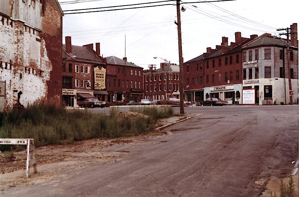
Market Square, 1972 from the alley next to the Fire House.

Market Square, Newburyport, around 1972, before Urban Renewal, from the alley next to the Fire House. Courtesy of Sharon Bauer, via the Newburyport History Buffs.

It always takes my breath away when I see photos of Newburyport before Urban Renewal. This is a photo, courtesy of Sharon Bauer via the Newburyport History Buffs on Facebook, of Market Square before the restoration of downtown. It was a slum. It’s very fancy now, in fact the whole town is very fancy now, but it was a slum. Sharon has the date as 1972, but it may be even earlier than that.

I moved here in 1981, downtown Newburyport had been restored, but the rest of Newburyport surrounding the downtown had not been. I was in the late part of the first wave that “discovered” Newburyport, an historic small city, surrounded by farmland, that seemed to be preserved in amber. We were painters, writers, musicians, teachers who thought we had discovered an unfinished masterpiece.

I bought my first house, a gorgeous Greek Revival on Federal Street, for $74,000 and was upset because the folks who sold it had it for one year and had doubled their money.

By the time I had driven down High Street and had parked on Green Street in front of the real estate agency, I knew this was home. I didn’t even know about Plum Island until after I bought the house (now that was an amazing surprise/plus). The Tannery was still a tannery (David Hall had not yet transformed it) and Maudslay State Park did not exist. The natives looked at those of us who came in early with a whole lot of suspicion (the subject of many, many blog posts over the years on The Newburyport Blog).

One of the things I sensed about Newburyport, I knew absolutely nothing about the city, was its resiliency. And Urban Renewal was not the first time that Newburyport had risen like a phoenix from the ashes. As a young woman that sense of resiliency resinated with me, it still does.

And now, 36 years later, Newburyport is in a “boom” phase. A friend of mine said to me, many, many years ago, that Newburyport was headed up, but it’s history was one of ups and downs, and it would decline again.

As I said, we are fancy now, so fancy I can hardly remember the resilient aura. I loved the city back in 1981 and I’ve loved it as it has blossomed in unimaginable ways. Yes there feels as if part of it is lost (so many blog posts on The Newburyport Blog) but I love where I live 36 years later.

Inn Street, Newburyport MA

Inn Street, Newburyport MA


Local Elections — Not Voting with the Tribe

I would like to offer my congratulations to Mayor Holaday on winning the mayoral election and to all the Newburyport City Councilors, At-Large and Ward Councilors who won, and a big thank you to all who ran but did not win. Thank you all for stepping up, showing up, and caring so much about the community that we all love.

89-91 High Street, the Ridge, Newburyport, MA

89-91 High Street, the Ridge, Newburyport, MA, Courtesy of the Newburyport Archival Center

This local election was really interesting. I supported a candidate for mayor, an honorable man who has served this community with passion and commitment, not just as a Ward Councilor for 8 years, but in other capacities as well, and not our current mayor — it was quite an eye opener — I didn’t vote this year with “the Tribe.”

It appears to me that people were shocked that I and Ward 2 Councilor Jared Eigerman supported Bob Cronin and were vocal about why we were not supporting the current administration. I absolutely understood why people voted for Mayor Holaday, I certainly would never hold it against them, in fact I completely understand why they voted the way that they did, and I am pleased that they cared enough to show up and vote, to get out there and care about our local civics enough to canvas, put up signs, organize. This is Democracy, thank goodness, I thank them for their passion. Apathy is what I dislike the most, not civic engagement, good grief.

There were some lovely people whose response to my “weird choice” was, “We will agree to disagree,” God Bless them and “thank you.” The anger that I saw directed at Councilor Eigerman and at times myself seemed way out of proportion. He and I have agreed that it feels as if we are pariahs (Jared’s phrase) and have semi-officially created “The Pariah Club.” I had thought of calling it The Newburyport Pariah Club, but “The Pariah Club” seems to be the moniker that appears to be sticking. It’s a fairly exclusive club.

What I saw directed at Councilor Eigerman and myself were bizarre rumors and character assassinations. I had people thank me for having the courage to publicly support Bob Cronin. I had people apologize for their fellow citizens. I had people tell me I was nuts and that I should keep my sentiments to myself, they certainly were, and would never let anyone know who they were actually voting for.

I’ve written about this on The Newburyport Blog, over the years my father would shake his head and tell me I needed to learn how to “play the game.” I’m lousy at what my father used to call, “playing the game,” it’s just not in my DNA. Apparently it’s not in Jared Eigerman’s DNA either, which is probably one of the many reasons that I “resonate” with him, and I am proud to be a co-founder with him of “The Pariah Club.”

The Ridge, High Street, Newburyport, MA

The Ridge, High Street, Newburyport, MA, Courtesy of the Newburyport Archival Center

Now as a btw, I would hate to see that anger which has been directed at Jared Eigerman result in a super to the left (if that is possible) challenger for the next City Council election, should Jared choose to run again for Ward 2 City Councilor in 2 years. (The Pariah Club doesn’t have any real world consequences for me the way it possibly could for Jared.)  Jared has been invaluable on the Council. Jared has the expertise, legal expertise, finesse, and political will to make things happens for historic preservation (one of my great Newburyport loves) that I have wished for.

Back in 2012 as the LHD wars were completely disintegrating, then Councilor Ives, now Senator Ives talked to and listened to all sides and came up with a compromise (which as a btw is one of Senator Ives incredible gifts that she has so wonderfully brought to her role as State Senator, I could not be prouder). Jared Eigerman, a then pretty much “unknown” wrote that piece of legislation which Councilor Bob Cronin co-sponsored. It went nowhere. In 2014 Jared Eigerman was elected as Ward 2 City Councilor. As Jared said in his recent Letter to the Editor, Bob Cronin worked with him on “creative legislation to prevent tear downs of historic homes and review major alterations downtown.” In 2014 a version of what Senator Ives had been trying to create became a reality. Since then Councilor Eigerman has had the political will to continue making zoning to protect our historic assets possible. The latest one, which he wrote, and was co-sponsored by City Councilors Ed Cameron and Barry Connell, protects “the Ridge.” I have been wanting this since 1999 when the city fought to save High Street–my own introduction to “civics.”

Just another btw, it used to be that local elections had nothing to do with party politics. It used to be that no one knew what political party local officials belonged to. Not so this election. I was dismayed (and lots of people do not agree with me) to see Massachusetts Attorney General Maura Healey and Congressman Seth Mouton (I’m fans of both) come and stump for one particular mayoral candidate and for the Newburyport Democratic City Committee to run one candidate’s Facebook posts on their Facebook page and to my knowledge not the other candidate. And that’s all I have to say about that (at least for now).

The historic photographs are Courtesy of the Newburyport Archival Center, the link to their online collection can be found here.