Category Archives: Planning and Development

Planning and Development, Newburyport, MA, urban planning, the design, construction and organization of Newburyport’s urban spaces, architecture and activities.

Keeping the Tradition of Community in the South End Alive


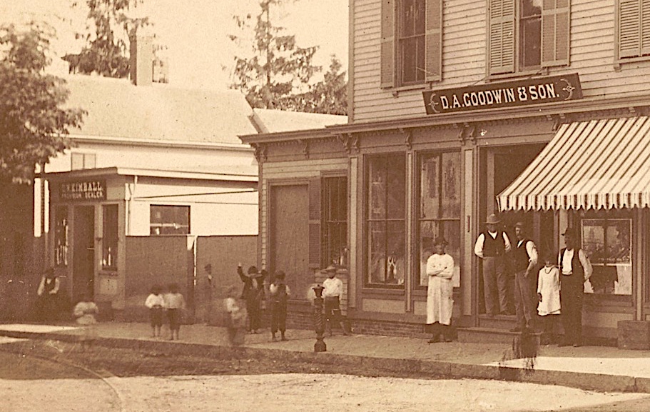
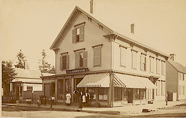
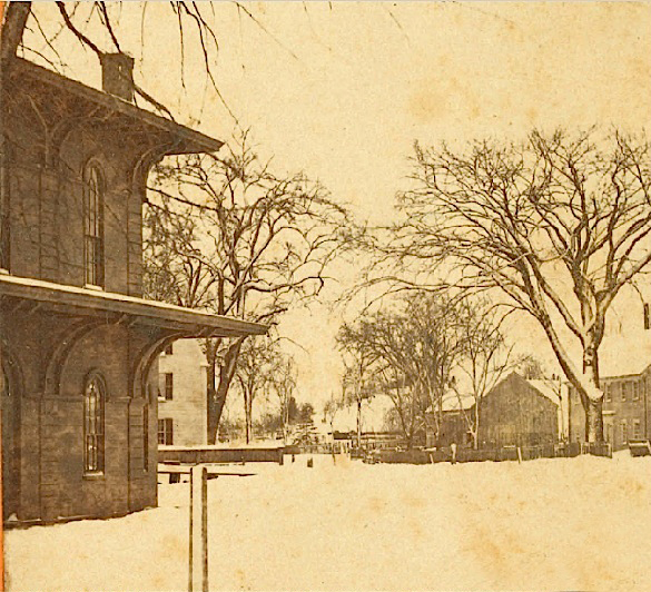
Corner of Purchase and Lime Streets, Newburyport, MA, D.A. Goodwin Groceries

Corner of Purchase and Lime Streets, Newburyport, MA, D.A. Goodwin Groceries, Courtesy of the Museum of Old Newbury

The Corner of Purchase and Lime Streets, Courtesy of the Historical Society of Old Newbury, The Snow Photograph Collection, D. A. Goodwin and Sons Grocery Store – 1864-1917  https://www.digitalcommonwealth.org/search/commonwealth:tq57pr04v

The Brown School was one of the last vestiges of the neighborhood feel of the South End. With the loss of the Brown School the neighborhood lost a place to meet, congregate and make connections that have lasted for some, a lifetime. It is one of the reasons that the neighborhood so appreciates the Newburyport Youth Services. Whatever happens to that site, it would be wonderful to include a place where people can congregate and make neighborhood connections. The Emma Andrews Library and Community Center  (which is located at the corner of Marlboro and Purchase Streets)  is in incredible example of how the neighborhood made a small place into a connected space for people of all ages, run by a dedicated and imaginative group of volunteers. 

The space could be called something like the “George Brown, South End Community Center.” It would not have to be a large space. The Emma Andrews has a handicapped bathroom, a handicapped entrance, a portable refrigerator and coffeemaker and some furniture. That is all the space would need. It could have a small lending library, photos of what the neighborhood once looked like that are available through the Archival Center at the Newburyport Library and the Museum of Old Newbury to keep memories of the neighborhood alive. It could be a place where art is shown, story hours for children, potluck lunch and dinners, book clubs – there are all kinds of ideas. We could also make a space for a few community gardens, something that people have wanted for a long time, where the playground and park will eventually be located, to keep that area vibrant and welcoming, as well as edible. 

As the City wrestles with what to do with this very complex and expensive site ($14 – $20 million estimated in 2014) it would be good to have as part of any eventual plan a place that keeps the fabric of the neighborhood alive and keep the South End tradition of a place where people gather, mingle, find friendship, support and commonality.

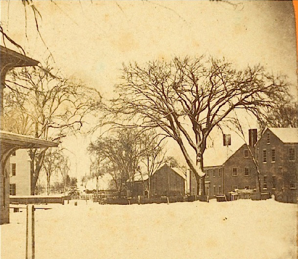
Corner of Purchase and Lime Streets, Newburyport, MA, D.A. Goodwin Groceries

Corner of Purchase and Lime Streets, Newburyport, MA, D.A. Goodwin Groceries, Courtesy of the Museum of Old Newbury

The Corner of Purchase and Lime Streets, Courtesy of the Historical Society of Old Newbury, The Snow Photograph Collection, D. A. Goodwin and Sons Grocery Store – 1864-1917 https://www.digitalcommonwealth.org/search/commonwealth:tq57pr04v


High Street is Wide Around Buck, Johnson and Kent Streets

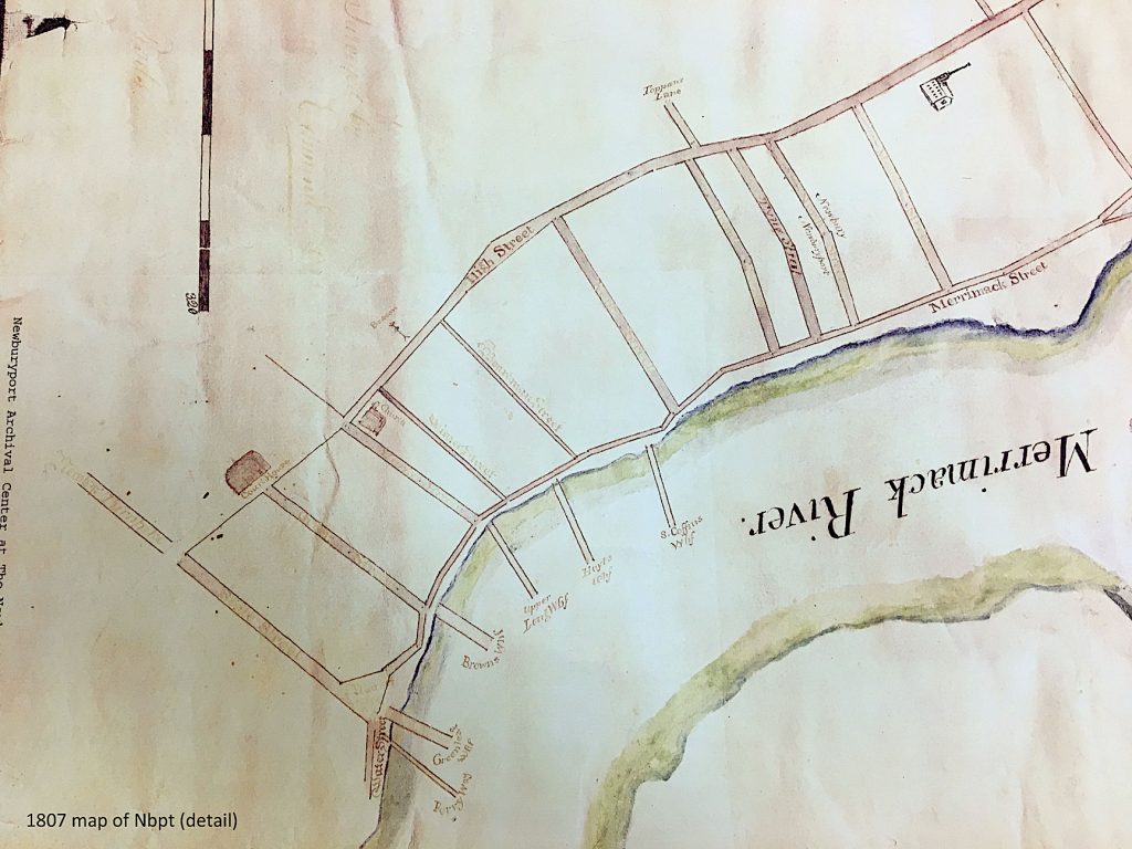
A detail of a 1807 map that shows the wide part of High Street, Courtesy of the Newburyport Archival Center

A detail of a 1807 map that shows the wide part of High Street, Courtesy of the Newburyport Archival Center

A detail of a 1807 map that shows the wide part of High Street, Courtesy of the Newburyport Archival Center

After the fight to save High Street that began in 1998, the High Street Master Plan came into being and the first (and only phase) of the High Street Master Plan was implemented – the bike lanes. There was such a “hubbub” about the bike lanes (they’d  been talked about for 6 years) that they were never actually finished, the High Street Master Plan was vetoed in mid-execution. However, it was finally passed unanimously by the Newburyport City Council, but funding had long since dried up for any further pursuit of the High Street Master Plan.

One of the areas that had long been of concern was the very wide part of the road between Buck, Johnson and Kent Streets. Two years ago the city got a grant to narrow that part of the road and emphasizing biking, walking and being able to safely cross that area of the street, which is really dangerous.*^*  Geordie Vining of the Newburyport Planning Office asked Sharon Spieldenner of the Newburyport Archival Center if there was any reason why that particular part of High Street was so wide. It sounded like a really fun research project and I was “all in.”

This is what we’ve discovered so far.

“Tradition says that it (High Street) was an Indian trail in the beginning, as the low land along the river banks was marshy and sandy, hard to travel upon.” *

“ The country road, now High Street, was then a narrow path or way leading to the ferry at Carr’s island.  Under the direction of the way wardens, or surveyors of highways, it was laid out, four rods wide, for a distance of six miles from the north bank of the Parker river (“High Street, beginning at the Parker River and extending to Three Roads so called.” **^^) (Currier is referring in this paragraph to the year 1649).  Recently the road-bed had been greatly improved by reducing the grade in some places, and laying a firm and solid foundation of broken rock, covered with a finer coating of the same material, nearly the  whole length of the road. When the work is completed, this ancient thoroughfare will be under the care and control of the Board of Highway Commissioners appointed by the state.” **

Boardman Street was laid out as a “way” in 1754 and was called Boardman lane, and then was called Boardman Street in 1764 (when the city separated from Newbury and was incorporated.) ***

Olive Street was laid out as a “way” as early as 1755, in 1794 it was called called Olive lane, and 1817 the town of Newburyport voted to accept Olive Street as a public road. ****

Kent Street has a very interesting story and may be part of the reason why High Street is so wide in that particular area. 

“The brook ceased to flow before Old Newbury was settled. It drained the land between Kent and Olive Streets from the river to High Street, as well as the high land to the summit of the Ridge. It carried a great a great deal of water and many tons of silt to the landing at which it found its way to the Merrimac and tore out the earth a gully that reaches from Russia Street to Merrimac.” *^

It was the creation of Kent Street in 1788 that lead to the building along High Street in the North End, the previous lane/road had been described in the North End Papers as being very dangerous. 
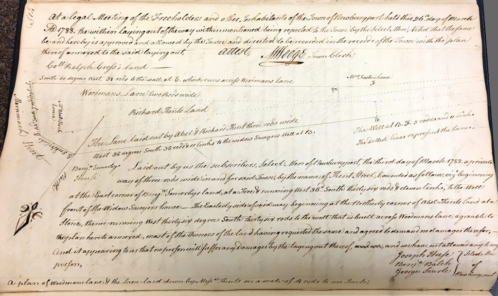
Drawing of Kent Street from the Newburyport Records 1764-1789, year 1788, Courtesy of the Newburyport Archival Center

Drawing of Kent Street from the Newburyport Records 1764-1789, year 1788, Courtesy of the Newburyport Archival Center

Drawing of Kent Street from the Newburyport Records 1764-1789, year 1788,  Courtesy of the Newburyport Archival Center

“The pleasant locations upon the higher land away from the river were not desired or could not be obtained. The opening of Kent and the new streets above started an interest in real estate that lasted until the time of the war of 1812.

“In 1800 Olive lane and Kent Street ran from Merrimac to High. (Ash Lane and Merrill lane, the present Russia Street) No other lanes were open in the whole tract of land from Merrimac to High and from Olive to Kent streets.” **^

203 High Street, was built in 1774, it was owned by John Lowell, and is known as the Lowell-Tracy-Johnson House.

201 High, the Jackson-Dexter House (Lord Timothy Dexter) was built in 1771 and is near what is now Dexter Lane.  

At that time 201 and 203 High were probably on the edge of Newburyport, the rest of High Street being trees, farms and the occasional slaughtering house for farm animals. 203 High Street is just at the edge of where the roadway widens. 

The town records discuss what is then Woodman lane (a version of what is now Kent Street) in 1765,  the comments appear to be pretty critical of the effort by the town of Newbury to create Woodman lane – “it is of no use to the town,” “but as it is now esteemed to be none (no service to the town).” ***^

In 1765 the selectmen recommend a new road, however, Kent Street did not get built until 1787-1788, twenty years later (things took time to get accomplished back then as well apparently.) ***^

Sharon Spieldenner found a map from 1807 that shows the widening around Buck and Kent Street.
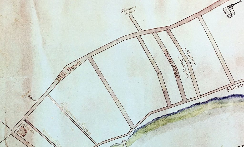
Detail of a 1807 map that shows the wide part of High Street, Courtesy of the Newburyport Archival Center

Detail of a 1807 map that shows the wide part of High Street, Courtesy of the Newburyport Archival Center

Detail of a 1807 map that shows the wide part of High Street, Courtesy of the Newburyport Archival Center

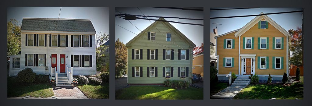
218 High Street, now on the corner of Buck and High was built in 1797 by Captain John Buck. Buck Street was created in 1800, it sits right at the edge of the existing street right where the roadway begins to widen.
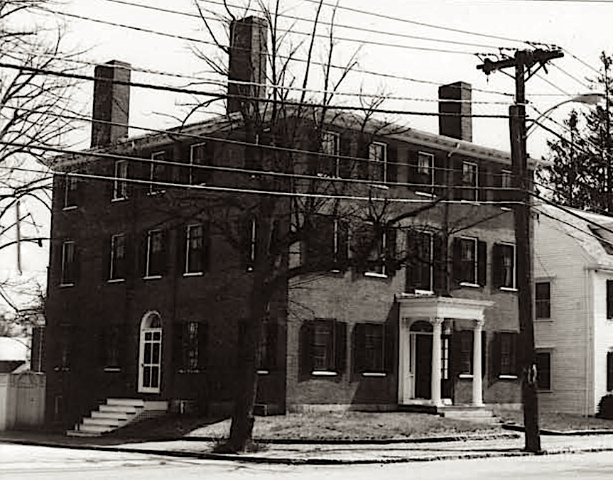
218 High Street, Newburyport MA

218 High Street, Newburyport MA

218 High Street, Newburyport MA

209 High Street, now on the corner of Johnson and High, was built in 1806 also sits on the edge of where the roadway is now. So it appears that we have at least circumstantial evidence that High Street was wide in that area as early as 1797 – 1806, over 2 centuries ago. 
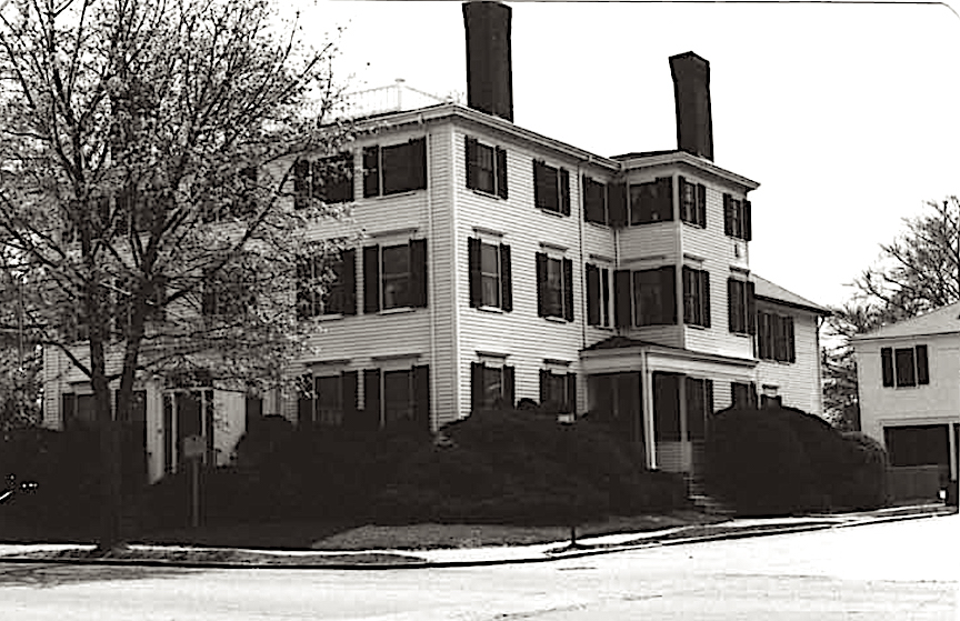
209 High Street, Newburyport MA

209 High Street, Newburyport MA

209 High Street, Newburyport MA

The wide part of High Street and 213 and 223 High Street from today’s city map.
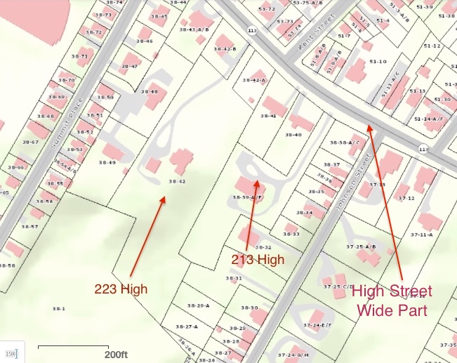
The wide part of High Street and 213 and 223 High Street from today’s city map. 
The wide part of High Street and 213 and 223 High Street from today’s city map.

1924 Assessors Map

1924 Assessors Map

1924 Assessors Map showing the wide part of the road and 213 and 223 High Street
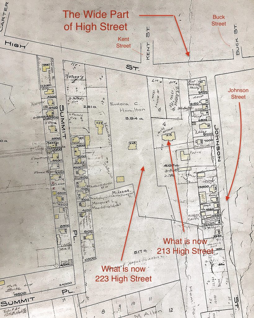
1924 Assessors Map showing the wide part of the road and 213 and 223 High Street

1924 Assessors Map showing the wide part of the road and 213 and 223 High Street

Survey from 1961 of 213 High Street, showing the wide part of the road.
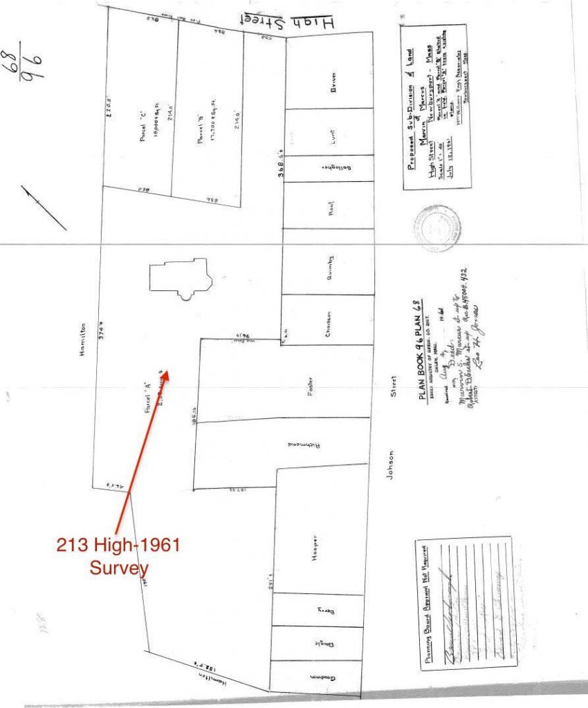
Survey from 1961 of 213 High Street, showing the widen part of the road.

Survey from 1961 of 213 High Street, showing the wide part of the road.

In 1857 there is a survey of what is now 213 and 223 High Street. The land fits perfectly into the land lots (that have now been partially broken up) that exist in today’s city’s map. It shows the angle of the roadway exactly as it is today. So we have absolute proof that High Street was wide in that area for 150 years. (Carrie Keville from the Newburyport Assessor’s Office helped me find the survey.)

Survey from 1857 of what is now 213 and 223 High Street that proves that the roadway was as wide as it is today.
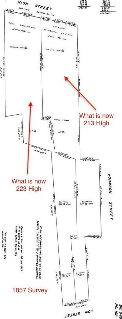
Survey from 1857 of what is now 213 and 223 High Street that proves that the roadway was as wide as it is today. 

Survey from 1857 of what is now 213 and 223 High Street that proves that the roadway was as wide as it is today.

This is a topographical map from the city that I’ve “tweaked” and  shows how the “brook” could have gone down the bottom of 213 High and/or Johnson Street, down what is now Kent Street causing the “gully” as well as possibly down  what is now Buck and Olive Streets. It is a theory as to why that part of the roadway may be extra wide in that particular spot. 

Topographical map showing the area around Bunk, Johnson and Kent Streets
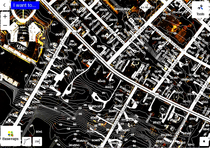
Topographical map showing the area around Buck, Johnson and Kent Streets 

Topographical map showing the area around Buck, Johnson and Kent Streets

It appears that High Street has been wide at Buck, Johnson and Kent Streets for at least 150 years, and it also appears that the street could have been that wide in that particular area for two centuries. 

*An Informal History of the Downtown Streets of Newburyport 1972,  Section on High Street by Josephine P. Driver, Page 131.

(“Josephine P. Driver (1893-1983), one-time curator of the Historical Society of Old Newbury, reminiscences about her childhood memories of her uncle, Elisha P. Dodge, a well-known Newburyport mayor and businessmen, published in Captains, Clams, and Cobblestones, 1977. Her father, Henry B. Little, was a long-time president of the Institution for Savings bank. Mrs. Driver was one of the many citizens and driving forces who advocated for the historic restoration of Newburyport’s downtown during the 1960s.” – Clipper Heritage Trail – Ghee Woodworth)

** John J. Currier, The History of Newbury, Mass.,1635 – 1902, Pages 414 -415

*** John J. Currier, History of Newbury, Mass., 1635 – 1902,  Page 342

**** John J. Currier, History of Newbury, Mass., 1635 – 1902,  Page 342

*^ North End Paper 1618 – 1880, Newburyport, Massachusetts: Development of the North End of the City, by Olive Bl Merrill, Transcribed by Margaret Pecham Motes, Pages 81 and 82. 

**^  North End Paper 1618 – 1880, Newburyport, Massachusetts: Development of the North End of the City, by Olive Bl Merrill, Transcribed by Margaret Pecham Motes, Page 110.

***^ Newburyport Records 1764-1789,  year 1765, Vol 1, page 38 

**^^  John J. Currier, The History of Newbury, Mass.,1635 – 1902, Footnote, Page 90

*^* The Safe Streets to School project is the incentive for the narrowing of this particular area of High Street. As I understand it the goal is that the “overall safety benefits should be considered in balance with historical objectives.”

Editor’s Note – Kent Street:

Woodman’s Lane,  now Kent Street, was probably laid out as early as 1675. In the Newburyport Records 1764-1789 Vol 1, page 38, there is a mention of “an agreement between Colonel Kent, Mr Woodman and the selectman,” the dates that are given for this agreement are 1722/23. It appears that over the years the town was struggling with this part of what is now lower Kent Street, and that the opinion in 1765 is that the road that was created around 1723 was “of no use to the town.“  *^^* 

The two drawings below are what lower Kent Street – then a combination of Woodman’s Lane and Merrill Lane, which was trying to negotiate around the gully, once looked like.  

Here are two images from the Newburyport Records 1764-1789, Vol 1, page 222, courtesy of the Newburyport Archival Center
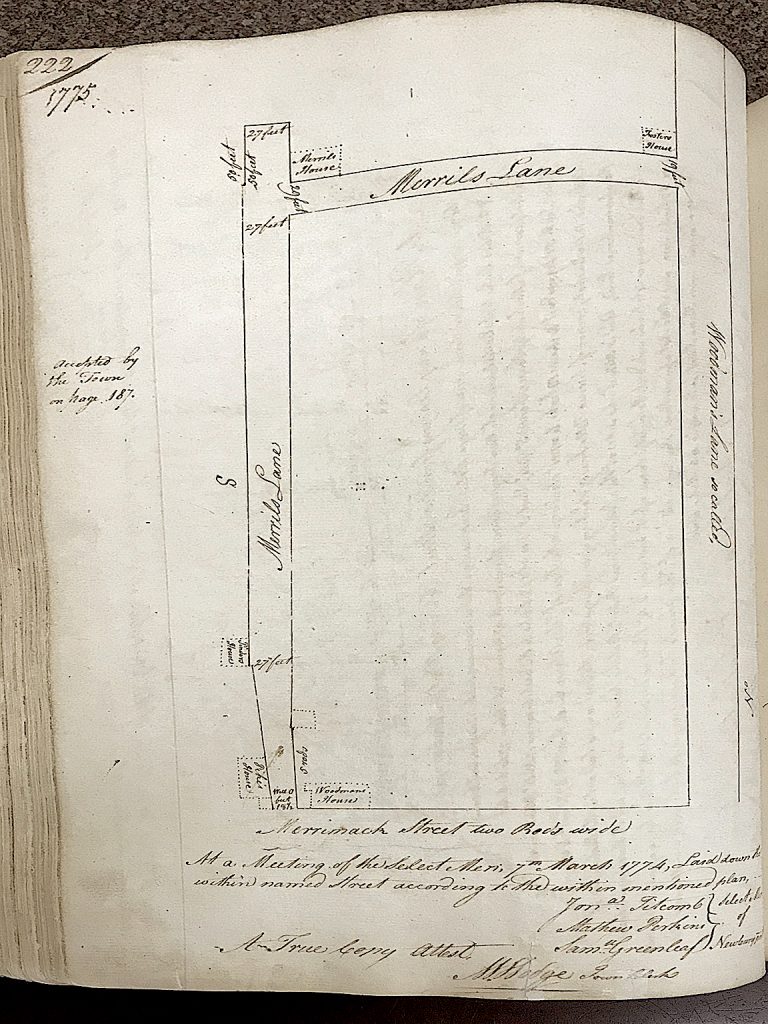
Map of Wood’s Lane and Merrill Lane 1775 from the Newburyport Records 1764-1789, Vol 1, page 222, courtesy of the Newburyport Archival Center

Map of Wood's Lane and Merrill Lane 1775 from the Newburyport Records 1764-1789,  year 1775, Vol 1

Map of Wood’s Lane and Merrill Lane 1775 from the Newburyport Records 1764-1789,  year 1775, Vol 1

Detail of the map of Wood’s Lane and Merrill Lane,  from the Newburyport Records 1764-1789,  year 1775, Vol 1, page 222, courtesy of the Newburyport Archival Center
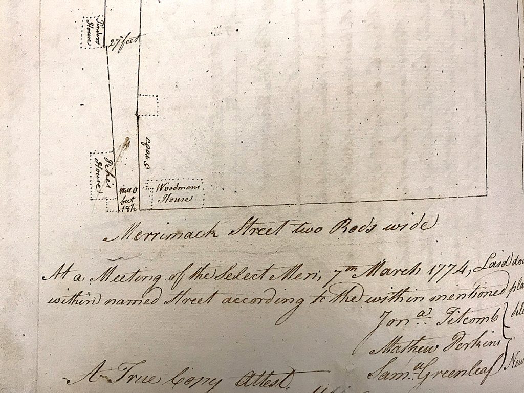
Detail of the map of Wood's Lane and Merrill Lane 1775 from the Newburyport Records 1764-1789,  year 1775, Vol 1.

Detail of the map of Wood’s Lane and Merrill Lane 1775 from the Newburyport Records 1764-1789,  year 1775, Vol 1.

And from the survey of Kent Street in 1788 it looks like lower Kent Street was completely re-configured, moving the entire lower part of the roadway north of the existing street. 

Detail of the survey of Kent Street in 1788, it looks like lower Kent Street was completely re-configured, moving the entire lower part of the roadway north of the existing street. *^*^ 
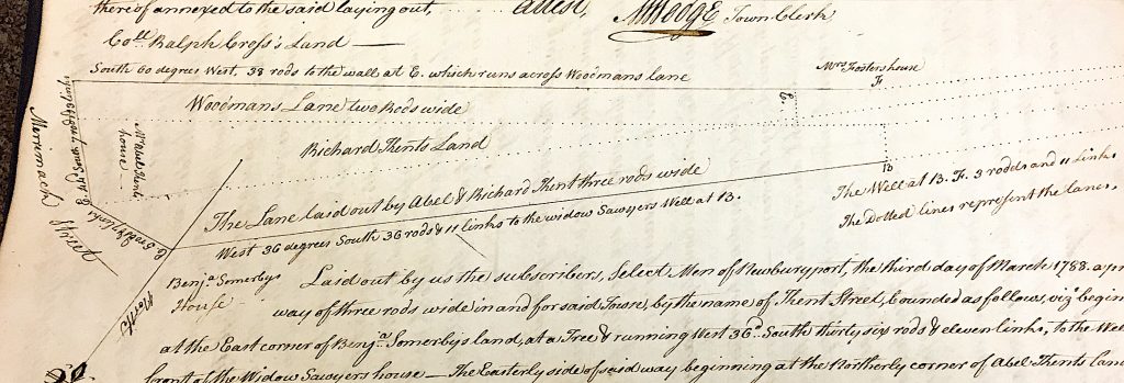
Detail of the survey of Kent Street in 1788, it looks like lower Kent Street was completely re-configured, moving the entire lower part of the roadway north of the existing street. 

Detail of the survey of Kent Street in 1788, it looks like lower Kent Street was completely re-configured, moving the entire lower part of the roadway north of the existing street.

*^^* John J. Currier, History of Newbury, Mass., 1635 – 1902,  Page 344

*^*^ Detail of the drawing of Kent Street from the Newburyport Records 1764-1789, year 1788, courtesy of the Newburyport Archival Center.

Editor’s Note:

This is a detail of really early map courtesy of Sharon Spieldenner of the Newburyport Archival Center. A guess on the date might be around 1720.
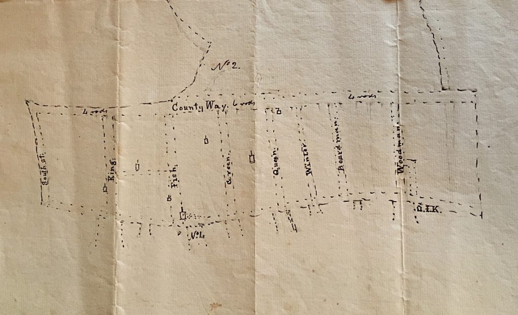
A detail of a really early map courtesy of Sharon Spieldenner of the Newburyport Archival Center. A guess on the date might be around 1720.

A detail of a really early map courtesy of Sharon Spieldenner of the Newburyport Archival Center. A guess on the date might be around 1720.

A detail of a really early map courtesy of Sharon Spieldenner of the Newburyport Archival Center. A guess on the date might be around 1720.

This is a theory/guess by Rick Taintor as to why the High Street is so wide between Kent and Buck Street. 

“The road was laid out at a specific width, but probably wasn’t engineered with curving sidelines.  I’ve drawn two pairs of straight lines representing a theoretical original layout, meeting at an angle just west of Johnson Street.

However, the early users probably cut corners, especially when pulling wagons rather than just riding horses, and particularly where no development had yet occurred. Over time, the actual roadbed could have shifted to a smooth curve between Kent and Johnson, so the traveled way might have moved out of the original sidelines.  At some later date, the angle of the sideline on the north side of the road could have been adjusted to ensure that the right of way encompassed the traveled way.”

A drawing of a theory of why the High Street is so wide between Kent and Buck Street.
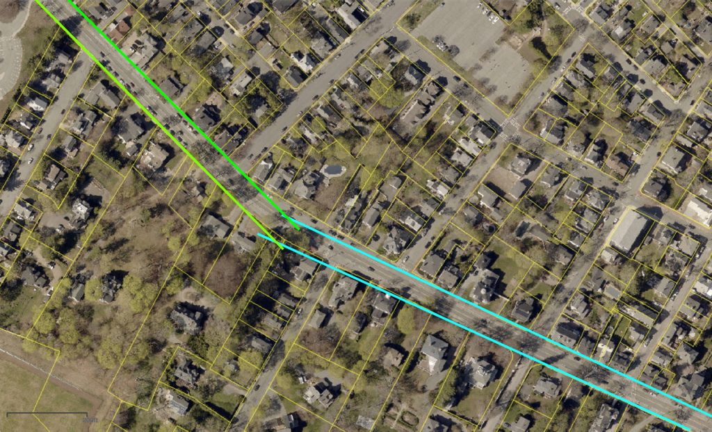
A drawing of a theory of why the High Street is so wide between Kent and Buck Street.

A drawing of a theory of why the High Street is so wide between Kent and Buck Street.

From John J. Currier “History of Newburyport, Mass: 1764 – 1905” Vol I, page 22, the map was drawn in 1795 but represented Newburyport in 1764. High Street bends at Woodman’s lane. Reproduced from the Massachusetts Archives (Town Plans, vol II., Part I.)
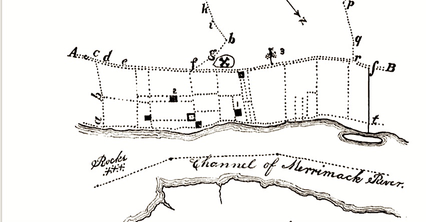
From John J. Currier “History of Newburyport” Vol I page 22, the map was drawn in 1795 but represented Newburyport in 1764. High Street bends at Woodman's lane.

From John J. Currier “History of Newburyport” Vol I page 22, the map was drawn in 1795 but represented Newburyport in 1764. High Street bends at Woodman’s lane.
10 Residential Units at the Brown School Would Make the Neighborhood Feel a Whole Lot Better

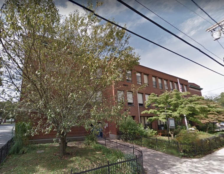
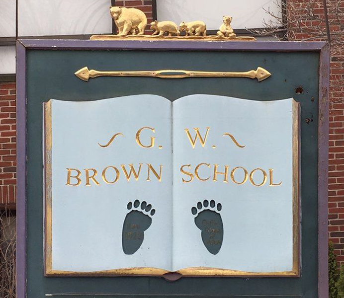
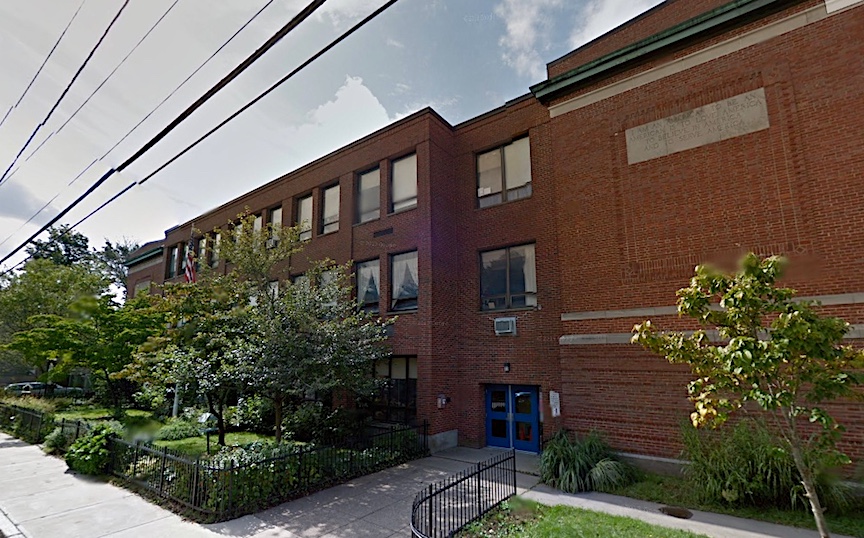
The Brown School

The Brown School

The Brown School, Newburyport

I’ve been scratching my head as to where in the world the push for 27-29 affordable senior housing units came from for the Brown School, which is a complete about face from the direction that the City had been going for as re-use for that property.

It has come from good folks in Newburyport.

And from someone who lives in the Brown School neighborhood 27-29 units of any size is nuts.  This is one of the most densely populated areas of the city with narrow 18th century streets. On street parking is already a nightmare, we already have what I call “neighborhood road rage” when it comes to parking and traffic.

The temperature in the neighborhood would go down a whole lot if the proposal was for 10 residential units. That’s realistically 20 cars. And if the neighborhood got to have the Newburyport Youth Services (NYS) stay, that would be a big extra bonus.

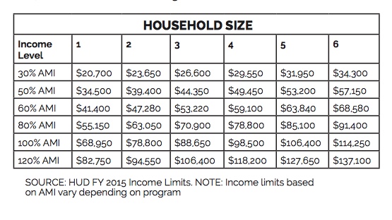
There are a variety of different affordable categories which are referred to as Affordable Medium Income (AMI). Here is table from a 2015 household study from Boston, Newburyport is considered part of the Boston Hud Federal  Management Regulation (FMR) area.

2015 Affordable Medium Income (AMI)

2015 Affordable Medium Income (AMI)

2015 Affordable Medium Income (AMI)

As you can see there are different percentages of the AMI, 30%, 50%, 60%, 80%, 100% and 120%.

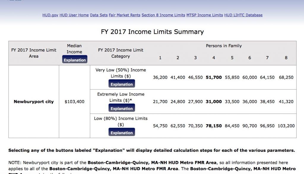
According to HUD the Medium Income for Newburyport in 2017 is $103,000. This table show 50%, “Extremely Low” and 80%.

Newburyport 2017 AMI

Newburyport 2017 AMI

Newburyport 2017 AMI

If the City put out a Request For Proposal (RFP) for 10 units, they could be half market rate and half affordable, or all affordable at let’s say 5 different levels of AMI (that’s the % of income) if funding could be found for different AMI levels in the same building. I think under scenarios along these lines that most of the neighborhood would be breath a sigh of relief.

Newburyport Youth Services (NYS)

Newburyport Youth Services (NYS)

Newburyport Youth Services (NYS)

And my understanding is that there is no place for NYS to go even if there was funding. My impression was that NYS did not want to be in the building or the neighborhood, but that’s not the case at all — they love where they are. I thought NYS had somewhere they could go, but apparently that is not the case.

Councilor Jared Eigerman’s Ordinance now in front of the City Council is a wonderful starting place.  I hope we can get to a place where NYS, affordable housing folks and the neighborhood are not pitted against each other, but where we can all come together and find a solution that has something for everyone and not everyone gets everything they want – that’s what I call good negotiating.

Editor’s Note:

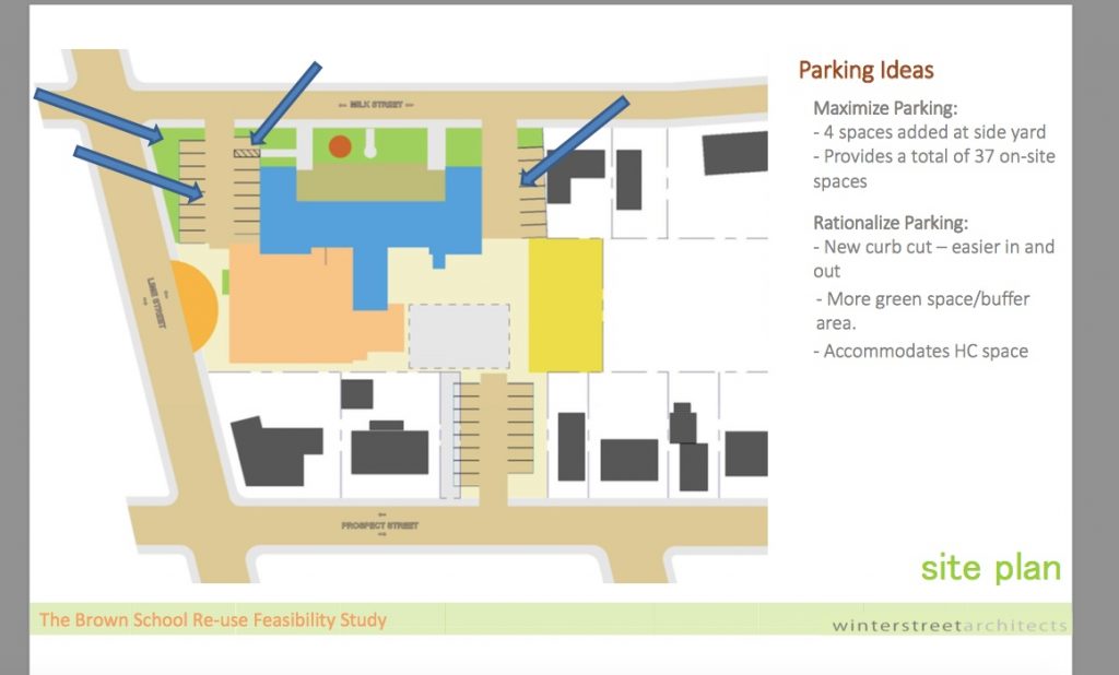
This is from the 2014 Brown School Feasibility Study. There are 37 available parking spaces. If there were 10 units, that would realistically be 20 cars and 17 left over parking spaces. The basketball court at the Brown School Park and possibly parts of the Brown School Park itself could be used for snow emergency parking for the neighborhood along with those extra 17 spaces.

Brown School Parking from the 2014 Feasibility Study

Brown School Parking from the 2014 Feasibility Study

Meetings on What Will Happen to The Brown School

The Brown School

The Brown School

The City is now actively concentrating on what to do with the Brown School. Although the template for what to do with the Brown School has been the 2014 Brown School Feasibility Study, the City of Newburyport is now taking a different approach. The school is in terrible shape, and would cost around $14 million to rehab/fix/develop it. The school and the land itself has been appraised at $5.5 million. Understandably the City would like a developer to develop that property.

I was very upset at the last Brown School meeting that affordable housing advocates from all over the city were “rounded up” on Facebook and by word of mouth. The push was for all affordable housing. The neighbors felt intimidated about speaking up about their concerns about parking, traffic and density, worried that they would be labeled as being discriminating against poor people and the elderly, and the fact that this was a completely different direction than the one they had been lead to believe that the City was going in for the last 3-4 years, i.e. The Brown School Feasibility Study.

City Councilor Jared Eigerman  introduced an Ordinance for Monday’s City Council Meeting. I am very grateful to Councilor Eigerman that he has done this. I hope that it is the beginning of a thoughtful dialogue on the new directions that the city is taking for this project.

“This is my (Councilor Eigerman’s) attempt to reconcile all of the interest that I’ve heard over the past five years and balance it out,” Eigerman said, noting that the ordinance will likely be sent to one of the City Council’s committees and ultimately require a positive vote from eight of the 11 councilors.

“Now, with my colleagues, we’re going to hammer it out,” From the Daily News, February 9, 2018.

The Ordinance proposes 40%-60% affordable housing, which I think is a good mix.

The Ordinance proposes 1-1.5 cars per unit. I think that is really unrealistic parking for the neighborhood. I think at least 2 cars per unit is realistic.

The Ordinance calls for 24 units, which I think is way too many units for this property. (Councilor Eigerman has assured me that all of this in his mind would be open for discussion. I trust him a lot.)

The Ordinance would enable the Newburyport Youth Services (NYS) department to serve City residents, “consistent with its mission,” and to Identify public monies for the “NYS to continue to serve Newburyport residents after it relocates from the Brown School Site.”

The Ordinance would protect the 2013 Brown School Park, roughly 11,000 square feet.

The Ordinance calls for, “Mitigating negative impacts upon the neighborhood from changes in use of the Brown School Site, with particular concern for quality of design, traffic, and parking.”

The Ordinance calls for, “Providing for a diverse, balanced, and inclusive community, with housing for people of all income levels as a matter of basic fairness and social responsibility, and to promote economic stability within the community.”

The Ordinance calls for “Protecting the historic exterior features of the schoolhouse building.”

The Ordinance can be found here in the City Council packet https://www.cityofnewburyport.com/sites/newburyportma/files/agendas/city_council_packet_02_12_18_reduced.pdf

I think that it is really important for people to contact all 11 of our Newburyport City Councilors, not just Councilor Eigerman (Ward 2) and Councilor Sharif Zeid (Ward 1). The City Councilor’s contact information can be found here: https://www.cityofnewburyport.com/city-council .  I would also Cc Mayor Holaday and our City Planner Andy Port.

The Ordinance was sent to the City Council Planning and Development Committee at Monday night’s City Council meeting. I was very relieved by this. They will be holding sub-committee meeting on the Brown School. If you care about this project please attend those meetings, this is where a discussion of the fate of the Brown School will take place. The first meeting will be scheduled the week of February 26th.

The Brown School

The Brown School

The Re-Use of the Brown School

The Community Coming Together Working on the Brown School Park, September 2013.

The Community Working on the Brown School Park, September 2013

The Community Working on the Brown School Park, September 2013

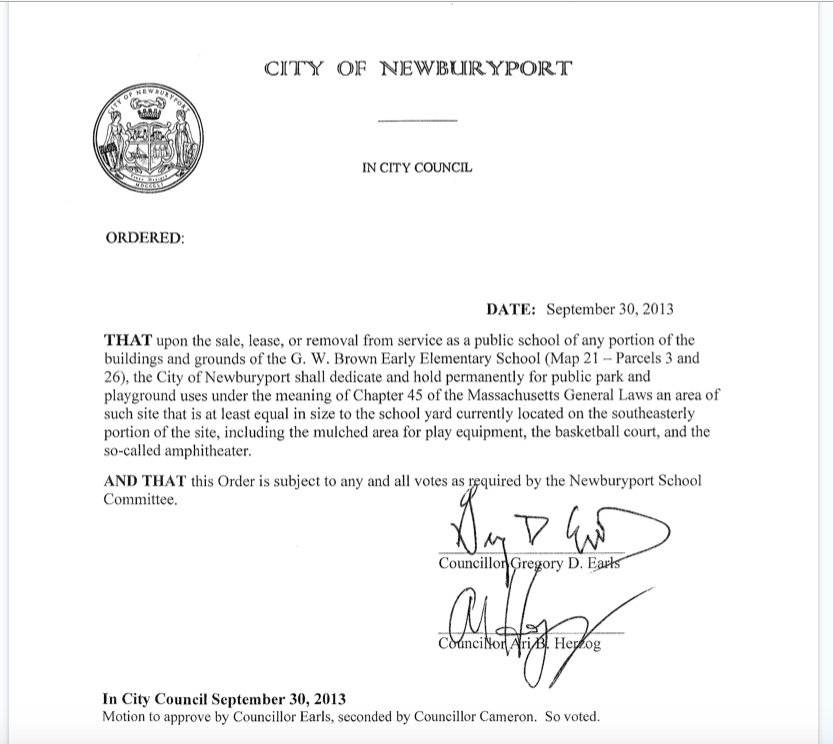
In 2013 the city rallied to protect the Brown School Park after the Brown School was decommissioned. The neighborhood desperately wanted to at least keep some of the community feeling that the Brown School created. Citizens worked really hard on a petition drive to protect the Brown School Park. And on September 30, 2013 the Newburyport City Council passed an Order that protects about 10,000 square feet of the Brown School for a park in perpetuity, it was then approved by the Newburyport School Committee.

The 2013 Order to protect the Brown School Park

The 2013 Order to protect the Brown School Park

The 2013 Order to protect the Brown School Park

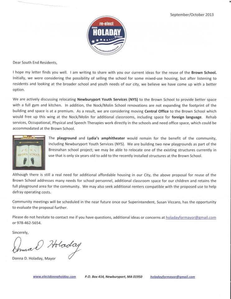
In the fall of 2013 Mayor Donna Holaday reassured the South End that the Brown School would not be closed, “we were considering the possibility of selling the school for some mixed-use housing, but after listening to residents and looking at the broader school and youth needs of our city, we believe we have come up with and better option.” Mayor Holaday’s words, not mine.
Mayor Holaday’s 2013 Letter

Mayor Holaday’s 2013 Letter Not to Sell the Brown School

Mayor Holaday’s 2013 Letter Not to Sell the Brown School

In 2014 the City spent $40,000 on the Brown School Feasibility Study *, which is excellent. However it does point out that in 2014 the Brown School and the land is worth over $5 million * (it has recently been appraised at $5.8 million) and the cost in 2014 to develop/fix the Brown School is close to $14 million — that’s a total of $19-20 million dollars *, that’s a lot of money.

This year, just recently the mayor did a complete about face. In the Thursday January 25th meeting the mayor said that the Newburyport Youth Services (NYS) would be removed from the building *** (the Brown School neighborhood loves having the NYS there **) and the building would be used for all affordable housing. In my opinion that is nuts given the density of the neighborhood and the parking and traffic issues.
To my dismay, what now seems to be happening is that the neighborhood and the Brown School Park are now pitted against the affordable housing folks which is awful. We want to work together to meet all the needs, not have the community divided against each other.

These are Links to:

The Brown School Re-Use Updates

* The Brown School Re-Use Feasibility Study 10/30/14

**The Public Comments (which are very favorable) to the draft of the feasibility study and options as of 11/18/14

*** From an email from the Director of Youth and Recreation Services, Newburyport Youth Services (NYS), February 1, 2018

“Dear NYS Friends and Families,

It was announced last Thursday at a public meeting that NYS will no longer be part of the re-use proposals for the Brown School. The plan, as of now, is that the City hopes to move forward with a Request for Proposals (RFP) to developers focused on creating affordable housing. At the meeting, the Mayor did state the City may retain the gymnasium (to be overseen by NYS) and then find, buy, lease or build a new space for NYS.”

Meetings that Push Agendas Rather than have Thoughtful Critiques — Recently the Reuse of the Brown School

Push an agenda

Last year I worked on a national level to save the Affordable Care Act (ACA) from Republican repeal efforts. It was fascinating and not unlike local politics. And my experience in local politics helped me emotionally navigate this new political terrain.

I joined up online with a bunch of folks at Vox.com, the group is called “A Community for Obamacare Enrollees by Vox.com.”  And one of the things we did was organize people to go to Capital Hill for committee meetings on health care. I watched a ton of meetings on Capital Hill, and my frustration was immense. The meetings by the Republicans in February 2017 were completely choreographed to produce a result that promoted their agenda, it wasn’t about an honest discussion at all. Later in the year, there was actually a great series of health care committee meetings, and they were completely different. Everyone on both sides of the aisle listened to a variety of witnesses with very different viewpoints. They were rational, constructive and very informative and a really good example of governing. I was really impressed.

In Newburyport we are not immune from meetings that are what I call “push agenda meetings,” that have a specific end goal in mind and are not an open discussion of different possibilities and options. The first one I went to was a sub-committee on plastic bags, it was a nightmare, the process was so bad that I blogged about it.

I remember writing that the meeting seemed to me to be more about a homily to a plastic bag ban, than a how could we problem solve this together as a community. It was stacked with anti-plastic bag folks from Newburyport as well as folks from as far away as Boston.  There was a woman at that meeting, not from Newburyport, who had the gall to say that plastic bag lobbyists lived among our wards and were giving bribes to our city councilors – which was absolutely nuts. Did the folks who were running the meeting, who were City Councilors, bat an eye. No they did not. And any suggestion of having a nuanced approach was shouted down by people in the meeting. The meeting was completely out of control. I vowed I would never, ever go to a Newburyport civic meeting again. But I did.

I went to the public meeting on the 40R, it was a joint meeting with the City Council and the Planning Board. I had a lot of questions about the 40R and so did a lot of folks. My impression was that the meeting was stacked in favor of the 40R (and later a City Councilor quite proudly told me that yes indeed, the meeting was stacked in favor of the 40R, they made sure that it was). Lots of folks spoke in favor of the 40R and were warmly received. Anyone with questions, were dismissed. I walked out. Friends of mine who went, who had lots of very smart reservations about the 40R, asked me what was going on, they could not believe it. Unfortunately I said they were right. Any sort of practical or thoughtful critique of the 40R proposal was not part of the “agenda.”

The recent “neighborhood” meeting on the reuse of the Brown School was a stacked meeting for affordable housing. Anyone who knows me at all, knows that the fact that Newburyport has become so unaffordable really upsets me, and I am all for affordable housing with a big and small “A.” The meeting was not for the neighborhood to constructively discuss what to do with the Brown School and discuss what to do about affordable housing in Newburyport and at the Brown School. The meeting was to push an agenda for the Brown School by the current administration. I’ve been told that there were folks from outside the neighborhood (all well meaning) who showed up to speak in favor of all affordable housing for the Brown School, which is very different from what the city proposed in 2014And I’ve also been told that the neighbors who had reservations about the idea felt intimidated about speaking up. This surprises me not at all.

So, for the neighbors of the Brown School who would like a say in what happens (and it’s very complicated, I’m not saying it’s not), please email the mayor and all the Newburyport City Councilors with your thoughts, ideas and concerns. They will not be able to make an informed decision if they do not hear from you. The City Councilor’s contact information is here.

Push

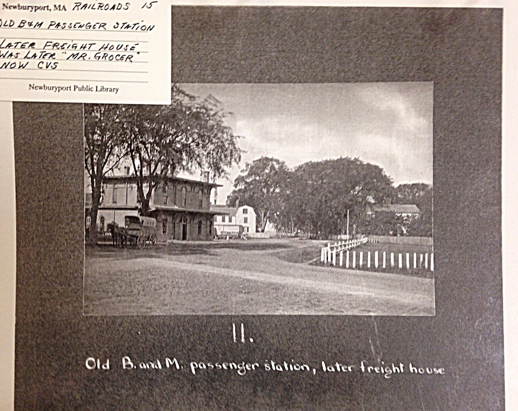
Newburyport, There Once was a Railroad Station on Pond Street where CVS is Now

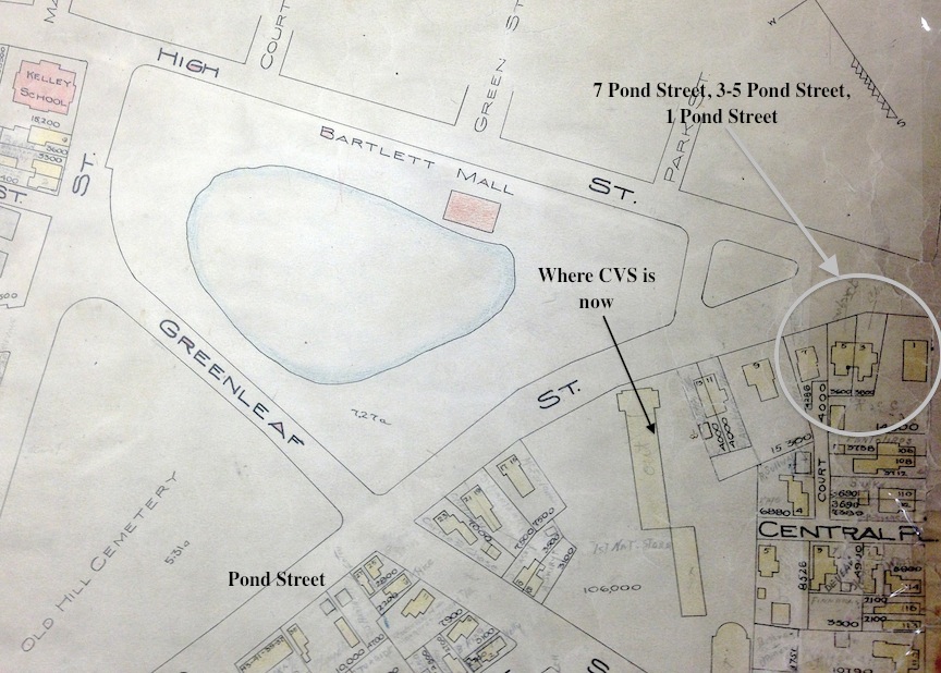
Back in September when I did a story on 7 Pond Street I discovered all sorts of things about Pond Street and the Bartlet Mall that I never knew before. And one of those things is that there was once a railroad station where CVS is now located.

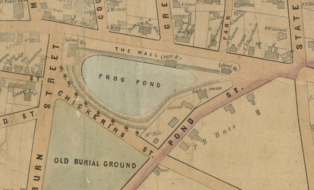
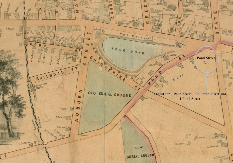
The 1851 Map of Frog Pond

1851 Map, Frog Pond, Newburyport, MA

1851 Map, Frog Pond, Newburyport, MA

In the 1851 Map of Frog Pond there are a bunch of houses between Frog Pond and Pond Street.

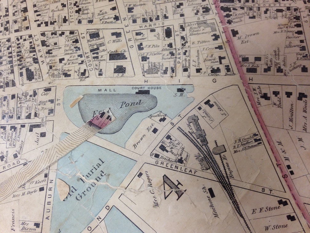
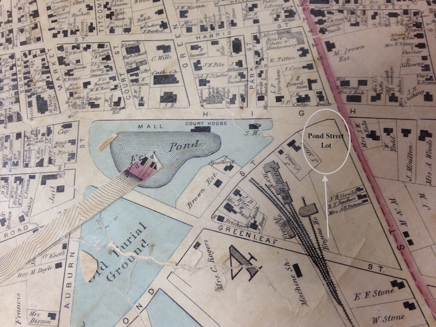
The 1872 map showing the Railroad depot.

1872 Map showing Frog Pond and the Rail Road

1872 Map showing Frog Pond and the Rail Road

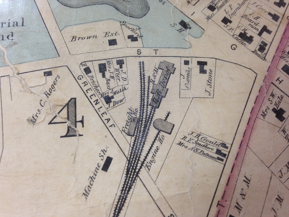
In the 1872 map most of those houses still exist, but low and behold there is a train depot across the street where CVS is now located.

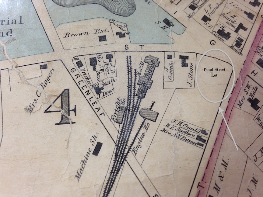
Detail of the 1872 map

1872 Map, detail, Rail Road, Pond and Greenleaf Street

1872 Map, detail, Rail Road, Pond and Greenleaf Street

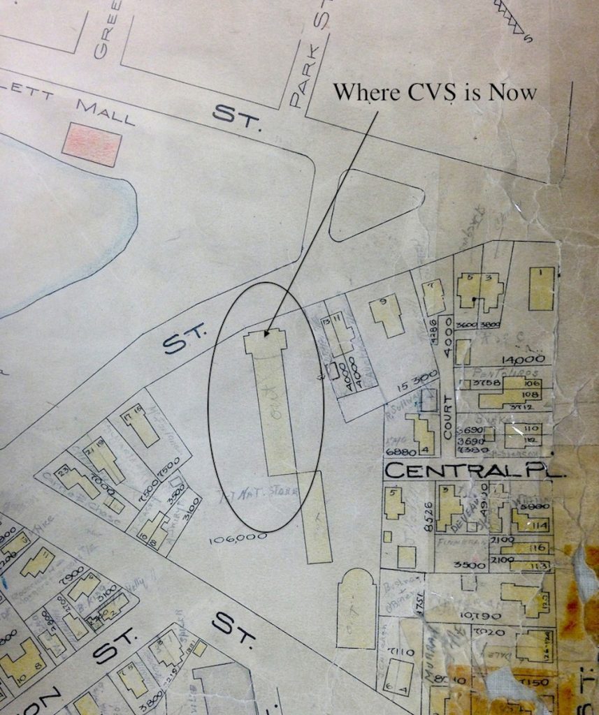
The 1924 map of Pond Street

1924 Map of Pond Street

1924 Map of Pond Street

And in the 1924 map the houses between Frog Pond and Pond Street are now gone, but the building where CVS is now is still there.

A map of the rail road routes into and out of Newburyport, from Scott’s Railroad Archaeology Page

A map of the rail road routes into and out of Newburyport, from Scott's Railroad Archaeology Page

A map of the rail road routes into and out of Newburyport, from Scott’s Railroad Archaeology Page

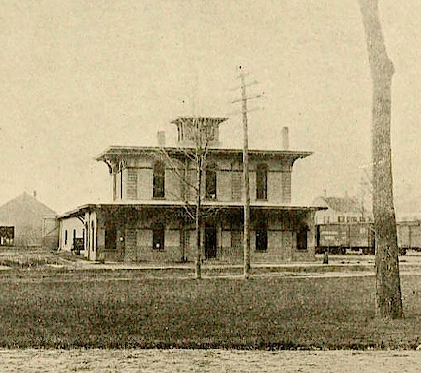
Fortunately Joe Callahan wrote an article in the Newburyport Daily News in 2009 with lots of information about the railroad station. Joe wrote that around 1853 the Boston and Maine Railroad took over the operation of the Newburyport Railroad Company and both passenger and freight service existed. The passenger depot building faced Pond Street and the Bartlet Mall.  Around 1884 passenger service stopped on Pond Street and the depot was used only for freight.

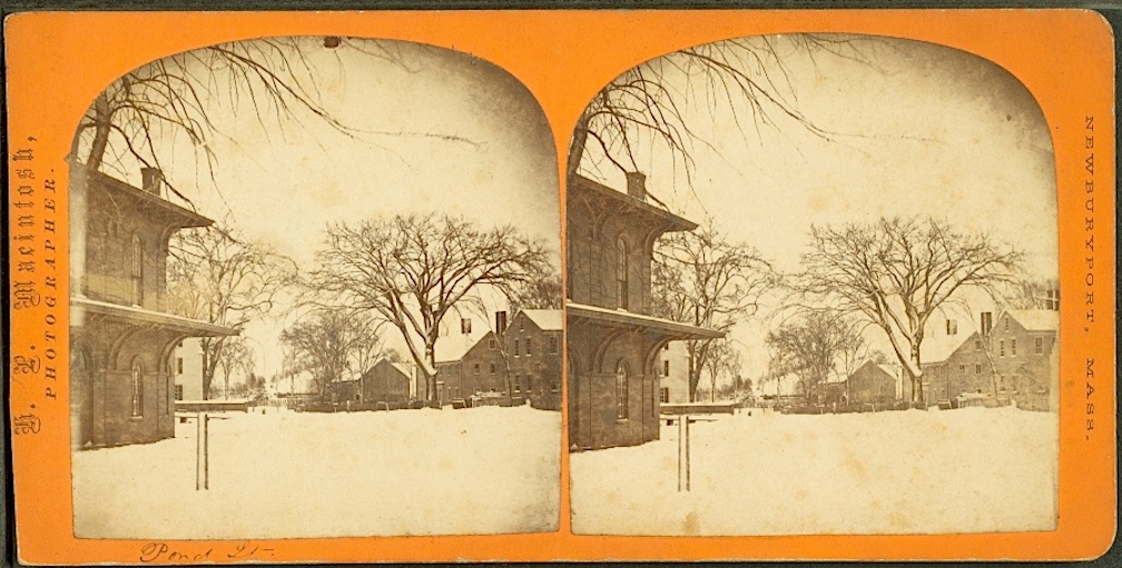
This is a photograph of the Pond Street Depot from the New York Public Library.

Pond Street Depot from the New York Public Library

Pond Street Depot from the New York Public Library

Pond Street from the New York Public Library, The Miriam and Ira D. Wallach Division of Art, Prints and Photographs: Photography Collection, The New York Public Library. “Pond St.” The New York Public Library Digital Collections.

Detail of the passenger station depot with houses across the street courtesy of the New York Public Library

Detail of the passenger station depot with houses across the street, New York Public Library

Detail of the passenger station depot with houses across the street, New York Public Library

Second detail with the houses across the street (that are on the map) from the New York Public Library

Detail of the passenger station depot with houses across the street, New York Public Library

Detail of the passenger station depot with houses across the street, New York Public Library

The New York Public Library also has this photograph of the Pond Street houses.

Pond Street houses, courtesy of the New York Public Library

Pond Street houses, courtesy of the New York Public Library

Pond Street houses, courtesy of the New York Public Library

And yes indeed they match exactly the photograph that we have in the Newburyport Public Library of the houses that once belonged to Stephen Hooper (see earlier post).

Pond Street houses courtesy of the Newburyport Archival Center

Pond Street houses courtesy of the Newburyport Archival Center

Pond Street houses courtesy of the Newburyport Archival Center

All of which is pretty cool.

And the Newburyport Public Library also has a photograph of the B&M Passenger Station in the Archival Center.

Passenger station courtesy of the Newburyport Archival Center

Passenger station courtesy of the Newburyport Archival Center.

Passenger station courtesy of the Newburyport Archival Center.

A second photograph of the train station across from Frog Pond courtesy of the Newburyport Archival Center.

Passenger station, Pond Street, courtesy of the Newburyport Archival Center

Passenger station, Pond Street, courtesy of the Newburyport Archival Center

By 1921 the train station looks like it had fallen on harder times. This photograph is from a book published in 1921, “The Boston and Maine Railroad; a history of the main road, with its tributary lines,” by Francis Boardman Crowninshield Bradlee.

The Newburyport train station in 1921

The Newburyport train station in 1921

The Newburyport train station in 1921

Joe Callahan writes that, “The original passenger depot building that faced on Pond Street was purchased in 1928 by “Bossy” Gillis and moved to Dalton Street. It was demolished several years later.”

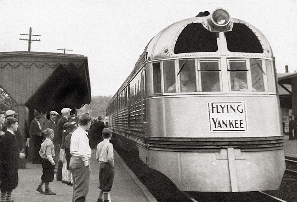
On February 21, 1935,  according to Joe, “The new B&M “Flying Yankee” streamliner arrived at the Pond Street yard and opened for public inspection. The Daily News reported 6,000 people boarded and viewed its lavish interior.”

The Flying Yankee was a very big deal.

Photograph of the Flying Yankee

Photograph of the Flying Yankee

Photograph of the Flying Yankee

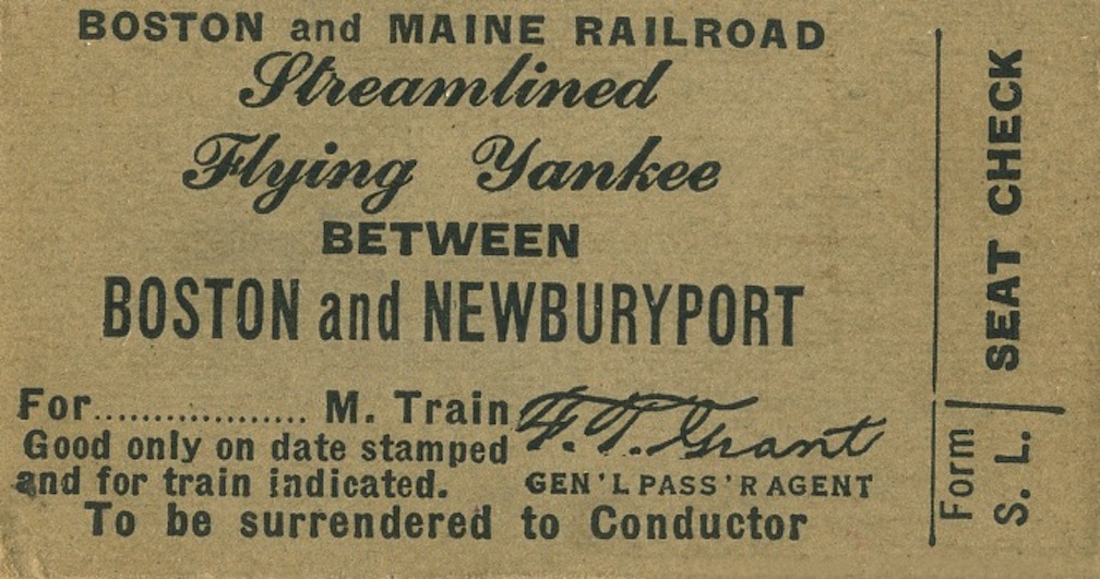
A ticket for the Flying Yankee between Boston and Newburyport

A ticket for the Flying Yankee between Boston and Newburyport

A ticket for the Flying Yankee between Boston and Newburyport

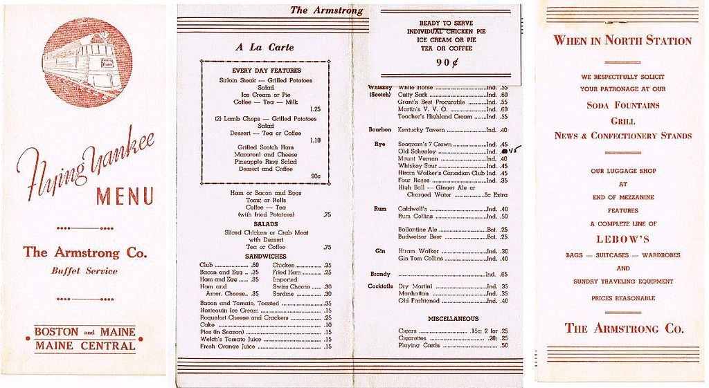
A menu for the Flying Yankee

A menu for the Flying Yankee

A menu for the Flying Yankee

There was no kitchen or dining car for food preparation on the train, passengers ate at their seats with trays similar to airline service. The food for the train was provided by the Armstrong Company.

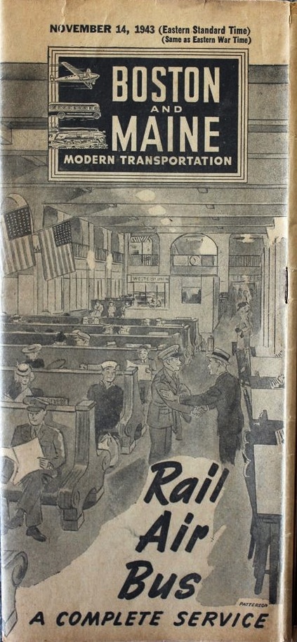
The Boston and Maine Timetable  1943

The Boston and Maine Timetable 1943

The Boston and Maine Timetable 1943

According to Joe, “There was an old wooden roundhouse at the Pond Street yard, and upon the elimination of the passenger service, it was moved to face Greenleaf Street. In March 1908, Glen Mills Cereal Company of Rowley leased the structure and operated for many years making flour. The mill, under different owners, ceased operations in the early 1940s. Both Hytron and C. Leary Bottling Company leased the building for storage for many years following the mill operations.”

Joe writes that, “Back in the 1940s, there were always 10 or 12 freight cars at the depot. New cars arrived almost daily and were immediately unloaded.” And  “With the decline of the railroads in the 1950s, the Pond Street site was closed and sold to the First National Supermarket chain. The last freight train out of Pond Street was in late 1954.

The freight house and the mill were demolished in the summer of 1955 and the tracks removed then as well. The First National opened in October 1956, expanded with an addition in April 1968 and closed in July 1980. A couple other food stores operated for short periods of time, but were unsuccessful before giving way to the busy CVS.”

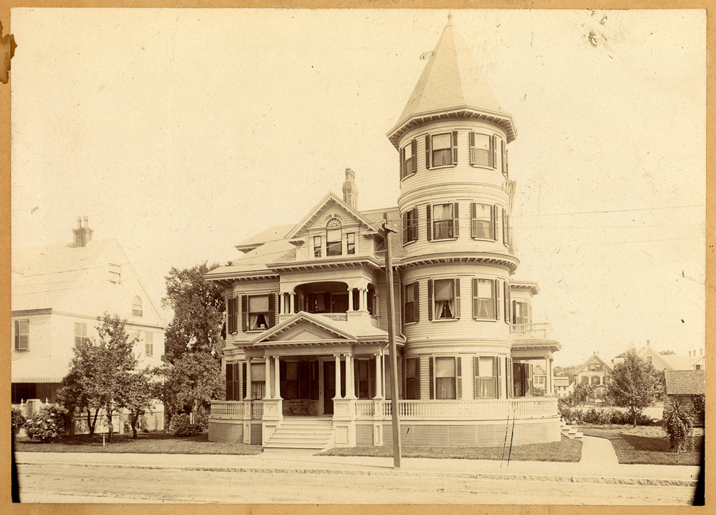
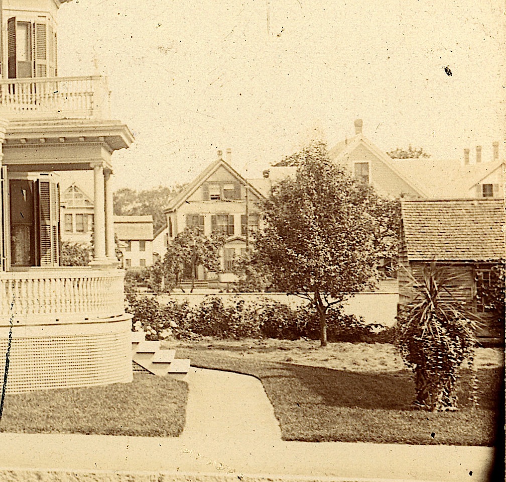
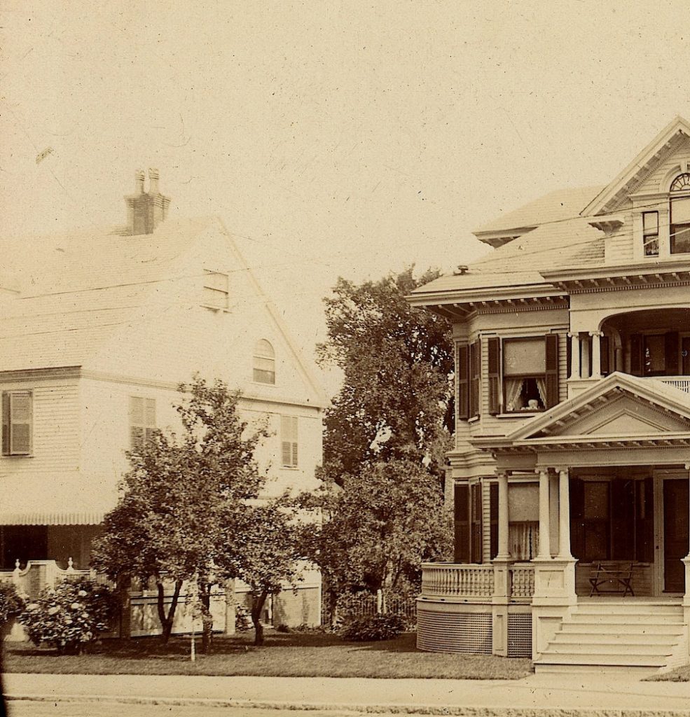
An Old Photo of Abbie Foster’s House, 74 High Street, looking towards Horton Street

An old photo of 74 High Street Courtesy of the Newburyport Archival Center

An old photo of 74 High Street Courtesy of the Newburyport Archival Center

An old photo of 74 High Street Courtesy of the Newburyport Archival Center

Sharon Spieldenner from the Archival Center at the Newburyport Library (I love, love, love the Archival Center) found an old photo of Abbie Foster’s house and sent it to me. There are two posts on Abbie Foster one all about her and that she built this fancy mansion at 74 High Street in 1895, and a second one on how she came up with the money to pay for her glorious Queen Anne fancy mansion.

Sharon didn’t know the exact date of the old photo of 74 High, but it looks like it’s early. I love it, I think it’s so cool, so wonderful and so thoughtful of Sharon and the Archival Center to keep their eyes open for Abbie’s house.

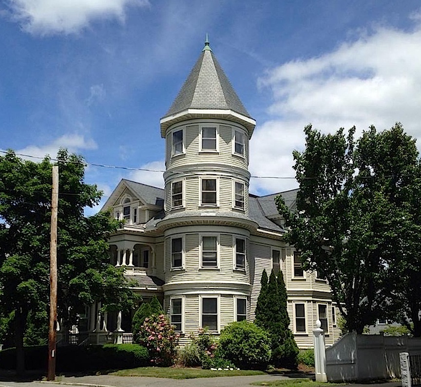
And this is what 74 High Street looks like today.

What 74 High Street looks like today

What 74 High Street looks like today

What 74 High Street looks like today

There is a little street behind 74 High  called Foster Court, named after Abbie Foster, that looks towards Horton Street (and there is a post all about Horton Street on The Newburyport Blog). In the old photo there is a field, a beautiful field. Here is the detail of the photo.

A detail of the field behind 74 HIgh Street

A detail of the field behind 74 HIgh Street

A detail of the field behind 74 HIgh Street

This is what that field, now Foster Court, looks like today. It looks a little different. And you can see the same house at the very end that is in the old photo, which is 9 Horton Street. (It is possible to make out two other houses that look  the same as well.)

Looking towards Horton Street today

Looking towards Horton Street today

Looking towards Horton Street today

And here is a closeup of 9 Horton Street today. It’s almost exactly the same as when it was built in 1890. I love it.

9 Horton Street today

9 Horton Street today

 9 Horton Street today

And here is photo of 76 High Street which is on the left of the old photo. It looks to me as if it is the same house and has been expanded.

76 High Street

76 High Street

76 High Street

And here is a detail of the edge of the old photograph from the Archival Center with 76 High Street on it.

A detail of the photograph with the side of 76 High Street

A detail of the photograph with the side of 76 High Street

A detail of the photograph with the side of 76 High Street

And here is a detail with the house itself.

Detail of 74 High Street

Detail of 74 High Street

Detail of the photograph of 74 High Street with just the house

_______________________________________________

Please read the original post all about Abbie Foster here.

The Two Schoolhouses that Once were near Frog Pond on the Bartlet Mall, Newburyport, MA

The School House and Pond Street, Bartlet Mall, Newburyport, MA

The School House and Pond Street, Bartlet Mall, Newburyport, MA

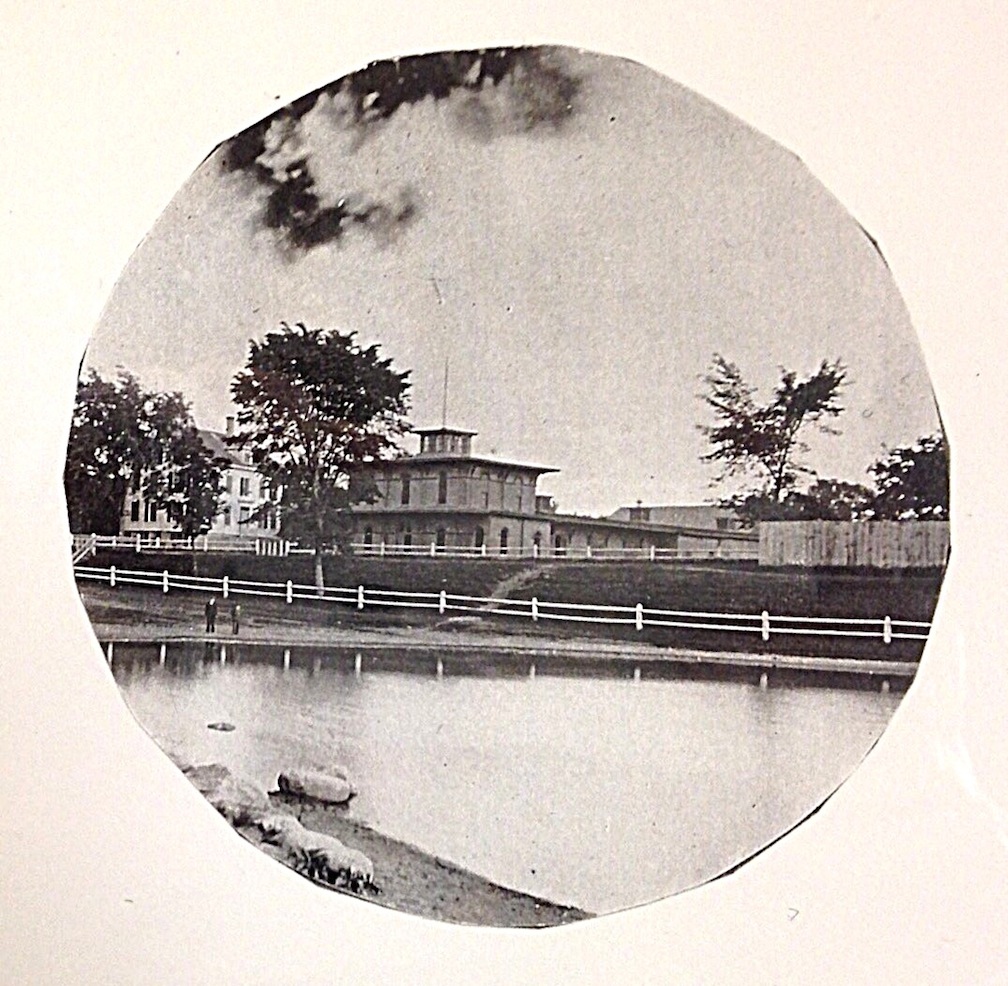
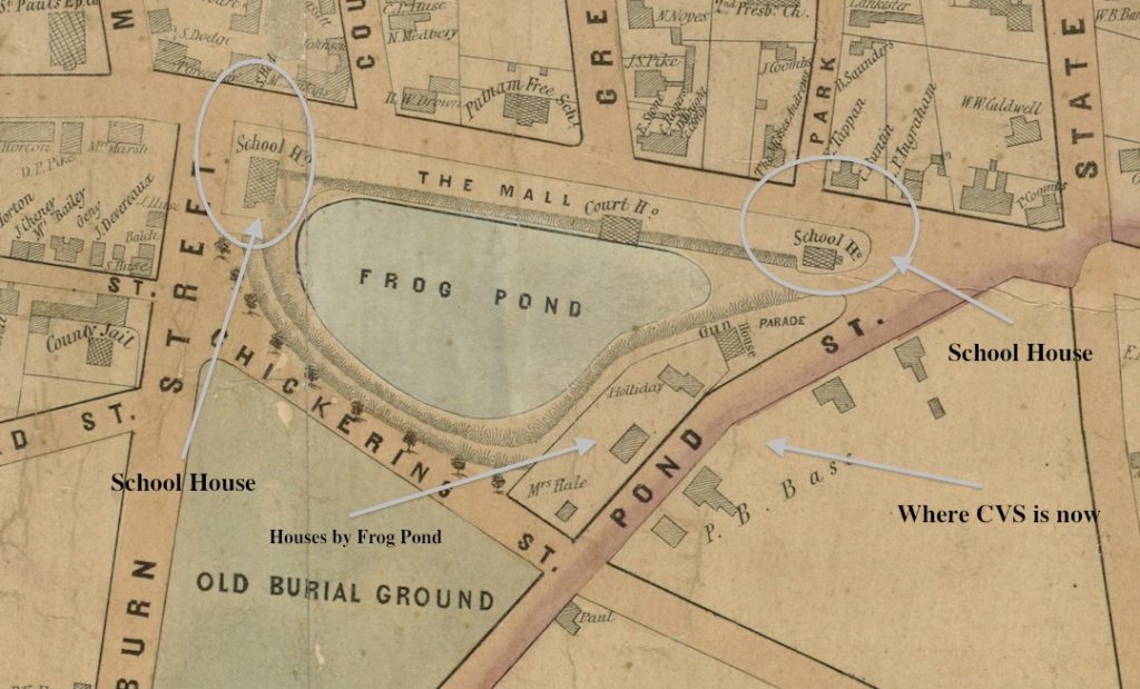
When I ended up researching Pond Street, on the 1851 map there are a lot of things on Bartlet Mall which do not exist today, including two schoolhouses. I went on a hunt at the Newburyport Archival Center at the Library and I found a wealth of photos that I had never, ever seen before of Frog Pond and the Bartlet Mall. I never knew that there was one schoolhouse on the Bartlet Mall, much less two.

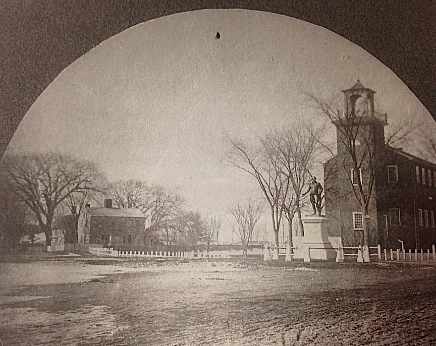
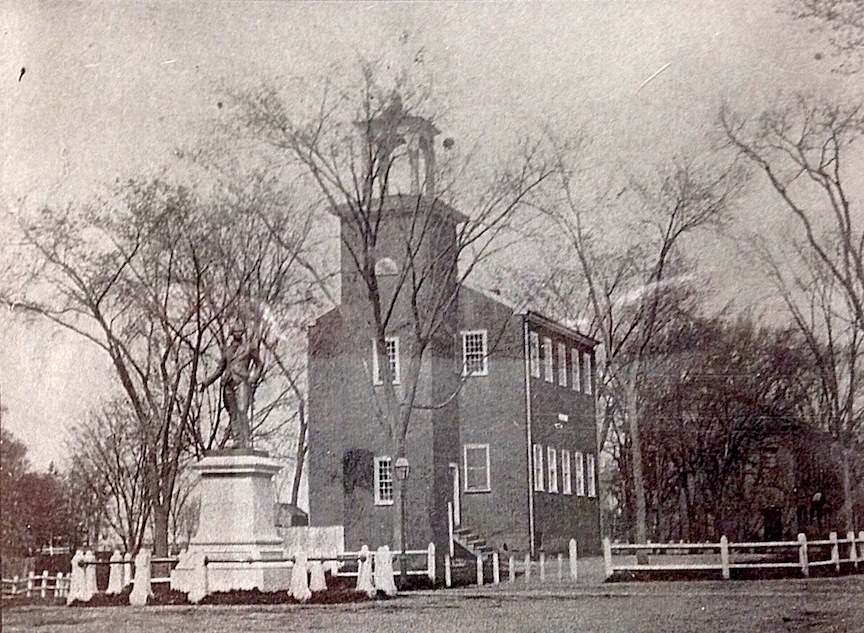
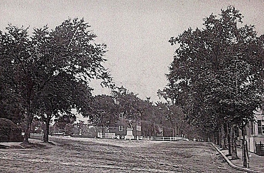
The photograph at the top of the post shows the school house at the “southerly end” of the Mall, the statue of George Washington in front, and at the left, the center chimney two story house where Stephen Hooper lived  (see previous post).

The 1851 map that shows the two schoolhouses and the houses along Frog Pond.

1851 Map showing the schoolhouses

1851 Map showing the schoolhouses

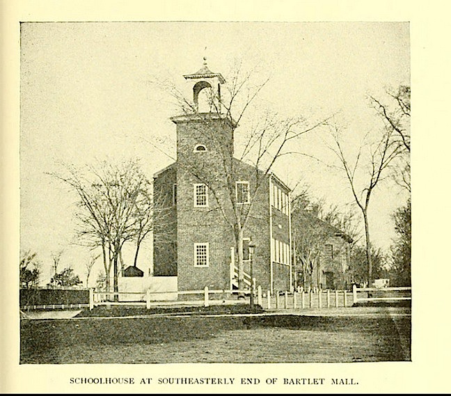
In 1796 the good people of Newburyport voted to build a brick schoolhouse at the “southerly end” of the Mall on land owned by the town near Frog Pond.  A second story was added to the schoolhouse in 1809.*

The 1796 Schoolhouse, from the “History of Newburyport Mass: 1764-1905, Volume 1,”  by John James Currier

The 1796 Schoolhouse

The 1796 Schoolhouse from the “History of Newburyport Mass: 1764-1905, Volume 1,” by John James Currier

The front of the 1796 School house, courtesy of the Archival Center, the Newburyport Public Library.

The 1796 Schoolhouse courtesy of the Newburyport Archival Center

The 1796 Schoolhouse courtesy of the Newburyport Archival Center

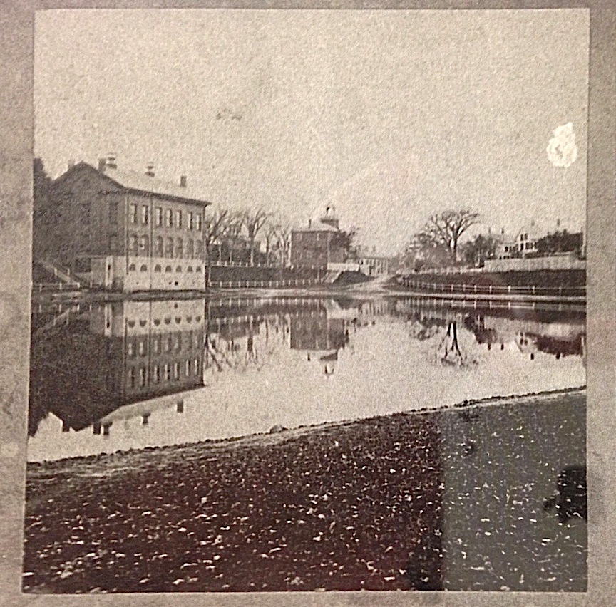
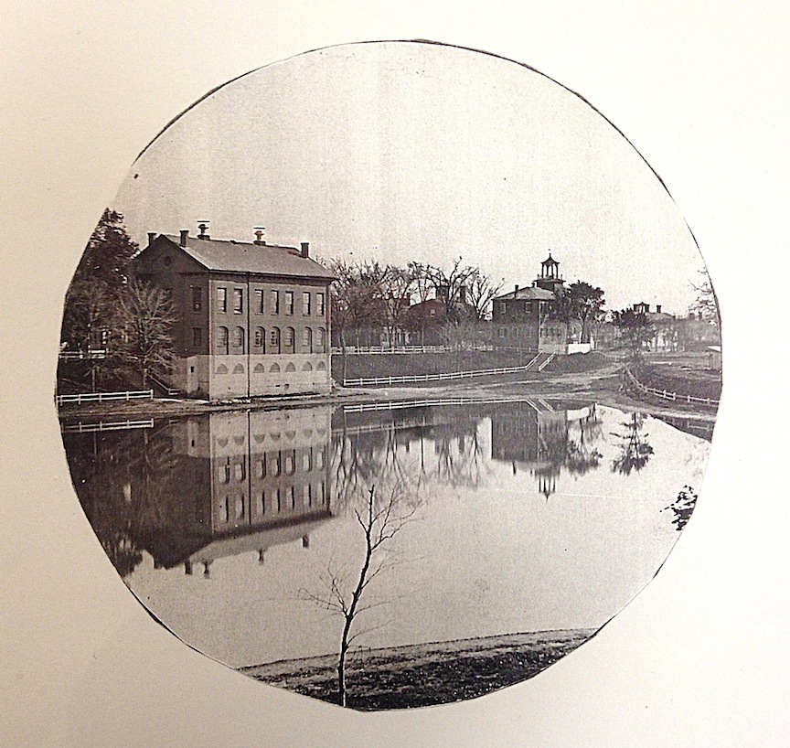
The back of the 1796 Schoolhouse, courtesy of the Archival Center, the Newburyport Public Library.  The Courthouse is in front.

The back of the 1796 School house, courtesy of the Archival Center, the Newburyport Public Library.

The back of the 1796 School house, courtesy of the Archival Center, the Newburyport Public Library.

The back of the 1796 School house, Frog Pond and the Courthouse courtesy of the Archival Center, the Newburyport Public Library.

The back of the 1796 School house, Frog Pond and the Courthouse courtesy of the Archival Center, the Newburyport Public Library.

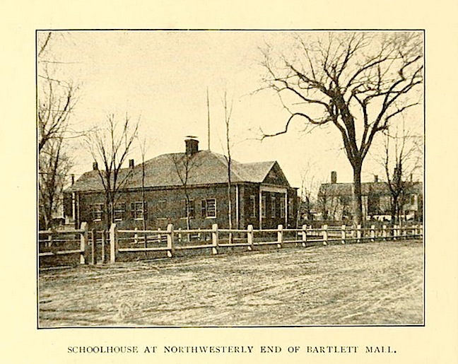
And in 1823 a new brick school building was built on the northwesterly side of the Mall.*

The 1823 Schoolhouse, from the "History of Newburyport Mass: 1764-1905, Volume 1," by John James Currier

The 1823 Schoolhouse, from the “History of Newburyport Mass: 1764-1905, Volume 1,” by John James Currier

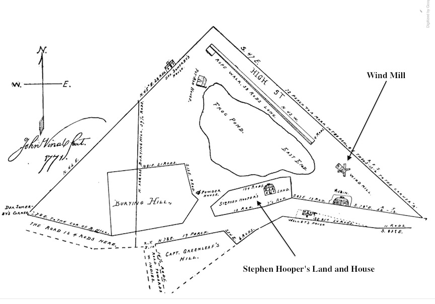
The windmill (that can been seen on the 1771 survey of Frog Pond) was moved near the burying ground in 1774, when the hill was cut down as a training field.*

The 1771 survey of Frog Pond from "History of Newburyport Mass: 1764-1905, Volume 1," by John James Currier

The 1771 survey of Frog Pond from “History of Newburyport Mass: 1764-1905, Volume 1,” by John James Currier

.
The statue of George Washington was given to the city in 1878 by Daniel I. Tenney, a Newburyport jeweler and silversmith, with a rededication ceremony in 1879 on George Washington’s birthday.*

In 1868 the one-story school house was destroyed by a fire. And in1883 the two-story brick schoolhouse was sold at auction and taken down the following summer. And in 1882, the house owned by Stephen Hooper (see previous post) was sold and removed.*

State and High Street with Pond Street on the left.

State and High Street with Pond Street on the left courtesy of the Newburyport Archival Center.

State and High Street with Pond Street on the left courtesy of the Newburyport Archival Center.

This is a detail of a photograph from the Archival Center at the Newburyport Library taken from State Street that shows High Street on the right and Pond Street on the left. The streets look like they are possibly dirt or gravel and not paved the way that the roads are today. The statue of George Washington and the schoolhouse are in the center.

I look at the two story schoolhouse in back of the George Washington statue and think how much we would value that building today. It breaks my heart that it was removed because I love, love, love it, and I wonder how many different ways we could think to re-purposed that beautiful building in this particular moment in time.

The houses on Frog Pond, courtesy of the Archival Center at the Newburyport Public Library.

The houses on Frog Pond, courtesy of the Archival Center at the Newburyport Public Library

The houses on Frog Pond, courtesy of the Archival Center at the Newburyport Public Library

And here are the houses that were on Frog Pond (for more detail see previous post). A lot of people, including me, wondered about the houses behind the ones on Frog Pond that were eventually taken down. And they still exist – 17 Pond Street, 19-21 Pond Street and 23 Pond Street which today, if you are standing in front of CVS are to the right towards Low Street.

17 Pond Street, 19-21 Pond Street and 23 Pond Street today.

17 Pond Street, 19-21 Pond Street and 23 Pond Street today

17 Pond Street, 19-21 Pond Street and 23 Pond Street today, Google Maps

*”History of Newburyport Mass: 1764-1905, Volume 1,”  by John James Currier

Romance, Politics, the Civil War Statue and a House on Pond Street, Newburyport, MA

Civil War Statue at Atkinson Common - Newburyport, MA

Atkinson Common – Newburyport, MA. Detail of a photograph by Scott Patterson of the Civil War Statue (found on flickr, the Creative Commons (CC) license)

One of the things that I love about “If This House Could Talk,” is that the stories that were told were not of Newburyport residences who Newburyport tends to think of as “rare and important,” but of folks, regular folks who had compelling stories, and people who had long been forgotten and who were remembered once more.  In looking for the next story, I was researching the Civil War statue at Atkinson Common and came across a name, “Walter B. Hopkinson,” and I thought, “Let’s find out about him.”

Atkinson Common, courtesy of the Archival Center at the Newburyport Public Library

Atkinson Common, courtesy of the Archival Center at the Newburyport Public Library

Alice Tappan Whittier Hopkinson

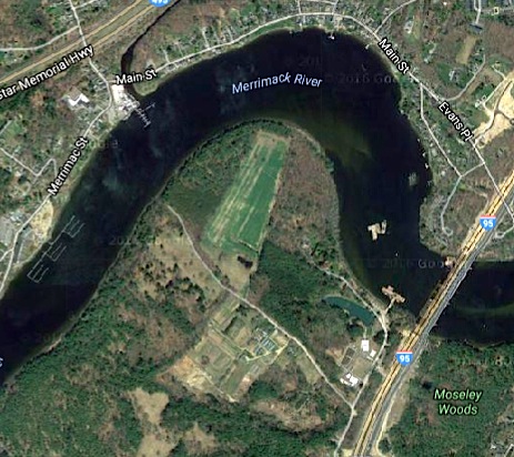
Walter B. Hopkinson was born in 1866 and was the son of William N. Hopkinson who served in the Civil War and lived at 339 High Street. As a very young man Walter married Alice Tappan Whittier. They lived at Bartlett Spring Farm, which if you go towards Maudslay State Park from Three Roads on Ferry Road, and go right (instead of left towards Maudslay) over the bridge, you end up where the the MerrimacK River bends towards the mouth of the river, and that is where the farm was located. It must have been gorgeous.  Alice, who was described as a “lady of rare accomplishments and universally beloved,” died in 1898, leaving young Walter Hopkinson a widow.

Where Bartlett Spring Farm would have been,

Where Bartlett Spring Farm would have been, Google Maps

Eleanor S. Hopkinson

Evidently Walter fell in love again, this time with his younger sister’s good friend Eleanor Robinson.  Walter was very much involved with the Republican party. And I found this wonderful story in The Chicago Tribune, Friday, June 22, 1900.

“THE CONVENTION BRIDE

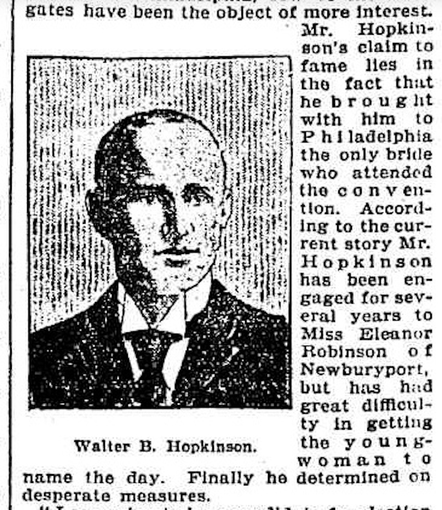
Although Walter B. Hopkinson of Newburyport , Mass., has not attracted great attention on the floor of the Republican convention at Philadelphia, few of the delegates have the object of more interest. Mr. Hopkinson’s claim to fame lies in the fact that he brought with him to Philadelphia  the only bride who attended the convention. According to the current story Mr. Hopkinson has been engaged for several years to Miss Eleanor Robinson of Newburyport, but has had great difficulty in getting the young woman to name the day. Finally he determined on desperate measures. “I am going to be a candidate for election as a delegate to the National convention.” he said one evening. “If you will consent to fixing our marriage at an early enough date I will take you with me if I am chosen.” Miss Eleanor consented, and then Mr. Hopkinson had a bad week or two, during which time he feared he might not be successful in getting the appointment. He was finally chosen, however, and the couple ate their wedding breakfast in Philadelphia last Monday morning. After the breakfast some of the Massachusetts delegation heard how matters stood and arranged a reception, which was attended by all the Massachusetts men, including Senator Lodge, who made handsome little speech of congratulation. National Committeeman Sam Fessenden of Connecticut, and other notables. Since the reception Mrs. Hopkinson has been known as the  ‘convention bride.’ ”

The Chicago Tribune: Friday, June 22, 1900

Walter B. Hopkinson, from the 1900 Chicago Tribune

Walter B. Hopkinson, from the 1900 Chicago Tribune

Walter B. Hopkinson was the 42nd mayor of Newburyport

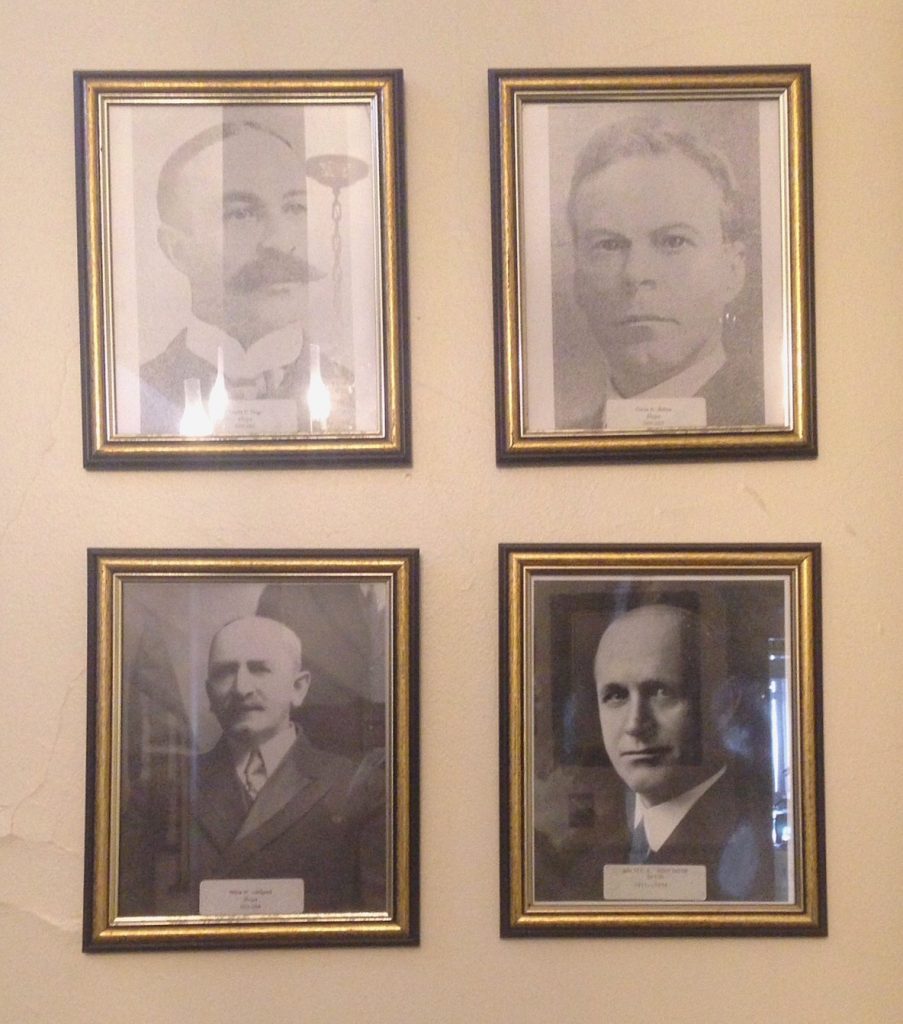
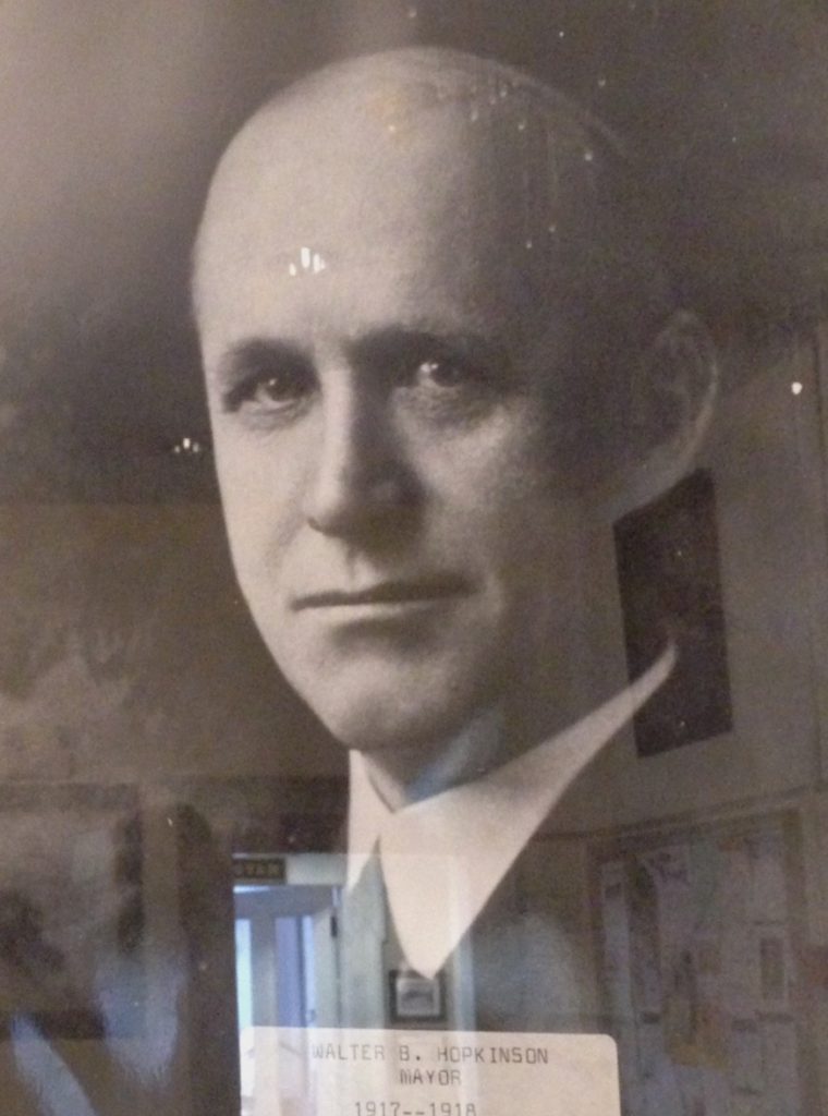
I found out by chance in my search that Walter B. Hopkinson also became the 42nd mayor of Newburyport from 1917-1918. Apparently at the time he was “rare and important” –  just now completely forgotten, who knew? So I went to the Archival Center at the Newburyport Public Library where they have a history, written by Todd Woodworth, of all the mayors of Newburyport, and yup, Walter B. Hopkinson turns out the be a very important person in the history of our city. Again, who knew? And how quickly “we forget.” Walter’s portrait hangs in the foyer in City Hall, right by the stairs on the right hand side as you go upstairs.

It turns out that Walter was a descendant of one of the first settlers of Newbury (this is a very big deal). He was a tea importer, employed by a Boston firm for 40 years and was president of that firm for 12 years. He was mayor of Newburyport during World War I, from 1917-1918. And he was chairman of the committee which presented the Civil War Volunteer monument at Atkinson Common to the city, as well as presenting the Civil War tablets that are there. He researched records from all over the country to make sure that the list was accurate . Walter was also a Republican delegate to the national convention in Philadelphia in 1900 and an alternate delegate in 1904. And when he died all municipal flags were flown at half-mast, and the members of the city council met at City Hall and went to the funeral together. He died in 1946.

Portraits of four mayors of Newburyport, Walter B. Hopkinson is the portrait on the lower right hand side.

Portraits of four mayors of Newburyport, Walter B. Hopkinson is the portrait on the lower right hand side.

Portrait of Walter B. Hopkinson at Newburyport City Hall

Portrait of Walter B. Hopkinson at Newburyport City Hall

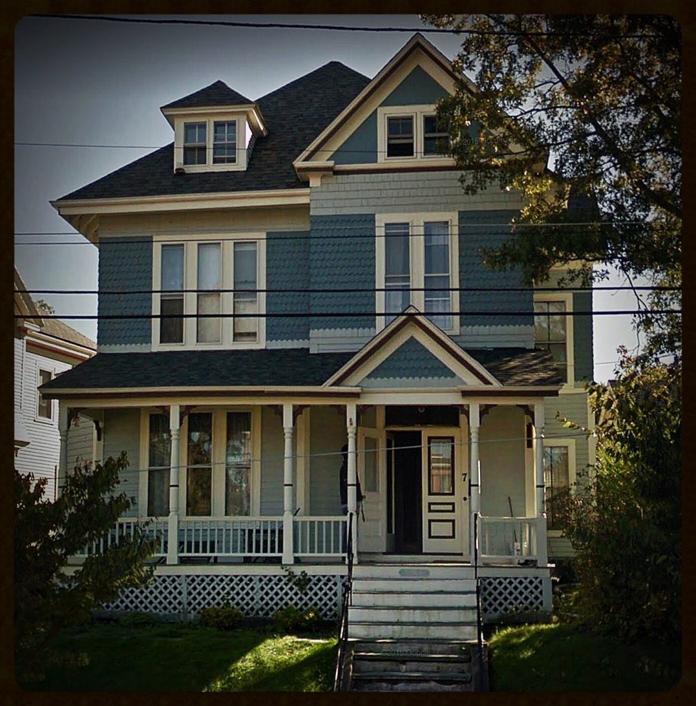
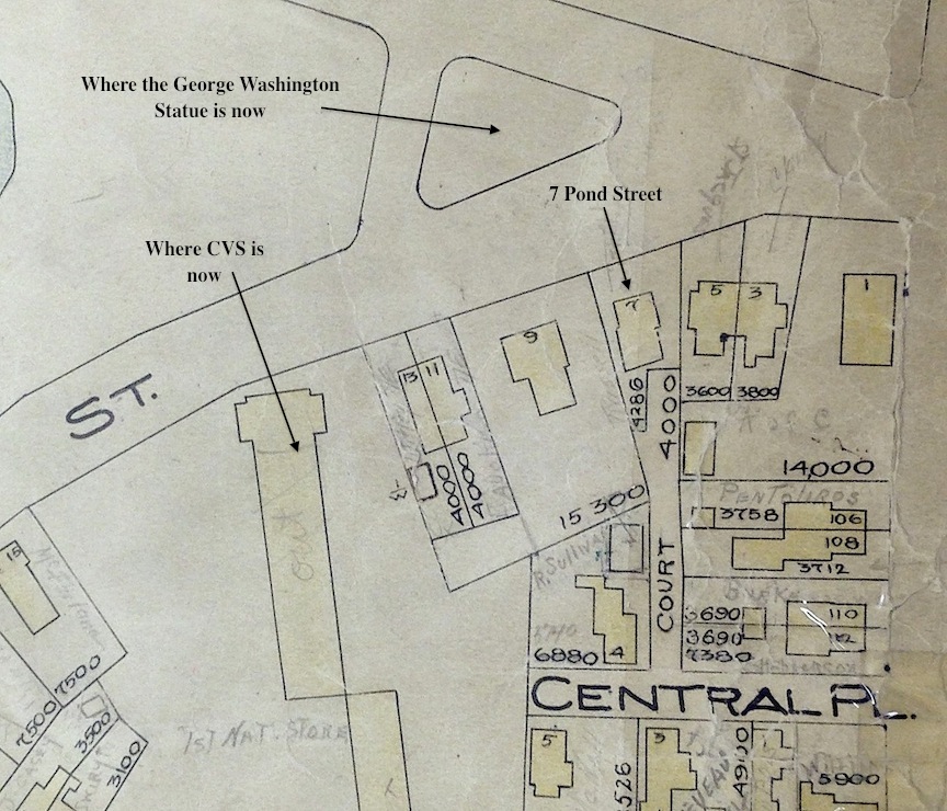
7 Pond Street

Walter and Eleanor lived at Bartlett Spring Farm, and in 1905 decide to move into town. They move to a lovely Victorian Queen Anne house, built around 1881 at 7 Pond Street. What’s really interesting is that the deed is not in Walter’s name, but is in Eleanor’s name and it stays that way until she, as a widow sells the home in 1949.  It is given to Eleanor for a dollar by Chauncey Dodge of the Newburyport Dodge Shoemaking empire (the story there – I have no idea, but another instance of a woman being given a piece of property for one dollar, like Abbie Foster of 74 High Street).

7 Pond Street, Newburyport, MA

7 Pond Street, Newburyport, MA – Google Maps

Everything is Infill

I went on a map hunt for Pond Street which is by the Bartlet Mall.  In the 1851 Map of Pond Pond Street and a large area close to Frog Pond is completely undeveloped.  According to the map, there is a school house where the George Washington statue now exists. Frog Pond is a different shape, and there are houses right next to Frog Pond.

1851 MAP

1851 Map

1851 Map

In the 1872 map, the railroad had come into the area (where CVS is now), but the lot where 7 Pond Street will be built is still empty. Walter and Eleanor’s house was built around 1881 and was part of 3 plots that were sold at that time.

1872 MAP

The Mall 1872 map

The Mall 1872 map

Detail of the 1872 map

Detail of the 1872 map

The 1924 map from the Newburyport City Assessors Office shows the area completely built up, and you can see where 7 Pond Street is located, along with the other three “developments,” three other beautiful Queen Anne homes.

1924 MAP

The 1924 map

The 1924 map

Detail of the 1924 map

Detail of the 1924 map

Walter B. Hopkinson’s story is now on the Newburyport Interactive History/Story map which can be found at map.historynewburyport.com

167 Water Street, Newburyport – Gordon Welchman (and Bossy Gillis too)

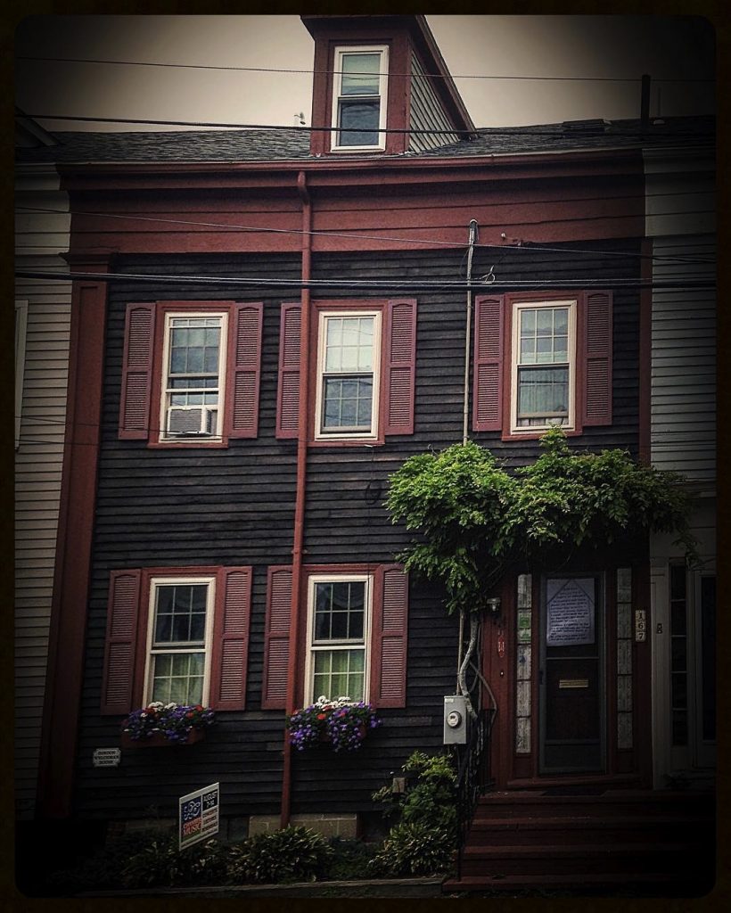
167 Water Street

167 Water Street

167 Water Street

This is another story discovered from “If This House Could Talk-Newburyport” – 167 Water Street.

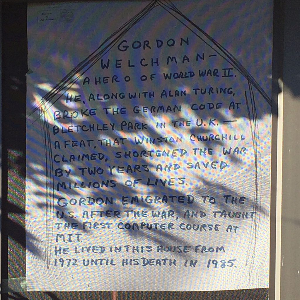
167 Water Street, poster for “If This House Could Talk”

167 Water Street, poster for "If This House Could Talk"

167 Water Street, poster for “If This House Could Talk”

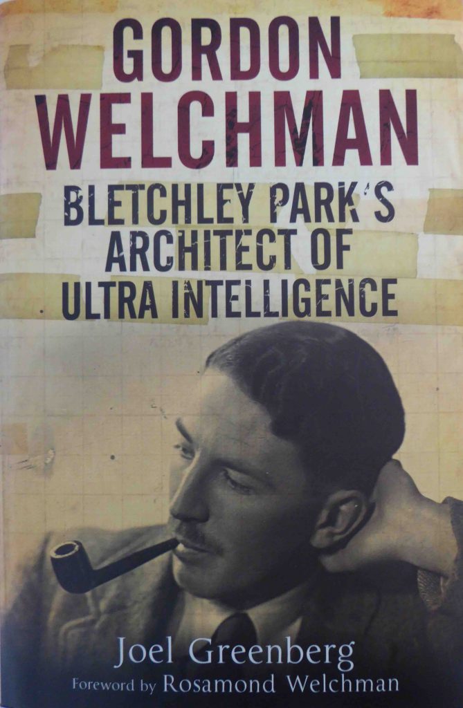
For those who remember the film “The Imitation Game” which was about how the German code was broken in during World War II, there was one person who was there and who was left out of the film – Gordon Welchman, a hero who along with his colleagues shortened the war by two years and saved millions of lives.  There is a recent documentary in 2015 by the BBC called “Bletchley Park: Code-breaking’s Forgotten Genius” about Gordon Welchman. It was aired on the Smithsonian Channel as “The Codebreaker Who Hacked Hitler.”

Book on Gordon Welchman

Book on Gordon Welchman

Book on Gordon Welchman

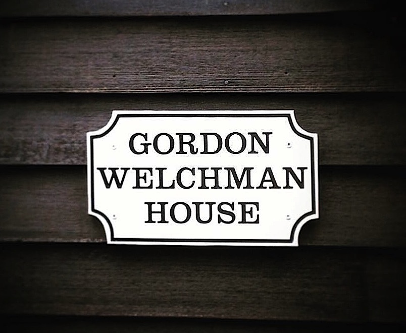
Gordon Welchman is a fascinating person and a very big deal. He moved to America and became an American citizen. In 1972 he moved to Newburyport and bought 167 Water Street. He died here in 1985. 167 Water Street is now a B&B and has a Gordon Welchman plaque.

Plaque for Gordon Welchman on 167 Water Street

Plaque for Gordon Welchman on 167 Water Street

Plaque for Gordon Welchman on 167 Water Street

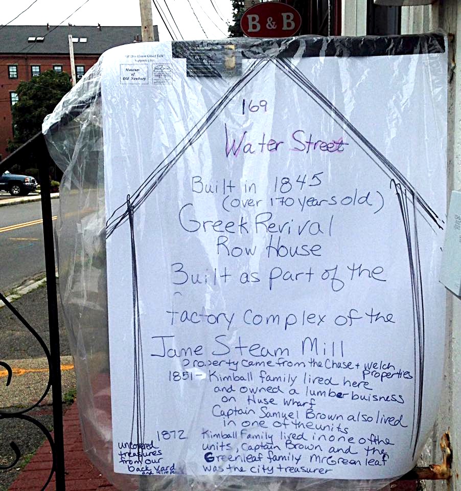
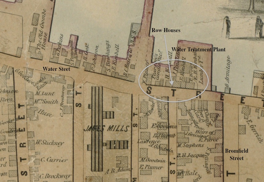
The house next door was also part of “If This House Could Talk” and their sign gives the the information that the Greek Revival Row House (which includes where Gordon Welchman lived) was built in 1845 and was part of the factory complex of the James Steam Mill.

Poster for 169 Water Street – “If This House Could Talk”

Poster for 169 Water Street - "If This House Could Talk"

Poster for 169 Water Street – “If This House Could Talk”

1851 Map Showing Row Houses on Water Street

1851 Map Showing Row Houses on Water Street

1851 Map Showing Row Houses on Water Street

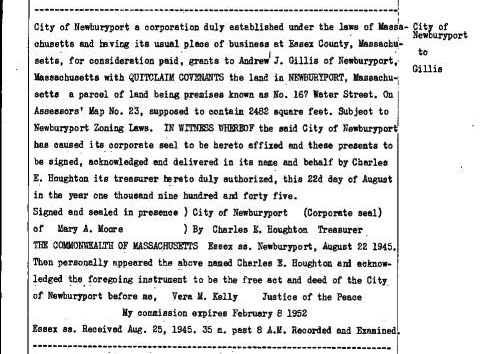
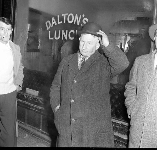
And in my hunt to find out a little bit more about 167 Water Street I discovered that in 1945 it was bought from the City of Newburyport by Bossy Gillis a multi-time mayor of Newburyport (Bossy Gillis has had books written about him – another big deal). And during “If This House Could Talk-Newburyport” Yankee Homecoming 2016, it turns out that Bossy Gillis owned two other properties that were documented in this very cool project. It doesn’t appear that Bossy Gillis actually lived at 167 Water Street, I’m guessing that he rented it out.

Bossy Gillis 1945 Deed for 167 Water Street

Bossy Gillis 1945 Deed for 167 Water Street

Bossy Gillis 1945 Deed for 167 Water Street

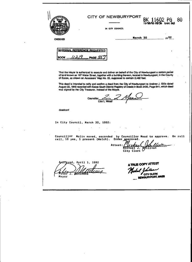
And the last fascinating tidbit that I found was that Bossy Gillis’s deed in 1945 was signed by the treasurer of Newburyport not the Mayor.  And 1992 it was brought before the City Council for clarification. The person who sponsored it was then City Councilor and future mayor Lisa Mead. Then City Councilor (and former mayor)  Ed Molin moved that it be approved and was then signed by mayor Peter Matthews. (There may be a story about Bossy Gillis’s 1945 deed, maybe a clerical error, I do not know.)

1992 Deed Claification by the Newburyport City Council

1992 Deed Claification by the Newburyport City Council

1992 Deed Claification by the Newburyport City Council

Bossy Gillis

Bossy Gillis

Bossy Gillis

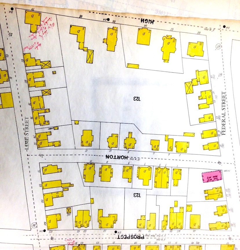
Everything is Infill, Horton Street, Newburyport, MA

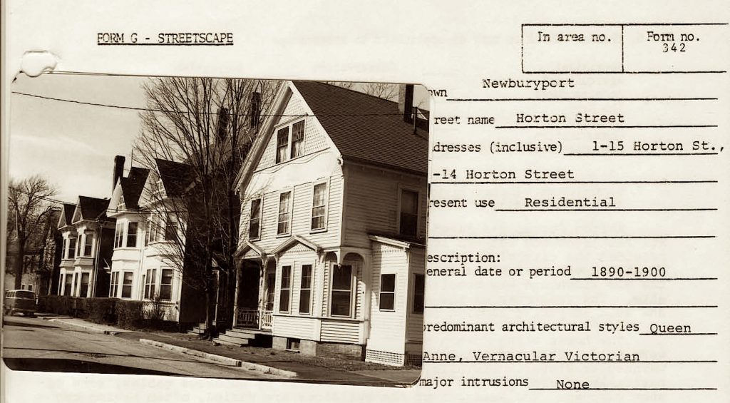
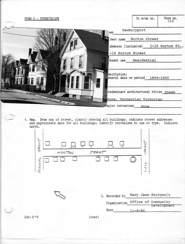
Horton Street form the Newburyport Historic Surveys.

Horton Street from the Newburyport Historic Surveys.

Doing research for “If This House Could Talk” (which was/is awesome) I learned a lot about our neighborhood.  Horton Street is a small Street that is just below High Street and runs between Federal and Lime Street.

THE OLD ALMSHOUSE

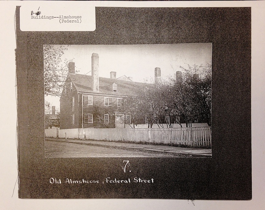
The old Almshouse, built in 1794, Newburyport, MA

The old Almshouse, built in 1794, Newburyport, MA

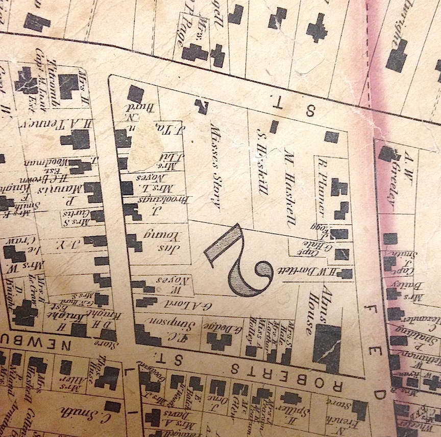
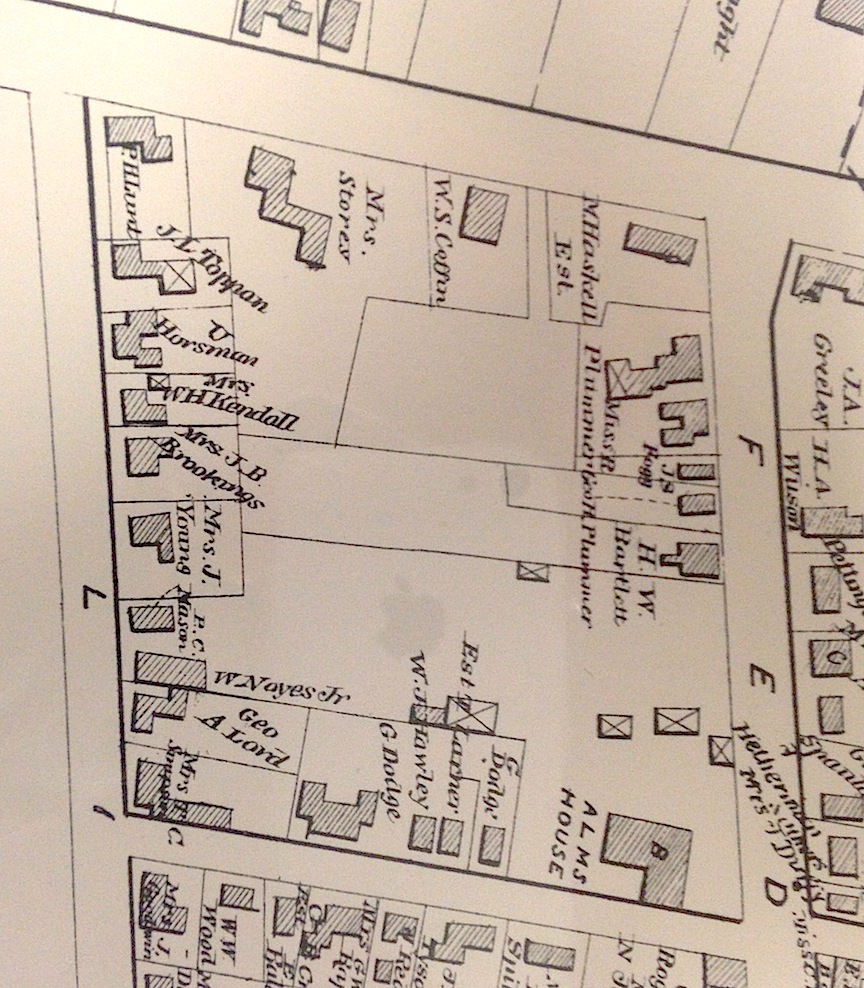
Most of that area was owned by the City of Newburyport and that is where the old Almshouse used to be with its gardens and orchards going all the way back to almost Lime Street. The old Almshouse was built in 1794 and was on the corner of what is now Prospect and Federal Streets. The Newburyport Archival Center has a photo of it, and the building looks gorgeous.

THE NEWBURYPORT HISTORIC SURVEY ON HORTON STREET

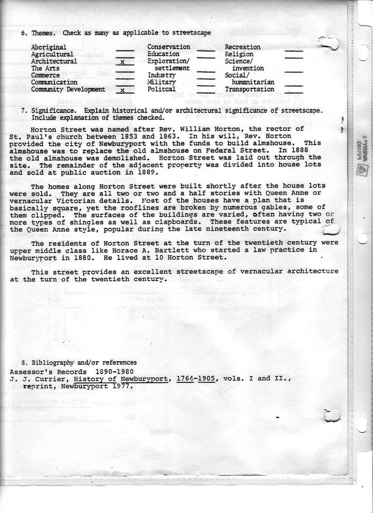
Horton Street, Newburyport HIstoric Surveys

Horton Street, Newburyport HIstoric Surveys Page 1

Horton Street, Newburyport HIstoric Surveys Page 2

Horton Street, Newburyport HIstoric Surveys Page 2

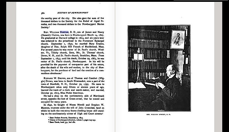
Reverend Horton left money in his will for a new Almshouse, and the old was was demolished in 1888. Horton Street was laid out in 1889.

REV. WILLIAM HORTON

Rev. William Horton

Rev. William Horton

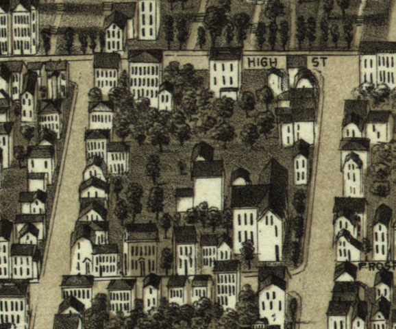
The old Almshouse shows up on various maps.

1872 MAP

1872 Map showing the old Almshouse

1872 Map showing the old Almshouse

1884 MAP

1884 Map showing the old Almshouse

1884 Map showing the old Almshouse

1880 BIRDS EYE MAP

1880 Birds Eye Map showing the Old Almshouse

1880 Birds Eye Map showing the Old Almshouse

And then I found a 1900 map that show all the houses, all the new development, the incredible infill that had been built pretty much all at once on Horton Street and also along Federal Street and part of Prospect Street where the old Almshouse had once been.

1900 MAP

1900 Map showing Horon Street and all the new development

1900 Map showing Horon Street and all the new development

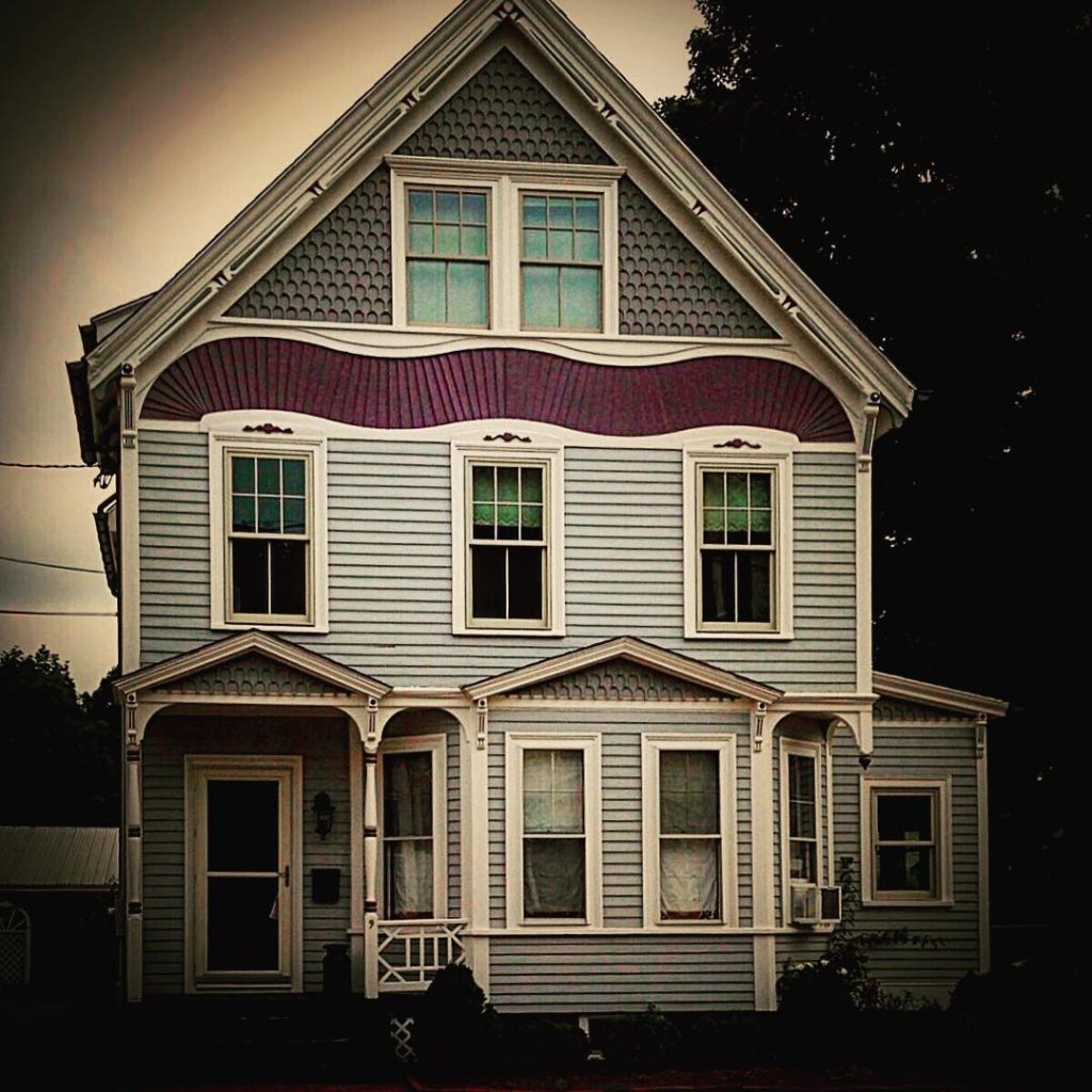
ONE OF THE HOUSES BUILT ON HORTON STREET

Horton Street House

Horton Street House

The House that Abbie Built, Newburyport, MA, Abbie L. Currier, Abbie L. Foster 1846-1913

The house that Abbie Built

Abbie L. Foster's House, 74 High Street Newburyport, MA

Abbie L. Foster’s House, 74 High Street Newburyport, MA

Abbie Foster seems to be one of those forgotten people with an intriguing story, and the story so far has a huge hole. In 1895 Abbie Foster built a HUGE Victorian McMansion on High Street. I’ve figured out a whole lot about Abbie Foster, but not how she got an astounding amount of money at age 49 to build that glorious Queen Anne house.

I started to get curious about all of this thanks to Jack Santo’s project of “If This House Could Talk.” Jack is trying to get folks to write something very short about their house and put it on a poster board during this year’s Yankee Homecoming so that folks can walk around Newburyport and learn about the city’s history. It’s very cool.

I started to look into the history not only of my house but of our little Newburyport neighborhood.

In our neighborhood there is a short little dead-end street called Foster Court, and I found out that it was named after a woman, Abbie Foster.  I don’t know of any street in Newburyport that is named after a woman, so I wanted to know more.

Abbie Foster was born in Newburyport to David Currier a shoe maker and his wife Mary Currier in 1846. They were working/middle class folks, Abbie had one brother and two sisters. Her sister Helen Currier never married and they lived together all of their lives, either with their parents, then boarding with their mother and after their mother’s death, together.

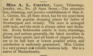
I found an article in a 1886-1887 city directory about a “Fancy Goods” shop downtown, “A. L. Currier” and yup, that’s Abbie. Here it is:

Miss A. L. Currier, Laces, Trimmings, Jewelry, etc., No. 58 State Street. –The attractive lace, trimming, and jewelry establishment of Miss A. L. Currier, No. 58 State street (where the Book Rack is now, on the corner of Pleasant and State Streets), has for ten years been one of the popular shopping places for ladies of Newburyport and vicinity.  The store is arranged with taste, and the stock is always select and desirable.  Every fashionable article in laces, trimmings, gloves, and notions generally, the latest novelties in ladies’ fancy goods, and all kinds of elegant jewelry, are to be had here at lowest possible prices, and satisfaction is uniformly guaranteed.  Miss Currier is a very prompt and reliable business lady.  She is a native of Massachusetts.”

A description of Abbie's store from a 1886 City Directory

A description of Abbie’s store from a 1886 City Directory

Abbie was single until she was 44, and in 1891 she married Daniel Foster who was 60. This was Daniel’s second marriage, there were no children from his first. He came back to Newburyport in 1887 and seems to have boarded in different places, including where Abbie’s family lived, which was 14 Spring Street.  Daniel died in 1893 only 2+ years after they were married.  Abbie was a widow for 20 more years.

AFTER Daniel dies, in 1894 the heirs of Solomon Haskell and Mark Haskell gave Abbie the land that she built her house on on High Street and the land that what was once known as Haskell field and is now known as Foster Court. They gave the land to her for $1. Abbie gives the right of way to the City of Newburyport in 1898 and it is named after her because she owns the land. Foster Court does not show up on any map until 1940.

The first question I had was why in the world would these folks give land for a $1 to Abbie?  I talked to Ghlee Woodworth and Melissa Berry and they both suggested that there was probably a family connection between the Curriers and the Haskells. And yup, after a lot of digging around, there was a connection, and I’m going with that they were distant cousins, and they gave her the land. It’s the only thing that makes any sense.

And Ghlee Woodworth and Sharon from the Newburyport the Archival Center went and looked in City Hall for the tax records, and Abbie starts paying taxes on the land in 1896, which probably means she probably built the house in 1895, however, she did not take out a mortgage, so she must have built it with cash?  The tax records show that the house was worth $9,000 which in todays’ money is somewhere around $250,000 and $300,000 but the house itself in today’s market would be well over a million dollars. It’s a fancy place.  Abbie did take out a mortgage for $10,000 from the Institution for Savings in 1910. I have no idea why.

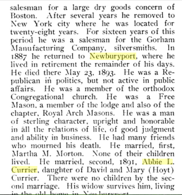
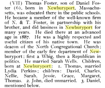
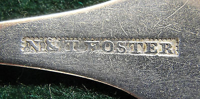
I looked into Daniel Foster, her husband, thinking maybe the money came from him. But if he had that kind of money, why did he board all those years, why not buy a house. I’ve included the write-up of Daniel as well as the write-up of Daniel’s father Thomas Foster, who among other things was a Revolutionary War hero, and owned N & T Foster with his brother Nathaniel Foster downtown in the building that is now called the Phoenix Building. Nathaniel was a clock and watch maker, and Thomas was one of the “old time” silver smiths, before Towle Silver existed, and many people apprenticed with him.  I thought the  money might have come from there. Some obviously did, but Thomas had a whole lot of children beside Daniel. I haven’t found Daniel’s will yet, it sounds like there was money, but not that kind of money, not the kind of money to build a High Street fancy mansion.

A write-up on Daniel Foster

A write-up on Daniel Foster

A write-up on Daniel Foster

A write-up on Daniel Foster’s Father, Thomas Foster

A write-up on Daniel Foster's Father, Thomas Foster

A write-up on Daniel Foster’s Father, Thomas Foster

Mark of N&T Foster Silver, Newburyport, MA

Mark of N&T Foster Silver, Newburyport, MA

The other person I thought might have helped Abbie was her brother Warren Currier who lived at 190 High Street.  Among other things he was Mayor of Newburyport from 1873-1874 and was a partner in Summer, Swasey and Currier a very successful shipping merchant business at 45 Water Street. I did find Warren’s will, and he gave Abbie maybe around $1,000, big bucks, but not enough money to build a $9,000 house on High Street.

Helen Currier, her unmarried sister who lives with her all her life and dies in 1901, living at 74 High Street, had first been a school teacher and then the principal at a school on School Street (I’m assuming it was or became the Jackman School). I looked up the salary of a woman teacher and it was miserable, enough to help support her mother and father, but not much more than that. No money there.

So Abbie builds this spectacular house at 74 High Street. The 1900 census shows that she lives there with her sister and a servant.  The 1910 census shows that she is living alone in that great big house with one servant. She lives there for 17 years. This is far, far away from where she grew up as a shoe-maker’s daughter.

And I found someone who knew someone who remembered Abbie, someone who lived in the neighborhood. He referred to her as “Old Lady Foster.” Abbie was in her 50’s and 60’s when she was referred to as “Old Lady Foster.”

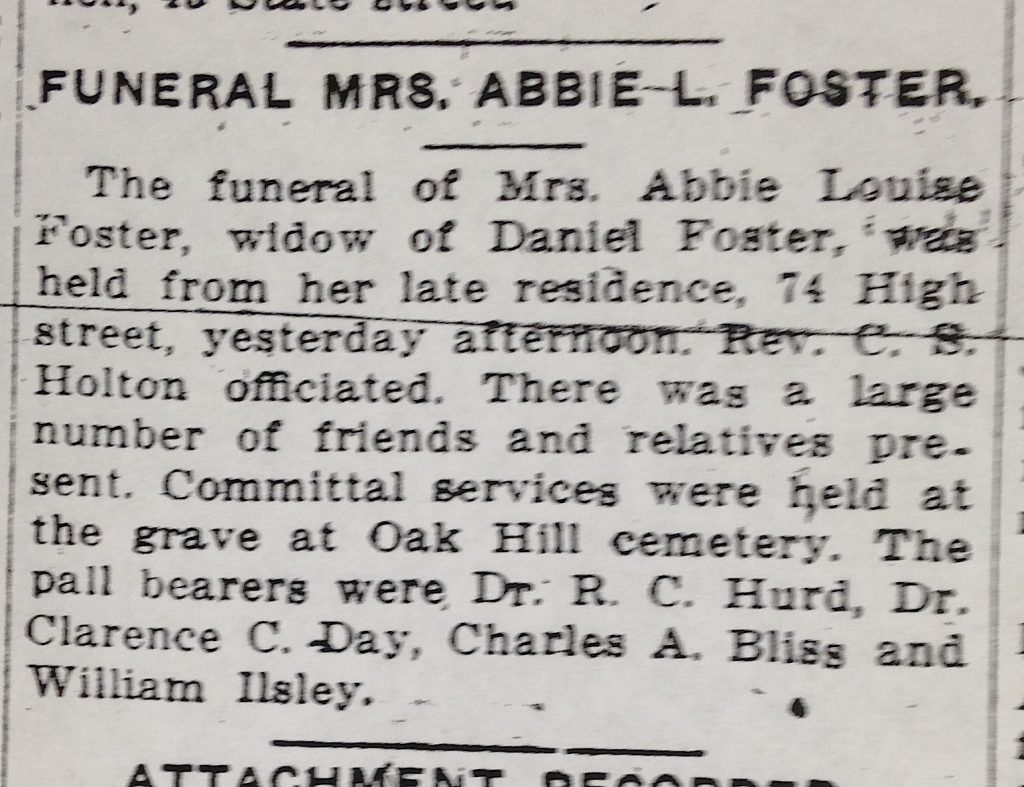
And I found a write-up of her funeral. Not an obituary, and no obituary for her sister Helen.  A write-up. Here it is:  “The funeral of Mrs. Abbie Louise Foster, widow of Daniel Foster was held from her late residence, 74 High street, yesterday afternoon. Rev. C. S. Holton officiated. There was a large number of friends and relatives present.”  The pallbearers were her doctor, another doctor in town, her neighbor at 62 High Street and a clerk at one of the banks. No family.  It doesn’t include any glowing details of how wonderful she was, what church and organizations she belonged to the way many of the write-ups in the newspapers seemed to do (at least all the ones I saw when I was going on a hunt for Abbie’s obituary).

The write-up of Abbie Foster's funeral

The write-up of Abbie Foster’s funeral

And I asked around at the Archival Center at the Newburyport Library as to what folks thought it meant. I know when I moved here in 1981 there was still a very strong class system here in Newburyport. There was still the upper crust on High Street and then everyone else, and it was even more pronounced earlier in the century. “Old Lady Foster” for me is kind of a derogatory term. Maybe she “made it” and was accepted by the folks on High Street, or maybe not. I’m hoping that when the old newspapers from the 1890’s which are being digitalized by the Library’s Archival Center come back sometime this summer, maybe I’ll know more. Maybe I’ll find out some more answers about Abbie Foster and the house she built on High Street and where she got all that money.

Many thanks to the Newburyport Library’s Archival Center and all the wonderful people who work and volunteer there. I found a lot of stuff on Google and FamilySearch.org is pretty amazing along with Salem Deeds online, salemdeeds.com.

____________________________________________________________________________

With more research I found out Where Abbie Foster got the money to build 74 High Street. (Hint it was her husband Daniel Foster, and it’s a great story so please read it.)

And here is the link to a post about the beautiful Old Photo of Abbie Foster’s House, taken from High Street but looking towards Horton Street and Foster Court. Sharon from the Archival Center found it. The Archival Center at the Newburyport Library is amazing.

An old photo of 74 High Street Courtesy of the Newburyport Archival Center

An old photo of 74 High Street , the house that Abbie Foster built, Courtesy of the Newburyport Archival Center

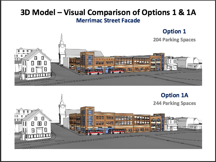
A Tale of the 204 Newburyport Parking Garage

204 & 244 Newburyport Parking Garage Comparison

204 & 244 Newburyport Parking Garage Comparison

I watched (I thought I wouldn’t, but I did, I just couldn’t help myself) Monday night when the parking garage vote came to the floor of the Newburyport City Council. Is this riveting stuff? it was to me. In the ongoing 41 year hoped-for/battle for a parking garage in Newburyport, the choice had come down to  244 space, a 204 space or a “no” space parking garage. Having counted the votes for a 244 garage (8 out of 11 votes were required), 8 votes simply did not exist, but would those folks who so desperately wanted a 244 settle for the smaller number or let a parking garage die yet one more time in its 41 year old quest.

City Councilor Bob Cronin put a motion (I don’t know what the technical term is) on the floor for a 204 garage.  It was immediately amended to a 244 — sudden death in the making. Councilor Jared Eigerman very calmly asked the 244 folks, that if they did amend to a 244 would they be willing to have no garage. The answer to Councilor Eigerman’s question was apparently “no” because somehow “it” got amended back to a 204 garage.

And then the speeches commenced. My favorite was probably Councilor Joe Devlin’s who read a long, long list of all the insults that had come his way (and he was by no means alone) including being called a misogynist (a misogynist over a garage–really?? Yes, actually really — bat-shit crazy, but really) and ended up his speech assuring the good people of Newburyport that if a large civic project came to their back yard the City Council would have their back. The theme of the strong 204 folks, Bob Cronin, Larry Guinta, Sharif Zeid, Greg Earls and yes, Joe Devlin, was that the people of Newburyport who were most affected by the garage, the abutters, were their major concern.

And then somewhere after lots of speeches a 244 seemed to be being thought about again, and Councilor Jared Eigerman one more time, very calmly reminded the 244 folks that he was only counting 5 votes for their cause — 8 votes not there. The vote for the 204 garage took place with a few grudging “yes” votes,  and after 41 years the Newburyport City Council made history, by taking an incremental step, getting 100 cars off the Waterfront, and moving Newburyport one small to medium step towards its future.

Congratulations to this Newburyport City Council — a job well done.
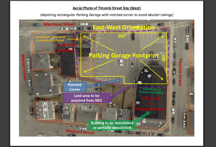
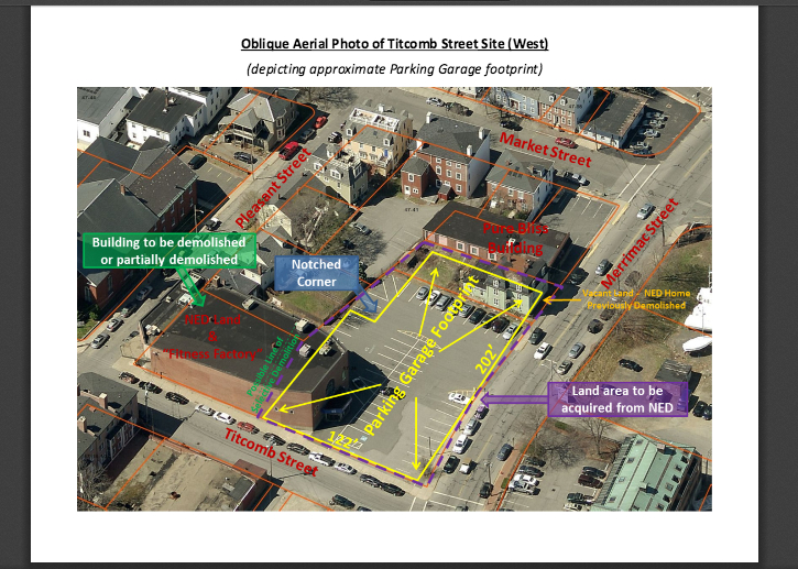
Newburyport Proposed Parking Garage

Proposed Newburyport Parking Garage footprint

Proposed Newburyport Parking Garage footprint

I admire all the Newburyport City Councilors for wrestling with the proposed Newburyport Parking Garage.  Here is a post from Newburyport Councilor at Large Joe Devlin on his thoughts about the garage and the process.  I appreciate Joe’s thoughtfulness on the subject. The post is from Councilor Devlin’s Facebook Page.
“Parking Garage Update: I have attended several public meetings with the abutters, residents, the mayor and the other members of the city council, the city’s parking consultant, the MVRTA and LAZ Management. I have communicated individually with abutters, local businesses, and Newburyport residents, as well as several professionals in the commercial construction industry. I have also reviewed numerous documents and studies, including those provided relative to the current project, and those from past efforts. To me, the issue boils down to the following questions:

1) Does the city need a garage?
2) Do residents want it?
3) Can we pay for it (now and in the future)?
4) Is this the appropriate location for it?

Initially, I have an issue with the information, both its form and timeliness, provided to councilors and the public alike. For example, although the MVRTA, along with its primary management company LAZ, operates several garage locations in Massachusetts, we were only given the annual budget and expense report for FY2015 and to December 31, 2015, for the MVRTA garage in Haverhill, MA. When councilors, including myself, asked about some numbers in the Haverhill budget that reflected badly on the garage and/or management (i.e. the actual budget through December 31, 2015 was 12.5% higher than the estimated annual expenses), we were told the Haverhill garage was not a good comparison to our city, begging the question why it was provided in the first place. In a report from the planning director, a timeline of the steps in the process to vote for the 100% design funds of $630,000 stated that the 30% design would be done first. However, in questioning the MVRTA representative at one meeting, I was informed that the 30% design had been halted in September of last year, due to the uncertainty with the size and scope of the project. These are just a few of the examples of the information provided.

1) “Do we need the garage?” One person’s “need” is another person’s “luxury”, and a garage is not necessarily a project that will have residents dancing in the streets. Studies of varying sophistication have been done over the years, the last in 2012, based on a study of parking on two days during the summer. Its first conclusion – “overall, the total on-street and off-street public parking system operates under effective capacity except for the infrequent, summer peak weekend condition and during special events” – matches most people’s observations. Despite talk of impending development that may affect our parking situation, a parking garage alone is not a trip generator. In other words, people don’t come here because we have a garage, but rather because we have interesting places to visit, shop and eat. A parking garage is a complement to a successful and prosperous business center, however. On the waterfront, we are also using valuable land in a less than optimal way, so for me, shifting some parking off the waterfront would be a good reason to build a garage.

2) “Do residents want it?” – Again, I do not believe a garage is something that will have residents dancing with joy in the streets. Generally, the people I have spoken to are somewhat in favor of building a garage – so long as it can be done economically and not use monies designated for other important public purposes. Councilor Ed Cameron sent out a survey to several hundred people, and 53.2% of the respondents favored a garage. The Chamber of Commerce polled downtown business, and 57% were in favor of the garage, although at the time of the report from the Chamber a good portion of the businesses had not responded. However, important aspects of making the garage successful (i.e. profitable), have not yet been decided or vetted through the public. According to John Burke, the city’s parking consultant, parking restrictions have to be put in place within a 5 minute walk of the garage, a sea change in our parking structure that could negatively affect the residents’ view of the garage. In the 2012 traffic study, Burke equated a “5 minute” walk to 1200 feet. I walked from the site of the garage and made it past Olive Street to the west, and just past Fair Street to the east, which was approximately 1500 feet. In either event, a very large area of the city will be affected by new parking restrictions necessary to make the garage work.

3) “Can we pay for it?” – The major part of the plan to pay for the garage is to raise parking rates from $.50 to $1.00/hour. This would raise approximately an estimated $250,000.00 in parking revenue if the parking demand remains constant. We have been given projections for the next 10 years, but they make numerous assumptions that may, or may not, come to fruition. As the parking garage is the only variable we can control, and the parking garage is not a trip generator, the conservative approach is to make this decision assuming parking remains the same. Everything else is just a guess, and I do not want to spend the public’s money that way. It has also been argued that we have excess funds ($261,920.00 last year) from the parking program each year to go to overruns and losses, but that money currently goes to downtown improvements, so a loss of that money to fund the garage would mean the parking garage was not a success.

4) “Is this the right location?” – I believe this is the second best location for a parking garage, behind Green Street. I also do not believe it is a location of sufficient size or proximity to address all of our future parking needs. We have several areas of the downtown – call them “West”, “Central” and “East” – and this location will only help the first two. “East Downtown”, from State Street to the Tannery, also has parking needs that can not be addressed by a location at this distance. Sinking all of our money into this location, then, would be short-sighted and tie our hands for future needs.

This is also the most intensive use of the Titcomb/Merrimack parcel under our zoning code, with the highest allowable height and no required setbacks. In plain language, it means we can build something that takes up the entire lot right to its edges, and go higher than any other use there. That is a lot to ask of the neighbors, abutters and area of the city. The height for the 244 space garage is also larger than any other structure in the area, and does not fit into the historical character of that part of the city. Putting so much money into such a small spot, which provides no room to expand horizontally, also neglects the parking needs of other parts of the city east of State Street.

To me, the fact that the Green Street lot is always the first lot to be filled attests to the desirability of the location for businesses and customers, it has the most room for future expansion and is surrounded by buildings of significant height. However, we have been told that we are in danger of losing the $2,000,000.00 in Federal funds, which I verified at a public meeting with the representative of the MVRTA, if we do not authorize $630,000.00 for final design by March 31, 2016. To that end, I am unable to further explore the design of a similar-sized garage at Green Street.

The city council is being asked to put the cart before the horse on this matter, in voting on $630,000 for final design before, among other things, we have the information from the 30% preliminary design, any binding vote from the NRA on removing spaces from the waterfront, and an initial plan for parking restrictions, vetted by the public who will be affected. However, the prospect of losing $2,000,000.00 in Federal funds means a “no” vote on the final design funds would also lose the Federal money that, in my mind, are essential for me to even consider the project.

I did not create the problem with this deadline: it has been 6 years since the city council and Mayor voted on the Titcomb street site, and the preliminary design was halted several months before I was elected. However, it is solely based on the prospect of losing the Federal funds, that I, along with Councilors Cronin and Zaid, have proposed a vote to approve the $630,000.00 for final design of a 204 space parking garage. The height of the 204 space is almost 6 feet lower than the 244 proposal and 10.5 feet lower at the elevator tower, and the scale and massing of the 204 space garage is more in-line with the historical architecture of that part of the city. The $3,600,000.00 bond also gives us the most margin for error in case the garage is not financially as successful as we all hope, and flexibility in pricing, parking restrictions and addressing future parking needs in other parts of the city. Most importantly, it will allow us to make a significant reduction of at least 100 parking spots from the NRA lots.

The initial proposal for the garage would have cost a total of $16,000,000.00, with $9,000,000.00 coming from the city. Our proposal achieves two major goals, the building of a centralized parking structure to serve the western part of the downtown and the removal of parking from the waterfront lots. It does so at the most minimal investment to the city, giving us a sizable structure for approximately .33 cents on the dollar. It also allows us to take advantage of the $2,000,000.00 in Federal funds, despite the inadequate time given us to fully vet this particular project.

Please feel free to give me and the other councilors your thoughts and questions on this proposal. Thank you.

Joe”

To contact Joe Devlin please see his Facebook Page.

Proposed Newburyport Parking Garage footprint

Proposed Newburyport Parking Garage footprint


An Amendment to the 40R Smart Growth District that Would Make it Pedestrian Friendly Sooner Rather than Later

I am relieved.

One of my many concerns about Newburyport’s 40R Smart Growth District (SGD) around the Traffic Circle is that the goal is to make the area pedestrian friendly, and it is one of the most dangerous, if not the most dangerous area for any pedestrian in the city. There is no safe way to get from State Street over to the Train Station or visa versa.  There were some vague  promises that the area would be addressed, but there was never anything ever from MassDOT saying, yup, this is exactly what we are planning to do to remedy the situation and this is when we are going to do it.

Area in the Proposed Amendment to the 40R Smart Growth District

Area in the Proposed Amendment to the 40R Smart Growth District

Along comes Newburyport City Councilor Jared Eigerman with a proposed amendment, to temporarily put on hold a small area of the 40R SGD, to encourage the state to come to the table and improve that area of Rt. 1 so that it is finally SAFE.  Yeah!! I cannot tell you how much I appreciate this from Councilor Eigerman, along with the co-sponsor of the amendment, City Councilor Bob Cronin.

There are a couple of maps in this post that outlines the parcels/area in question.

And there is absolutely no reason not to do this.

1) This would not affect anyone’s property rights, as I understand it, the old zoning in that smaller area would apply, until the state made sure it was safe to get to the Train Station from that small but crucial area, and then the 40R zoning would kick back in.

2) It would not affect affordable housing, the 40R still has a bundle of space to build in, until this particular issue is addressed, and then it would be safe to get from the Train Station to State Street, so that it would then actually make some sense to build more housing units on State Street, because it would then be pedestrian friendly.

3) It would not jeopardize the 40R Smart Growth District in any way.

4) And this concept came from the Commonwealth of Massachusetts, so why in the world would the state not want to step up to the plate sooner rather than later, to make this whole area, their concept, happen in the way that it was intended.

Area in the Proposed Amendment to the 40R Smart Growth District

Area in the Proposed Amendment to the 40R Smart Growth District

I wrote all of my Newburyport City Councilors and Mayor Holaday expressing my enthusiasm for this proposal, and except for a few responses, it’s been “radio silence,” which concerns me.

Below is the amendment drafted by Councilor Eigerman that went before the City Council and is now in committee.

“4. Intersection of State and Parker Streets. Notwithstanding anything to the contrary in this Zoning Ordinance, until such time as the City’s Director of Public Services certifies to the City Council that U.S Route 1 has been rebuilt, reconfigured, retrofitted, or otherwise improved to ensure safe pedestrian access across U.S. Route 1 within the SGD and south of Parker Street, development of a Project pursuant to this Section shall not permitted at any of the following parcels located near the intersection of State Street and Parker Street: Parcel 34-5 (165 State Street); Parcel 34-6 (3 Parker Street); Parcel 34-9-A (4 Parker Street); Parcel 34-11 (163-165 State Street); Parcel 34-12 (161 State Street); and Parcel 34-13 (151-155 State Street).”

The different parcels are marked on the maps.

Is it possible for historic preservation to have gray areas? Not to be absolutely black and white?

Is it possible for historic preservation to have gray areas?  Not to be absolutely black and white?

The subject here is windows.

I’ve lived in old houses, and quite frankly old windows, in the houses I’ve lived in, were hard to get up and down. But the joy of looking through old pane wavy glass windows is remarkable. I’ve seen friends who did a beautiful restoration and put in new windows, their delight when they showed me how easy they were to put up and down was palatable.

When I talk to historic preservationists, the impression I often get is that keeping old windows is the only way to go. I found this article on the web, a website for old houses, and it discusses the pros and cons of keeping old windows.  And remarkably it is nonjudgmental.  It is one of the best and most balanced articles that I’ve ever read.

Window with pansies, digital image © Mary Baker

Window with pansies, digital image © Mary Baker

Restore or Replace? The Options for Old Windows

Many old homes boast their original wood windows, and in some cases, the architectural detail is magnificent. Unfortunately, the older the windows are, the less likely they are energy-efficient. Upgrading the windows means either restoring them to their original condition or opting for replacement windows.

Window Replacement or Restoration?

Deciding between window replacement and window restoration can be a tough choice. Study the pros and cons of each option before you make a decision.

Replacement Windows

•    Replacement windows can be well-insulated, cutting down on energy costs and noise.
•    You can open the windows with minimal effort, and they stay open, unlike old windows with no springs or pulley systems.
•    You can replicate the architectural designs of old windows, although extensive designs might become a bit pricey.
•    Efficient, thorough weather stripping is a given on new replacement windows.
•    You can install replacement windows quickly, which leads to less disruption for those who live there.
•    Removing the existing windows can damage the surrounding wallboards, stucco, or plaster and can lead to expensive repairs.
•    Replacement windows with pulley systems, bubbled glass, and other historic details necessitate a custom order and can become very expensive.
•    If you are seeking a landmark or historic designation, reviews of the window replacement details can take quite a bit of time, and might hold up the work schedule.

Window Restoration

•    The original materials and design are preserved.
•    Most historic windows were built of durable wood taken from large trees, and in some cases, those woods are now extremely rare–some species have died out or are not plentiful enough for new construction.
•    Any damage to the surrounding area during a restoration is minimal, and usually only cosmetic.
•    Unique, beautiful original glass details can be left undisturbed.
•    If the windows are in good shape to begin with, restoration might be surprisingly affordable.
•    If the historic windows are single-pane, simply restoring them provides no significant energy savings.
•    Restoration can take a great deal of time.
•    Old windows are often painted with lead paint and require costly, specialized removal.

Doing it Right

Professional installation for replacement windows is a must to ensure the full value of energy-efficient upgrades. If you choose to restore the windows instead, restoration professionals can make certain your windows are as secure and energy-efficient as possible while maintaining all the unique features so important to a historic home.

Whether you choose to replace or restore the beautiful windows in your old home, hire a professional to get the job done right!

About the Author
Shannon Dauphin is a freelance writer based near Nashville, Tennessee. Her house was built in 1901, so home repair and renovation have become her hobbies.

77 Lime Street

77 Lime Street, a before and after comparison

77 Lime Street from Prospect Street, a before and after comparison (the before photograph is from Google maps)

The rancor over the renovation on 77 Lime Street mystifies me.

This is the deliberation from the ZBA meeting in June of 2014:

Mr. Ciampitti commented on the thorough and detailed presentation. He agreed that it is rare to see a historic structure renovation with a reduction in massing and scale. The proposed alteration will exacerbate non-conformities and increases open space. This is hard to do! He was prepared to support.

Mr. LaBay agreed. He commented that there were no neighbors appearing in opposition. Both Mr. Harris and Ms. Niketic noted the sensitivity of the owner to historic structures.

Mr. Pennington agreed. The presentation was well articulated. His only concern coming in was intense massing, and that was not the case. It will be a successful project in the way in the addition is distinct and not to be confused with the original historic structure. He was prepared to support.

A year later, a member of the ZBA had this to say:

Mr. LaBay was pained to have to say that this was not what he thought we were approving a year ago.

And someone speaking at that meeting had was, “angered and saddened driving by this rehab.”

I think for this particular project it was one of expectations.  The historic preservationists in town expected the renovation to be done a certain way, it was not done the way that they had expected.  It was done differently. There has been a renovation of a house on High Street that was done exactly the same way, the expectations of historic preservationists were “low,” I think, and I’ve heard good to great things about the results.

And as a btw, one of the many things that historic preservationists are upset about is that the windows on the third floor are not the original size. I asked, and that is because, if a renovation exceeds a certain percentage, code kicks in, and modern code calls for larger windows, that is why larger windows are on the third floor. And the windows are painted black instead of white (which is the new “thing” for windows), and I think the black color makes them look larger, although (and I asked), except for the third floor, they are exacly the same size.

I’ve put a side by side comparison of the before and after comparisons of 77 Lime Street from Prospsect Street, and I am by no means horrified by the results.

77 LIme from Lime Street, compare before and after

77 LIme from Lime Street, compare before and after, before image is from Google Maps

Editor’s Note: And I’ve just included the before and after comparisons of 77 Lime Street from Lime Street. The before image is from Google Maps.

And I’ve known Gus Harrington and his wife Sue for over 30 years.  Among other things Gus works at Historic New England, previously known as the Society for the Preservation of New England Antiquities (SPNEA).  Gus is the owner of 77 Lime Street and I’ve talked to him a great deal on my daily walks. I live in the neighborhood and take a walk through Newburyport’s South End every day, and 77 Lime Street is on my “route.”  I have been constantly curious about this project and try and ask questions and have a dialogue about the process. And because I know and trust Gus, maybe I’ve been more open minded.  I think an ongoing dialogue and “listening” on any project is important for community harmony, something that I strive for and is often difficult and at times down right impossible to achieve.  But we are a community, and I would much rather have constructive dialogue and an effort to problem-solve than community animosity.

Historic Preservation was once Revolutionary, Elegant and Sexy

Yup, historic preservation was once revolutionary, elegant and sexy.

When The National Historic Preservation Act was passed in 1966 (see previous post) it was revolutionary.  Historic preservation became the means of reclaiming America from the onslaught of bulldozers, reclaiming its past. Fighting the demolition of Urban Renewal became a noble and heroic act.

“We do not use bombs to destroy irreplaceable structures related to the story of America’s civilization. We use the corrosion of neglect or the thrust of bulldozers… Connections between successive generations of Americans are broken by demolition. Sources of memory cease to exist.” – Albert Rains, who helped prompt the passage of the National Historic Preservation Act of 1966

And then there was Jacqueline Kennedy Onassis, who when she was first lady, restored the White House to its former glory and saved Washington’s Lafayette Square from being replaced by ugly government office buildings in the early 1960s.

Jacqueline Kennedy Onassis

Jacqueline Kennedy Onassis

And in 1975 Mrs Onassis stepped up to the plate and helped save Grand Central Station, a  symbol of old Manhattan, a city that her grandfather had helped build.

At a press conference for Grand Central Terminal she said, “If we don’t care about our past we can’t have very much hope for our future. We’ve all heard that it’s too late, or that it has to happen, that it’s inevitable. But I don’t think that’s true. Because I think if there is a great effort, even if it’s the eleventh hour, then you can succeed and I know that’s what we’ll do.”

Grand Central Station, NYC

Grand Central Station, NYC

And writing to the mayor of  New York City she penned, “Dear Mayor Beame…is it not cruel to let our city die by degrees, stripped of all her proud moments, until there is nothing left of all her history and beauty to inspire our children? If they are not inspired by the past of our city, where will they find the strength to fight for her future? Americans care about their past, but for short term gain they ignore it and tear down everything that matters…”

Grand Central Terminal was saved.

The wonderful article that can be read here, describes her efforts as “subtle, genuine and classy.”

And we in Newburyport look back at the people who saved our downtown Newburyport in 1968 as heroes.

Restoring downtown Newburyport, from "A Measure of Change"

Restoring downtown Newburyport, from “A Measure of Change”

For years I’ve heard historic preservationists referred to as the “hysterical committee,” or some variation thereof (and recently I asked a person who used this term if it only applied to people in Newburyport, and what they said is, “No, preservationists all over Massachusetts are called that.”)  Somewhere along the way, historic preservationist went from being precieved as heroic and revolutionary, to being thought of as fussy and a nuisance, and quite frankly today, they/we are often on the defense, often losing, instead of on the offense and being identified as revolutionary and heroic.

Restoring downtown Newburyport, from "A Measure of Change"

Restoring downtown Newburyport, from “A Measure of Change”

(The photos of restoring downtown Newburypor are from the video, “A Measure of Change”)

In re-evaluating where historic preservation is in the 50th year of the passing of the The National Historic Preservation Act,  somehow historic preservationists need to get their Mojo back. We need a present day Jacqueline Kennedy Onassis, on the local and federal level.  It sometimes feels as if we are right back in 1975 when Jacqueline Kennedy Onassis wrote, “Americans care about their past, but for short term gain they ignore it and tear down everything that matters…”

Truman Nelson, Newburyport, Historic Preservation, a Lost Story

On one of the Facebook Newburyport groups Dick Sullivan (former City Councilor and mayoral candidate) mentioned that Truman Nelson had played a big part in the restoration of Newburyport during Urban Renewal.

My response was that I did not have a clue who Truman Nelson was.  Another member of the group said that he was on the video about Newburyport, “A Measure of Change.”

Truman Nelson from "A Measure of Change"

Truman Nelson from “A Measure of Change”

This is Truman Nelson, the photo is from “A Measure of Change.” I’ve seen that video a ton of times and had never questioned who in the world he was.

And it’s hard to find out information on Truman Nelson.  Going to Salem Deeds Online, Mr. Nelson owned 2 homes in Newburyport on Olive Street, 23 Olive and 15-17 Olive, both bought back in 1966, before Urban Renewal.  Dick Sullivan remembers Mr. Nelson’s family at 23 Olive and Tom Kolterjahn remembers going to Mr. Nelson’s house at 15-17 Olive to talk about how to renovate the old homes in Newburyport that people were working on.

23 Olive Street, Newburyport, MA

23 Olive Street, Newburyport, MA, Google Maps

23 Olive Street is described as, “One of the oldest homes in Newburyport; built 1699. Five working fireplaces,wide pine board floors, gunstock corners, beautiful moldings and trim. Full bath up half bath down.” The information is from Zillow.

15-17 Olive Street, Newburyport MA

15-17 Olive Street, Newburyport MA, Google Maps

15-17 Olive Street is the John Burrill House, c 1790, There is a write up on the Massachusetts Historic Commission, as well as on the Historic Surveys on the City of Newburyport’s website.

And in my hunt to find out exactly who Truman Nelson was, I found this writeup on Amazon, The Truman Nelson Reader:

“Truman Nelson (1911-1987) was a self-educated novelist, essayist, lecturer, and social activist. He never finished high school and supported himself in his early years as a factory worker, labor organizer, actor, and playwright. Encouraged by F. O. Matthiessen, he turned to writing and in 1952 published his first historical novel, The Sin of the Prophet, a study of Theodore Parker and the Anthony Burns case. That book earned him his picture on the cover of Saturday Review and designation as the magazine’s “Writer of the Year.” Two novels soon followed: The Passion by the Brook (1953), on George Ripley and the communal movement at Brook Farm, and The Surveyor (1960), on John Brown’s abolition efforts in Kansas. These three novels established Nelson as a major writer on the history of American radical thought. His later essays and polemical writings were influential in the civil rights movement of the 1960s, when Nelson traveled, taught, lectured, and acted in the front lines of the struggle for racial equality.

In recent years, Nelson has been neglected by scholars, critics, and the general public, and many of his writings have been allowed to go out of print. The Truman Nelson Reader is intended to restore his voice and to prompt a reevaluation of his work. The collection brings together excerpts from Nelson’s published novels, selected essays, and a portion of his last, as yet unpublished, novel on John Humphrey Noyes, founder of the Oneida Colony. Also included are essays on William Lloyd Garrison, Henry David Thoreau, John Brown, and W.E.B. Du Bois, as well as selections from the 1960s: “The Torture of Mothers,” written after the first Harlem riots; “The Right of Revolution,” reportedly found on Ho Chi Minh’s desk at the time of his death; and “The Conscience of the North,” a meditation on Theodore Parker’s meaning for the civil rights movement.”

The Truman Nelson Reader

The Truman Nelson Reader

And I found this reference to Truman Nelson on Martin Nicolaus’s website, where he refers to Mr. Nelson’s preserving his colonial-era home in Newburyport:

“One of the speakers at the Town Hall rally after the Cuba trip was Truman Nelson. He was a high school dropout who worked in General Electric factories until he was 40, but meanwhile educated himself during long hours in public libraries and began writing fiction. His first book, The Sin of the Prophet, was published by Little, Brown; it told the story of the abolitionist intellectual Theodore Parker. When I met him, Nelson had recently finished The Surveyor, a novel about John Brown and the Harper’s Ferry raid. He was fiercely interested in Cuba and was a strong supporter of Robert F. Williams. He had just bought a colonial-era house in Newburyport, a short drive from Boston, and was busy removing generations of old paint to reveal the beautiful old woodwork underneath.”

The Disappearing Newburyport Iconic Chimney

One of my most favorite small houses in the South End is getting a redo. As I looked inside, nosey person that I am, what was being taken out was the center chimney that ran up the middle of the house. And it was amazingly massive, as I walked by the next day and the chimney removing folks were still at it. They said that they were removing the chimney because it took up too much room in the new redo.

Newburyport, Chimney

Newburyport, Chimneys, Google Maps

And as I was taking a walk through Newburyport’s historic South End, I was looking up, and I began to realize that there were a lot of houses that no longer have chimneys. And one of the other things that I began to realize, is that in the Fall there is rarely that chimney smell, the smell of burning wood, that I used to notice when the weather fisrt started to turn chilly.  For a whole lot of reasons the Newburyport iconic chimney is beginning to disappear from the city’s street scapes.

Chimney, Newburyport

Chimneys, Newburyport, Google Maps

For me the chimney has always been a symbol of warmth, family, hearth, home. Houses with chimneys were in drawings by small children when they drew a picture of a family house, with the smoke going up the chimney. Santa comes down the chimney. Chimneys are a big part of what is important to historic preservationists and folks who love old towns and old homes, for a good reason, they are iconic.  Iconic New England historic houses have chimneys.

Chimney, Newburyport

Chimneys, Newburyport, Google Maps

The new heating systems no longer need chimneys. Chimneys take up a lot of room in a house.  Instead of creating ambiance, and being valued, they now seem to be a nuisance.  Chimneys are often in the middle of a house, which now gets in the way of a family having an open concept.  And compared to wood fireplaces, gas fireplaces are less  trouble, they might not smell as homey, but they are a whole lot easier — just a flick of a switch. Gas fireplaces can be put in a whole lot of places, and they don’t need chimneys. And not a whole lot of people cook in a fireplace anymore (oh, how I love those huge fireplaces in some of the old homes in Newburyport where people once cooked their meals). Times have changed and are changing.

Chimney, Newburyport MA

Chimneys, Newburyport, Google Maps

People who do renovations, a gut and redo, every now and then put up a “fake” chimney where the real one used to be.  These folks are often made fun of, but I would far prefer that, which is at least an attempt to keep Newburyport’s story, than many of the candy cane exhaust systems that I see sticking out of houses now as I walk around the South End.

New heating system, instead of chimneys, Newburyport

New heating system, instead of chimneys, Newburyport, Google Maps

The new heating systems, although wonderful in their efficiency, are one more thing that is slowly changing the historic city scape of Newburyport.  This change is fairly recent, when the Federal Street Overlay was created, not too long ago, chimneys were a “must have.”  Every home in the Federal Street Overlay has chimneys. Chimneys are no longer a “must have,” they have become an inconvenience.

Federal Street Overlay, Newburyport MA

Federal Street Overlay, Newburyport, Google Maps

And sometimes with these small incremental changes, it feels as if the historic fabric of Newburyport, Newburyport’s story is being shredded by a thousand papercuts. What is a historic preservationist to do?  How can we who love old homes and historic cities, inspire people to keep that part of the story, while also appreciating the practical reasons why this change is coming about.  More hard questions with no easy answers.