Category Archives: Planning and Development

Planning and Development, Newburyport, MA, urban planning, the design, construction and organization of Newburyport’s urban spaces, architecture and activities.

Well Loved Newburyport Postcards

Newburyport postcards–whether you’re a native, have lived here for a while or a short time,  people who live in Newburyport seem to love old postcards.

Newburyport Hay Stacks, postcard

Newburyport Hay Stacks, postcard

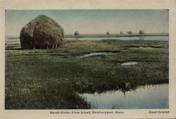
This postcard is of the haystacks on Newburyport’s Plum Island marsh, when they built the haystacks by hand and not by machine.

YMCA Newburyport, postcard

YMCA Newburyport, postcard

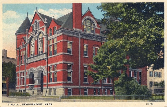
This is of Newburyport’s former YMCA on State Street that burnt down July 1987.  The YMCA was at the corner of State Street and Harris Street, where the expansion of our beautiful Newburyport Library exists today.  The YMCA was so decimated by the fire, that it was un-salvageable, eventually demolished, with a few of it’s elements incorporated into the MBTA train station in 1998.

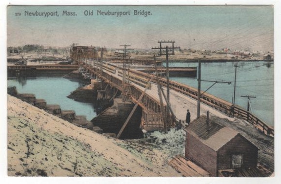
Old Newburyport Bridge, Postcard

Old Newburyport Bridge, Postcard

This is a post card of Newburyport’s old Bridge, before Rt 1 was built in the 1930s. It is a view from Water Street, downtown Newburyport, looking towards Rings Island, Salisbury, MA.

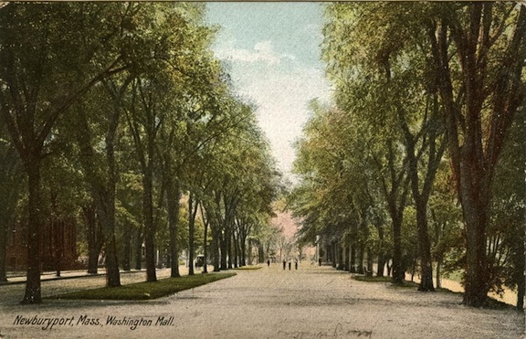
Newburyport Mall, postcard

Newburyport Mall, postcard

And this is the Bartlet Mall along High Street when the stately elm trees existed. The Court House is to the left, and High Street is to the right.

The Master Plan for the Bartlet Mall had been worked on for a very long time, by a whole lot of people, and was finally finished in 1998. Restoration of the Bartlet Mall took place in 2001, 2003 and 2005. The Bartlet Mall was restored to its original design and the avenue of elm trees was replanted so that one day the beautiful canopy of trees would exist once more..

Newburyport is now High End, it used to be a Slum

On December 7, 2007 I wrote on the Newburyport Blog, wondering if Newburyport was headed for “high-end.”

And seeing where Newburyport has come since then, even in a short amount of time, now in July 2015, the answer is definitely, “Yes.” And I’m guessing it’s going to get more and more “high end.”

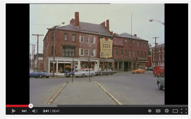
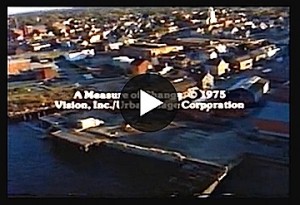
Market Square, downtown Newburyport, from the film “A Measure of Change” by Lawrence Rosenblum.

Newburyport, from the film "A Measure of Change" by Lawrence Rosenblum.

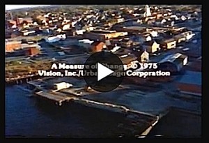
Newburyport, from the film “A Measure of Change” by Lawrence Rosenblum, press image to enlarge.

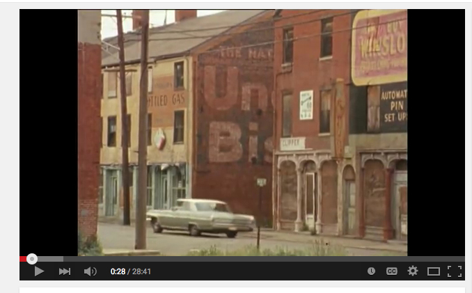
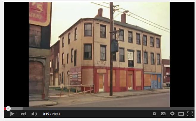
Downtown Newburyport, Water Street, from the film “A Measure of Change” by Lawrence Rosenblum.

Newburyport, from the film "A Measure of Change" by Lawrence Rosenblum.

Newburyport, from the film”A Measure of Change” by Lawrence Rosenblum, press image to enlarge.

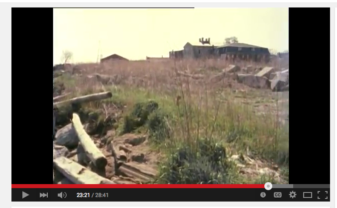
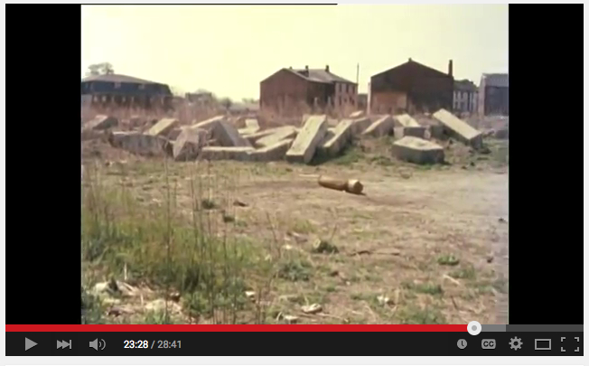
And this is where we as a city were back in 1970. Yes, Newburyport was a slum, it is really different now (vast understatement).

The film “A Measure of Change” was made in 1975 by Lawrence Rosenblum (it was uploaded with permission by Jerry Mullins over at Brick and Tree).  It is a film that chronicles the pivotal time (Urban Renewal) when the city transformed itself from a worn-out mill town (a slum) to a vibrant destination city by using historic preservation (first in the nation to use restoration rather than demolition for urban renewal). And Newburyport is now a prototype for other municipalities across the United States.

The photos in this post are still photos from the film. The link to the film “A Measure of Change” on YouTube can be found here.

Link to a Measure of Change

Link to a Measure of Change

Downtown Newburyport, Water Street, from the film “A Measure of Change” by Lawrence Rosenblum.

Newburyport, from the film "A Measure of Change" by Lawrence Rosenblum.

Newburyport, from the film “A Measure of Change” by Lawrence Rosenblum, press image to enlarge.

The Waterfront, downtown Newburyport, from the film “A Measure of Change” by Lawrence Rosenblum.

Newburyport, from  the film "A Measure of Change" by Lawrence Rosenblum.

Newburyport, from the film “A Measure of Change” by Lawrence Rosenblum, press image to enlarge.

The Waterfront, downtown Newburyport, from the film “A Measure of Change” by Lawrence Rosenblum.

Newburyport, from the film "A Measure of Change" by Lawrence Rosenblum.

From the film “A Measure of Change” by Lawrence Rosenblum, press image to enlarge

Newburyport, Proposed 40R Smart Growth Update

Here is a link to the application that the City of Newburyport made for the proposed 40R Smart Growth District (It has all kinds of links and information on it), it can be found here.

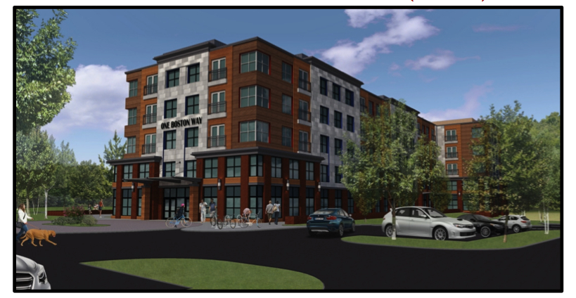
Here is a photo of the proposed Minco building (it is now in the public domain), which is the cornerstone of the proposed 40R District, and that I think is  ugly.

Minco Building

The Minco building

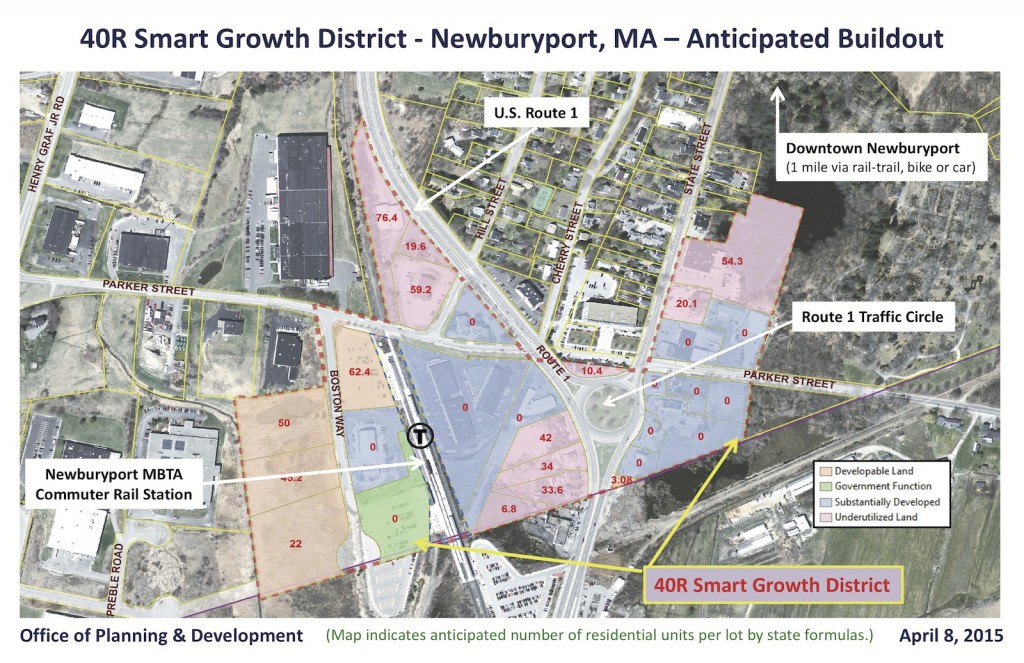
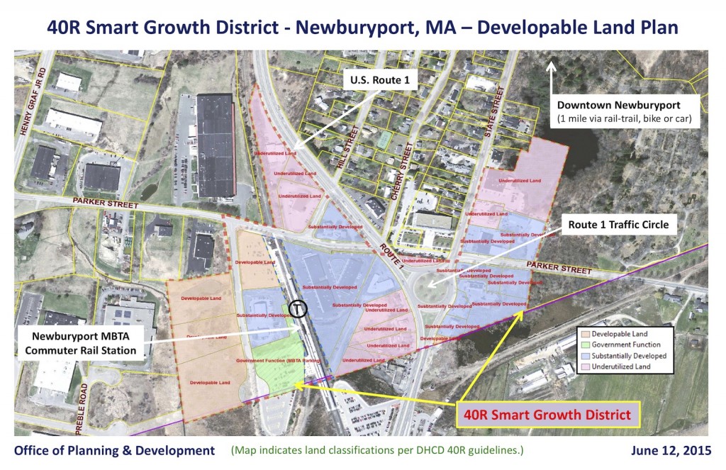
Here are two of the new maps of the proposed Smart Growth 40R

Smart Growth 40R map

40R Smart Growth map

Smart Growth 40R map

Smart Growth 40R map

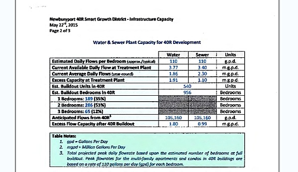
And here is a table for the Water and Sewer capacity for the 40R District which also includes the number of bedrooms and the number of apartment units.

Water and Sewer capacity and number of bedroom and units

Water and Sewer capacity and number of bedroom and units


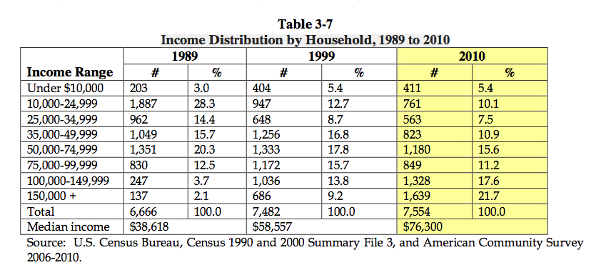
Newburyport’s 40R Smart Growth, Trying to Bring Back Rental Units to the City, and the Data from 1989 to 2010 of the Rising Income Gap

Income percentages in Newburyport from 1989-2010 from the City of Newburyport's website

Income percentages in Newburyport from 1989-2010 from the City of Newburyport’s website

It is really hard to find a place to rent in Newburyport these days. If you go to Zillow and look for rentals in Newburyport, it’s very depressing.  That is why the city is so hopeful about the proposed 40R, which is a real effort to bring back rental units back to Newburyport.

Here is a document from the city that articulates with data the gentrification that has taken place since Urban Renewal, especially interesting is the “Income Distribution by Household, 1989 to 2010″ on page 20 (an image of the table is in this post), that document can be read here.

In 1989 the largest percentage of income was $10,000-24,999. In 2010 the largest percentage is $150,000+, and that is in 2010, when we were still in the “great recession,” and I would think in 2015 that percentage would be much, much greater now.

And here is Jerry Mullins’, over at Brick and Tree, worst fears about what would happen to the proposed 40R. That post can be read here.

And here is a link to the discussion on The Newburyport Blog’s Facebook page, it can be read here.

Previous post on the proposed 40R District can be found here.

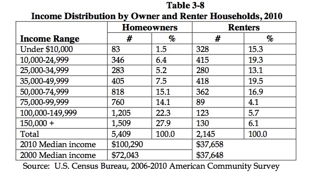
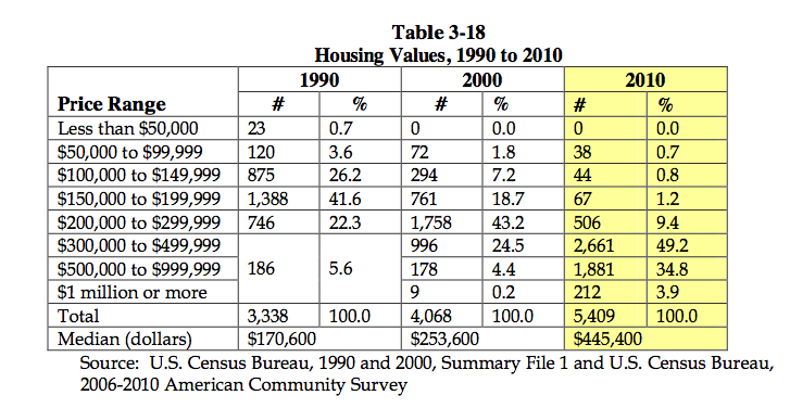
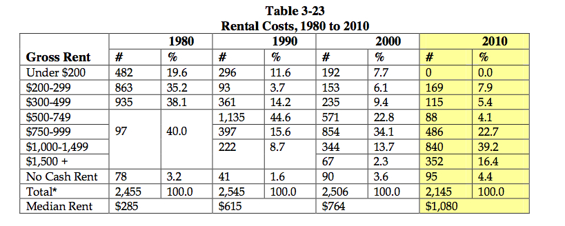
Here are some more table from the City of Newburyport’s report “Income Distribution by Household, 1989 to 2010.”

renters

Renters and Owners

Housing values

Housing values

Rental costs

Rental costs

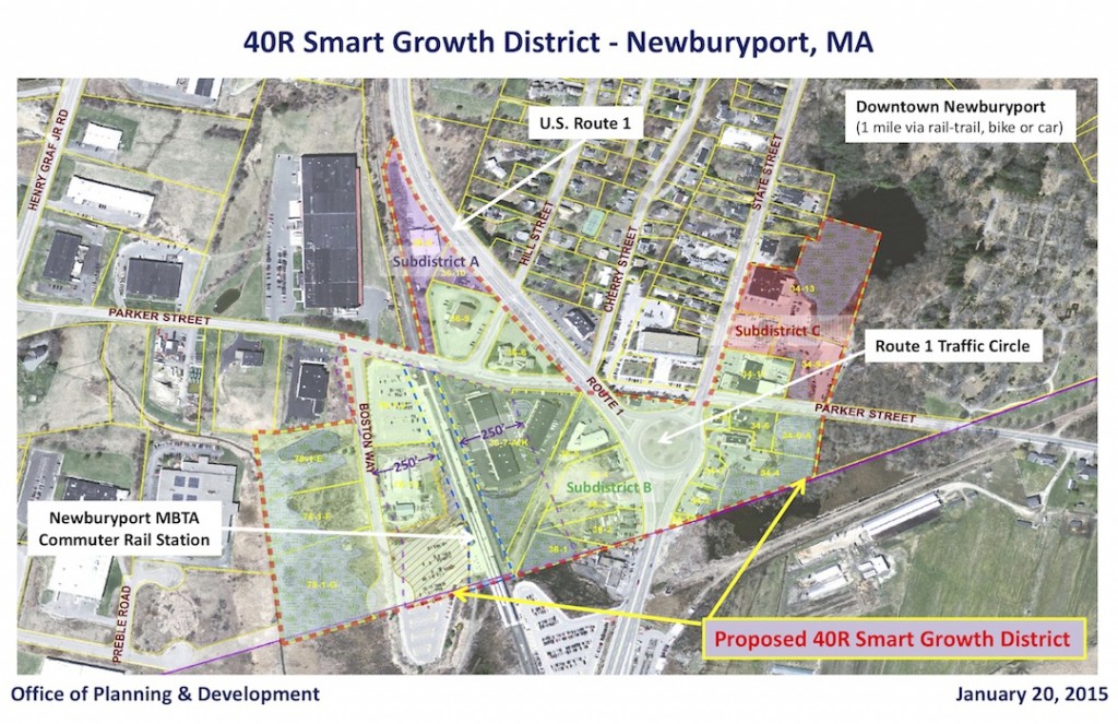
And here is a map of the proposed 40R Smart Growth District.

A map of Newburyport's proposed 40R District.

A map of Newburyport’s proposed 40R District.

Newburyport’s Proposed 40R and Highway Engineers

trafficLights

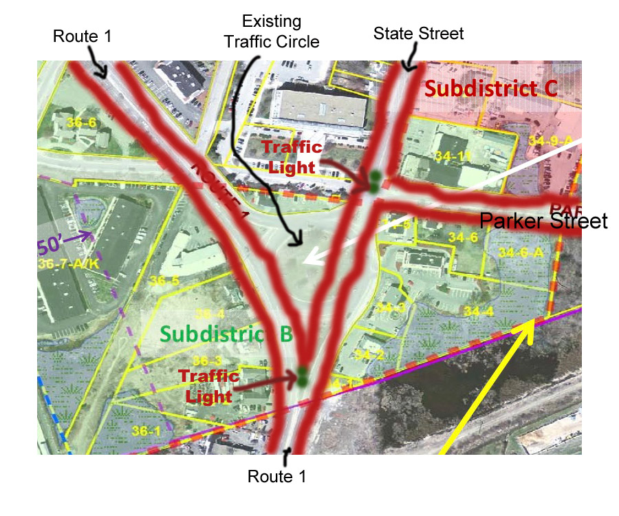
What highway engineers might propose for the traffic circle

This is one of the things that concerns me about the proposed 40R Smart Growth District around the traffic circle. Eventually the traffic circle will need to be refigured. I can imagine that highway engineers might recommend something like the drawing above. A light with turning lanes where Route 1 and State Street meet, and a light and turning lanes at State Street and Parker Street. No one would want this (I don’t think).

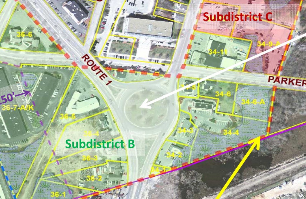
Existing traffic circle in the proposed 40R District, no guidelines for future development

Existing traffic circle in the proposed 40R District, no guidelines for future development

But, at the moment, in the present draft of the ordinance, there is no mention of what should happen to that very crucial area down the line. Who knows when that might happen, 2, 5, 20 years from now?  And who knows who will be mayor or who the planning director might be, or even if a project of this magnitude could span several administrations and planning directors.

Newburyport-40R-Smart-Growth-Village-District-Map-1-20-2015

Map of the proposed 40R distrist

It would depend who was in office, if they had the vision and the moxie (courage and determination) to negotiate with MassDOT (been there, seen the best and seen the worst).

So I think it would be a good idea to have some guidelines. I think that is fair.

The Proposed 40R Minco Building is Ugly

The Minco Building

The Minco building

Editor’s note: The Minco Building, the image, as of June 19, 2015, is now in the public domain.

Map of the proposed 40R District

Map of the proposed 40R District

I cannot put an image up of the proposed Minco building because of copyright issues, but you can see it if you press here. (Editor’s note, it is now included in the post because the image, as of June 19, 2015, is now in the public domain.)

The only place left to build in Newburyport is around the train station and the traffic circle.

For years (since 2004) Newburyport has been talking about creating a “40R smart growth” district, which, “encourages communities to create dense residential or mixed-use smart growth zoning districts, including a high percentage of affordable housing units, to be located near transit stations, in areas of concentrated development such as existing city and town centers, and in other highly suitable locations.”

All of this could be very, very good, if not great, BUT, we are creating a new gateway to the city. If the new zoning 40R passes, the Minco building behind the train station will be the first project. IT IS UGLY. And it is important that it not be ugly, because it will set the standard by which other structures that (probably would be built over a 20 year period) would refer to.

ALSO… the traffic circle eventually would be eliminated. There are no drawings, no plans, no nothing that would demonstrate what that might, could, should look like. It could be great, mediocre or awful.  At this point it seems that the sentiment is pass the 40R District so that the Minco building can get built, and just hope for the best.

There are NO drawing to show, if/when actually built, what the 40R district would look like (we only have the rendering of the ugly Minco building to go by).  This is not good. And whoever is responsible, needs to get their act together and come up with these two renderings, so that an intelligent and informed opinion can be made.

Previous posts on the proposed 40R District can be read here.

The draft of the proposed ordinance can be read here.

Newburyport, a Romantic City and the Proposed 40R District

I’ve been trying to pinpoint what it is about Newburyport that I love so much. What keeps me longing to stay here despite a winter like the one we’ve just had.

High Street, Newburyport,  photo courtesy of the Library of Congress

High Street, Newburyport, photo courtesy of the Library of Congress

Jerry Mullins in his blog post uses the word “romance” in connection to Newburyport, and it is an adjective that describes this small New England seacoast city north of Boston, that had never occurred to me, but it is a wonderful adjective. So I went on a hunt to see what showed up for “romanic cities.”

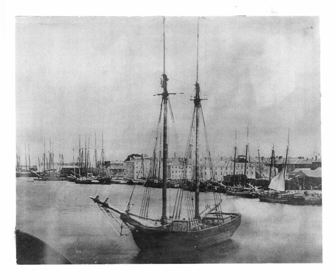
Newburyport's Waterfront, courtesy of the Archival Center at the Newburyport Public Library

Newburyport’s Waterfront, courtesy of the Archival Center at the Newburyport Public Library

And I found a blog post by Ken Benfield, a specialist on “smart growth and sprawl,” with this list:

  • Strong sense of place anchored by historic preservation
  • Lively, walkable, diverse downtowns
  • Compact development patterns
  • Extensive and well-used public transportation
  • Great public spaces for lively human interaction
  • Parks and quiet places mixed in with urbanity
  • Great traditional neighborhoods with a strong sense of community
  • Welcoming to people of diverse cultures

In the comment section of the blog post there was this observation:

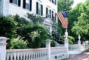
High Street, © Sally Chandler, 2004, Courtesy of "Historic Gardens of Newburyport"

High Street, © Sally Chandler, 2004, Courtesy of “Historic Gardens of Newburyport”

“Cities that are dense, walkable, have accessible and vibrant public spaces, and have a vibrant mix of independently-owned businesses are the most enjoyable places to visit – and to live. It is at the intersection of these features where real neighborhoods and a sense of livability is created. These cities are also strong, have committed populations and diverse economies, and can survive many challenges. In essence, they are not only beautiful and livable, they are resilient.”

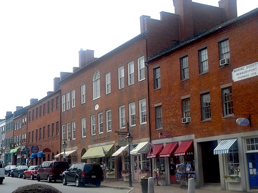
State Street, Newburyport, courtesy of Wikipedia

State Street, Newburyport, courtesy of Wikipedia

We as a city are considering making the area around the train station and the traffic circle into a 40R, Smart Growth area. I have many reservations about what is projected for that area, including the Minco Project in back of the train station (which I think is wicked ugly). And I think that Jerry has nailed the adjective for me. It may be (or not be) good urban planning, but what the vision lacks, is the “romance,” “beauty,” a “sense of place” that draws so many of us here to Newburyport.

The First Draft of the 40R District around the Train Station

I’ve seen the first draft of the new 40R Smart Growth District around the train station.

The proposed 40R District (see previous post) would allow for mixed use buildings near the train station, traffic circle, parts of Rt 1 and the area on lower State Street between Lunt and Kelly and the edge of the cemetery. There is a new updated map (see below), the larger area subdistrict B is zoned for 4 story buildings (45 ft), Subdistricts A and C is zoned for 3 story building (35 ft), and the Minco building would be zoned for 5 stories (55 ft).

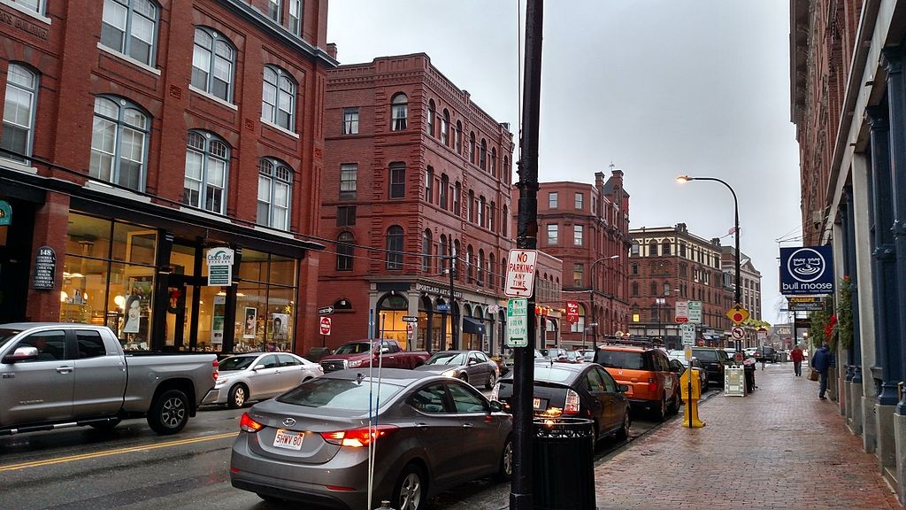
Portland-Wikipedia

Four story buildings in Portland Maine, please press image to enlarge.

And I’ve gone on a hunt for some good looking 4 story buildings. I have found only one photo that is in the public domain, it is in Portland Maine.

I’m a little confused about Google’s copyright laws, and WordPress does not allow me to embed Google’s images, so what I’ve done is put links to 4 story buildings in Portland ME, Providence RI and Haverhill MA. Haverhill has, on Washington Street, what I think is a gorgeous, but rundown historic section of 4 story building. I love them.

And when you press on the links for the different cities, you can go on a “Google drive” through the areas and see what you thinks works and what does not work. Interesting stuff. Also, the buildings take a few seconds to show up after you press the links.

Portland Maine’s links can he found here, here, here, here and here.
Providence Rhode Island’s links can be found here, here and here.
Haverhill Mass links can be found here, here and here.

Newburyport-40R-Smart-Growth-Village-District-Map-1-20-2015

Updated 40R Smart Growth Village District map, please press image to enlarge.

In looking at the initial 40R draft (this is just the beginning of a large process that the city will go through) a couple of things stand out.

1) The design review is outstanding. Yah!! I hope that means that the Minco building will be forced to look awesome.

2) There is extensive input into the affordable housing aspect of the district (I’m sure the affordable housing folks with Phd’s in the subject, will have lots of input). It looked great to me.

3) Parking seems a little “skimpy” to me. A residential unit only gets one parking spot. But there is “shared parking,” with businesses and residents, which use parking at different times during the day and week, the objective being not to have lots of wasted, barren parking lots. There are so many people in this city who have Phd’s in parking, and I am not one of them. I am hoping, and pretty sure that they would figure out the “Goldilocks” version of parking, “not too much, not too little, but just right.”

4) The setbacks of the buildings are puzzling to me. There are “no requirements” on setbacks on front, side and rear yards. The way it was explained to me is that there would be no requirements for setbacks for mid-block buildings, but it might be a good idea to look at the setback requirements for intersections (and there seem to me to be a whole lot of intersections). At this point, we do not have close-up renderings of what buildings would look like in different areas of the proposed 40R District.

This is one of my main questions. I can’t imagine 4 story building around the traffic circle where Dunkin’ Donuts is and where the Bird Watcher is located. I can’t imagine anyone wanting to live on that dangerous and noisy area, and being so close to a busy traffic circle. Renderings are definitely needed.

5) Not in the 1st draft, but backup information that would be arriving in the coming weeks that would include:

(1) estimated maximum dwelling units
(2) expected sewer flows (and how to pay for them)
(3) expected traffic impacts
(4) renderings/photo-simulations of new buildings
(5) expected impacts on schools
(6) expected c. 40R and c. 40S payments from the Commonwealth
(7) expected property tax revenues

Newburyport’s 40R District around the Train Station

Newburyport is beginning the process of thinking about rezoning the area around the train station, so that there can be a mix of residential units and businesses. This is called a 40R Smart Growth District. This is nothing new, the city has been talking about this since 2004.

“Chapter 40R, encourages communities to create dense residential or mixed-use smart growth zoning districts, including a high percentage of affordable housing units, to be located near transit stations, in areas of concentrated development such as existing city and town centers, and in other highly suitable locations.”

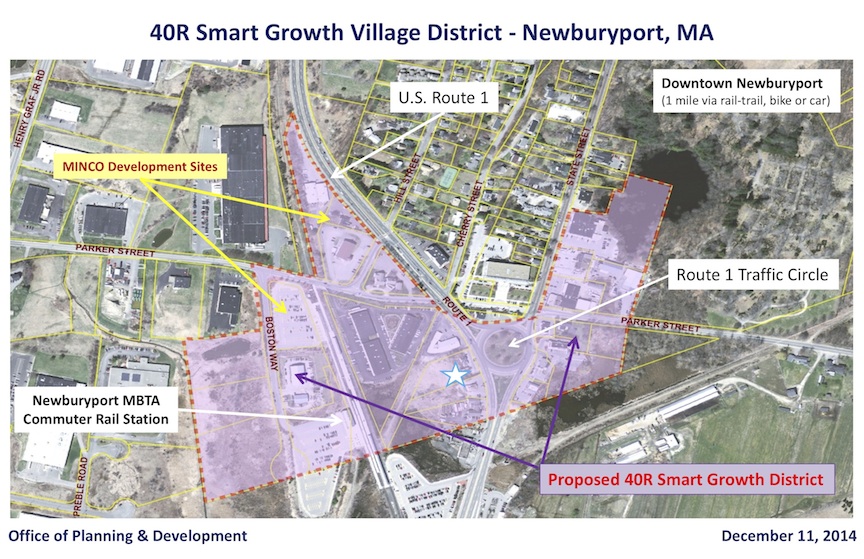
Here is a 2015 map of the proposed 40R District. It includes the area around Lunt and Kelly, where Dunkin’ Donuts is around the traffic circle, it goes up Rt 1 by Haley’s Ice Cream and includes the proposed building by Minco at the train station.
Newburyport-40R-Smart-Growth-Village-District-Map-12-11-2014-small

The 2015 map of the proposed 40R District (press image to enlarge)

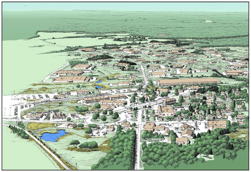
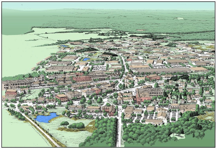
Here are the 2 conceptual drawing that were done in 2004 by the Planning Office. The view is from Parker Street coming from Newbury. The first rendering is the way it looks now, the second rendering, done in 2004 (we don’t have an update yet) is what the proposed 40R District might look like. It’s a little confusing, but if you download the two renderings and put them side by side it becomes a little clearer.
Strategic Land Use Plan-small

The 2004 rendering of how the area looks now (press image to enlarge)
Strategic Land Use Plan2-small

The 2004 rendering of what the 40R District could look like (press image to enlarge).

At the moment there is a certain “rush” to get this 40R District going, because Minco would like to build at the train station (this is nothing new, it has been going on for a while) and has a deadline (which may or may not be flexible). And the city gets money for a 40R District (we always need money).

BUT, I think that it is very important to ask hard questions during this process, and be sure to think things through.

So here are a few of my “hard” questions and concerns and reservations.

1) The Minco design at the train station has to look great. At the moment I haven’t talked to anyone who thinks that it is in anyway acceptable.

2) There needs to be a “design review” for that area. This gateway to the city can’t look awful.

3) Traffic. The maximum buildout, when last I heard was 800 units. Folks that I’ve talked to think that it would be a lot less, more like 500 units. We don’t know the exact numbers yet, but even 400-500 units is a lot.

The 2004 rendering of what the area would look like, seems idyllic to me. There are no cars. If that area were to be built out, at rush hour it would be a complete nightmare.

4) Pedestrian traffic. Even with the rail trail, there is no way to safely and or practically cross either the traffic circle or Route 1 to get downtown, even at the crossing at Rt1 at what is called “Back Bay.” People want to get from the area on foot and they want, and do try to get to State Street, which is insanely dangerous. I think at one point there was an idea for a pedestrian bridge, but, oh my, that would cost so much money.

5) I still can’t envision anyone wanting to live up along Rt1, even with the rail trail there. The view is butt ugly, with Rt1 on onside and a view of the Industrial Park on the other.

6) I also can’t imagine anyone wanting to live around the traffic circle, especially where Dunkin’ Donuts is located. The view towards Newbury as it is now, is lovely. However, I would think living next to a dangerous traffic circle would be unappealing, and figuring out a way to walk from there, much less having a denser number of people trying to exit at that location by car, raises the question of safety to me.

7) The area on State Street.  The intersection where the Court House, Parker Street, State Street and the Traffic Circle intersect is wicked dangerous. I’ve seen really bad accidents there. If that area becomes densely populated, that intersection becomes even more dangerous. And I don’t like the prospect of getting MassDOT involved–Salisbury Square is a cautionary tale for everyone, of what never to do, and of how MassDOT can really mess up an area.

So, I totally get building at the train station if it is done well. And I have a lot of questions about building in the other proposed areas. And I hope, that through this process we don’t ram this through because of Minco’s deadline, and the fact that we would like the money from the state.
Leading–the Best and the Worst of the Legislative Process, Newburyport 2014

CityOfNewburyport

This year, 2014, it is my opinion that Newburyport saw the best and the worst examples of the legislative process in the Newburyport City Council

THE BEST

The best was the attempt to preserve Newburyport’s historic assets.

The process had its origins in Newburyport’s raucous and rancorous LHD debate (see endless posts). The two sides as I now look back:

1) Preserving Newburyport’s historic assets through regulations governed by a particular commission.
2) A concern about the control of that commission, and a distrust of commissions like it in other communities.

I ended up thinking that both were valid points of view.

And then Newburyport City Councilor Katy Ives spent a good year and a half listening to all and sundry and came up with an incredible win-win solution.

1) The properties before 1930 in Newburyport’s Historic District could not be demolished.
2) Newburyport’s commercial downtown, our “brand,” needed to be preserved.

Katy Ives got elected to the Massachusetts State Senate, and the compromise by Senator Kathleen O’Connor Ives died. Poof.

That is until Jared Eigerman got elected as Ward 2’s City Councilor. And Councilor Eigerman met with the “Yes LHD” folks, the “No LHD” folks, hardcore preservationists, and hardcore property rights folks. It was made clear that no one was going to get everything they wanted, and that an ordinance would be presented that was possible in the existing political climate. It was basically what Senator Kathleen O’Connor Ives had proposed a year and a half before.
People may have not liked all of it, but it passed unanimously with an 11-0 vote.
And people, whether they liked all of it or not, did not:

1) Feel ignored
2) Feel invisible
3) Feel as if their insights were insignificant

People felt that a decision had been made that took into account a wide variety of feelings and thoughts about the issue.
The result = a whiff, or slightly more than a whiff, of trust and hope.

THE WORST

The worst legislative process in 2014 by the Newburyport City Council in my opinion was the Plastic Bag Ban.

For me this was the most frustrating and appalling legislative process that I have been involved in. During that process, all kinds of very productive points of view and ideas were presented. They were swept under the rug.

As a result people:

1) Felt ignored
2) Felt invisible
3) Felt as if their insights were insignificant

People felt that a decision had been made that did not take into account a wide variety of feelings and thoughts about the issue.

The measure passed with a split vote of 6-5 with 2 of the City Councilors who voted for the measure, expressing doubt and reservation on the Council floor.

The result = a huge lack of trust, a festering sore and lingering resentment, and discouragement (the opposite of hope) in a process that did not reflect the larger representation of the citizens of Newburyport.

Video about Newburyport’s Urban Renewal, “A Measure of Change”

Many thanks to Jerry Mullins over at Brick and Tree for putting this incredible video about what Newburyport used to look like up again, this time on YouTube.

Newburyport used to look like a slum.  Hard to believe, but the history on this video is amazing.

And there are a lot of friends on the video.  Sue Little, the owner of Jabberwocky Books, opens the video.  Tom Kolterjahn, the president of The Newburyport Preservation Trust is on there, along with Bryon Matthews, John (Hacky) Pramberg, Bill Harris, Jack Bradshaw.

Enjoy!

A Measure of Change, the video about Newburyport's Urban Renewal

A Measure of Change, the video about Newburyport’s Urban Renewal

The link to the video “A Measure of Change” can be found here.”

New Rules, Bricks on Curbs to be Replaced by Cement in Newburyport

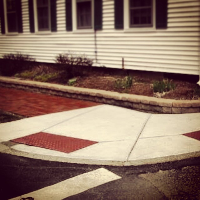
Example of new white curb cut next to a brick sidewalk.

Example of new white curb cut next to a brick sidewalk.

This is what I now know (please see legal disclaimer–I am an amateur blogger, not a legal expert, or highway engineer, or any of the other things one might want to be, to fully comprehend this, and yes, there are still a lot more questions).

In March of 2012 MassDOT mandated the following changes for ADA curb cuts (those are the cuts on sidewalk corners):

1) To have a “Detectable or tactile warning strip, consisting of truncated domes.” (i.e. bumpy things)

2) And the change is also in material, the requirement is that it be “slip resistant” which according to the description, eliminates brick:

“7. Walk surfaces shall be designed and constructed as firm, stable and slip resistant surfaces. They shall lie generally in a continuous plane with a minimum of surface warping.”

The document can be read here:

What this means in real simple terms, is that legally cement is now in, and brick is out.

I have confirmed this with a very, very nice person at MassDOT, as well as folks who know this stuff in Newburyport City Hall.

And this applies to historic cities and towns all over Massachusetts, including Boston. And from what I can make out (every place that I have checked), with the exception of Beacon Hill, has eventually given in and gone with cement over brick (with much wailing and gnashing of teeth) (again, I am an amateur blogger, not a professional journalist–disclaimer one more time).

On Monday night, at the Newburyport City Council Meeting, the list of streets and sidewalks to be repaved is on the agenda to be Ok’d by the City Council. My hope is that at least one member of the City Council will get up and say, “Wait a minute, could we Ok all the money for roadwork and sidewalks, but could we take a little bit of time to find out some answers to the curb cut–no more brick thing, before we give the big go ahead on that one.”

My hope is that if brick is out and cement is in, that maybe we could mitigate the visual impact in some way.  And I’m just throwing ideas out there, there is such a thing as stamped cement, that looks like brick.  I have no idea if that would work, but something along those sort of lines would be better than glaring white strips of cement that would eventually replace the brick corners that now exist.

Here is a list of corners that are slated to be redone this year, where brick would be an issue:

Along High Street:
State Street
Market Street
Federal Street
Lime Street
Parsons Street
Coffins Court
Allen Street
Bromfield Street
Barton Street

And:
State Street and Garden Street (Where the Dalton Club is.)

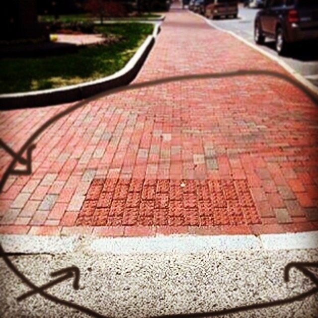
Brick-curbing

An an example of a good looking curb cut with brick that now exists. (The arrows pointing to the good example are photoshopped by me.)

EDITOR’S NOTE: A REPRIEVE!!  Newburyport City Councilor Bob  Cronin has just gotten up at the Newburyport City Council meeting and asked that the curb cuts that had been designated to be turned from brick to cement along High Street be sent to committee for further discussion. As I understand it, the matter was sent to “Public Safety.” (P.S. I wasn’t sure whether or not the now brick curb cut by the Dalton Club, at the corner of State and Garden was also included in that list.) Thank you so much Newburyport City Council!!

Newburyport’s Waterfront did have Buildings

Newburyport's Waterfront, courtesy of the Archival Center at the Newburyport Public Library

Newburyport’s Waterfront, courtesy of the Archival Center at the Newburyport Public Library

I’m sorry, I just can’t help myself.  I will read statements here and there from folks who desperately would like to keep Newburyport’s waterfront open, and the remarks go something like this, “Well, there never were any buildings on the Waterfront.”  Really, I hear this, sometimes, sometimes often.

Actually, that is not true. Not true at all.  And in this weeks Newburyport Daily News, John Macone wrote a fascinating history of the Waterfront, for Newburyport’s 250th anniversary.

Newburyport's Waterfront, courtesy of the Archival Center at the Newburyport Public Library

Newburyport’s Waterfront, courtesy of the Archival Center at the Newburyport Public Library

“This was a crowded, loud, dirty, busy, smelly, bawdy and in later years a somewhat dangerous place, thick with buildings perched on wharves that stretched far out into the Merrimack River. Vessels came and went from ports all over the world, and the riverside rang loud with the clang and bang of shipbuilding yards that lined the shore…”

The Waterfront c1920, courtesy of The Historical Society of Old Newbury

The Waterfront c1920, courtesy of The Historical Society of Old Newbury

And John Macone ends the piece by saying, “Newburyport’s great ship captains of the 18th and 19th century would find today’s central waterfront unrecognizable — too quiet, too neat, too big, and too open.”

You can read the entire article here, along with some fascinating photographs.

Newburyport Tells its Own Past

Photo courtesy of the Archival Center at The Newburyport Public Library

Market Square, Photo courtesy of the Archival Center at The Newburyport Public Library

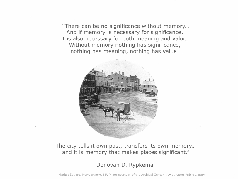
This is one of my favorite quotes. And I love this photo of Market Square, which is courtesy of the Archival Center at the Newburyport Public Library.

“There can be no significance without memory…And if memory is necessary for significance, it is also necessary for both meaning and value. Without memory nothing has significance, nothing has meaning, nothing has value…

The city tells it own past, transfers its own memory…and it is memory that makes places significant.”

Donovan D. Rypkema, writing about the historic buildings in Newburyport, Massachusett

New Archival Center Link for Historic Photos at The Newburyport Public Library

Historic Photograph

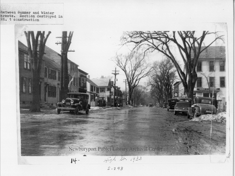
High Street at Summer and Winter Streets Courtesy of the Archival Center at The Newburyport Public Library

There is now a new link to the historic photographs at The Newburyport Public Library Archival Center.  It can be found here.  If you download the photograph please give the Archival Center credit.  Thank you.

(It is one of my pet peeves that people download photographs from The Newburyport Blog and repost them elsewhere, without saying where they come from.)

Perspective from Newburyport City Councilor Meghan Kinsey

I really appreciate the perspective from Newburyport City Councilor Meghan Kinsey that was expressed in an email to her constituents.

“I would fully agree with Councillor Cameron’s assertion that the Council (10 of the 11 were present) did not “balk”. Quite the contrary. We were intrigued and impressed by Councillor Eigerman’s ability of to remove much of what made the previous LHD proposals so unattractive to many and start new with a zoning change.”  …and “Let me start by saying that this community is quite fortunate to have Councillor Eigerman, and all the expertise he brings, on our council. As a land use attorney who is trained in city planning, we got a lot of “bang for our buck” in him.”  Councilor Kinsey points out that the three proposed ordinances “are heavy with legal-speak and we, as a council, are still trying to get our heads around them.”

Councilor Kinsey’s entire email can be read here.

The Jackals are Out – Newburyport Zoning

It didn’t take long. And yes, they are back.  The Say No to LHD Jackals are back.  Lyndi Lanphear, who got soundly defeated in November’s election for Newburyport City Council at Large, coming in second to last, is out with a Letter to the Editor in today’s Newburyport Daily News, that once again twists the facts, misrepresents the facts, and tries to scare the wits out of people by telling them stuff that is blatantly not true.

And Larry Cavalieri is in the cheering commenting section of the Newburyport Daily News, with comments that one can only think are meant to not only twist the facts, but intimidate people into not speaking up as well. “Vicious” and “foul,” are words, in my mind, that are not meant to be an “opinion,” but words that are meant to be invective.

And The Newburyport Daily News, btw, all sorts of anonymous commentators are also back.  Might want to clear that one up.

I can only hope that this Newburyport City Council can stay above the screaming fray, and come up with a good and equitable decision on Newburyport City Councilor Jared Eigerman’s three detailed and thoughtful zoning proposals.

And if you would like the correct information please press here.

Update:  Lyndi Lanphear has organized a meeting this Saturday to try and stop the zoning proposals from ever happening. Newburyport City Councilor Jared Eigerman has offered to explain to the people at that meeting what the zoning amendments are actually about, and what they hope to accomplish (zoning is complicated).  It is my understanding that Mrs. Lanphear has not taken Councilor Eigerman up on his charitable offer. It is my opinion that Lyndi Lanphear would rather confuse, obfuscate and frighten people with fictitious statements, than acknowledge the facts, and make constructive and helpful observations, the way Dick Hordon, the chair of the Say No to LHD group, who Councilor Eigerman sat down with, already has.

Zoning Overlay NOT a Local Historic District (LHD)

Unfortunately the Newburyport Daily News has repeatedly reported that a Local Historic District (LHD) is being proposed.  This is NOT the case, there is NO LHD period.  I am extremely disappointed in our paper of record.  I feel that it is the paper’s responsibility to inform and educate people, not to scare them. To me saying that this proposal is a LHD is like shouting “Fire” in a crowded room, when there is no fire, for me this is unfortunate and irresponsible journalism.  I expect more from the Newburyport Daily News.

Newburyport City Councilor Ed Cameron has clarified what is being proposed in the comment section of the latest Newburyport Daily News article on the subject.  Here it is:

Several clarifications to this reporting are necessary:

First of all this is not a single proposal by Councillor (Jared) Eigerman. He has submitted three separate zoning ordinance changes. Although they can be seen as related, they are each separate.

The three are:

1) a proposal establishing an Interim Downtown Overlay District is zoning that would preserve our historic downtown. Currently there are zero protections since the deed restrictions related to the HUD rehab of downtown which were in effect from 1971-2005 have lapsed. The Planning Board which oversees downtown site plan review would be the Special Permit Granting Authority.

Please note that Councillor Eigerman’s submitted change for downtown zoning is not a local historic district. A local historic district is created under Massachusetts Gen. Laws Chapter 40 C. What is proposed is a zoning change, not a local historic district, and is covered by Massachusetts Gen. Laws Chapter 40A. In this proposal, the local Historic Commission is not involved.

2) a proposal establishing an Interim Demolition Control Overlay District is zoning which would establish protections regarding teardowns in the Federal Newburyport Historic District established in 1984. The ZBA would be the Special Permit Granting Authority in these cases.

3 ) a proposal to amend our off-street parking regulations so that developers who are making a use change or building a new development and want to use public parking to meet their parking requirements will have to pay for it.

Please note that the Council Planning and Development Committee and Committee of the Whole did not “balk” at approving these zoning changes last night. The process is that these zoning changes will go to a Joint Public Hearing of the Planning Board and the Council’s Planning and Development Committee, an opportunity for the public to give input. Any zoning change in Newburyport must go through this process before the City Council takes action. That meeting has been advertised in the Daily News and will occur on Wednesday, February 19 at 7 PM at City Hall.

More details are here:

Councillor Ed Cameron”

Editor’s Note:  This is a comment  from John Macone, the Editor of the Newburyport Daily News, in the comment sections in the latest article in the Newburyport Daily News.  I appreciate it a lot.

” Thank you for your comments. I agree with commenters who have said this is not a true local historic district proposal, as set down in state law. However, it is also clear that these zoning amendments seek to achieve some of the same protections/property restrictions that the LHD contained.

I’ve changed the headline to better reflect the intent of Councilor Eigerman’s proposals. Also, we will be following up shortly with a comprehensive explanation of the similarities and differences between these proposals and the LHD proposal.
John Macone, editor”

The headline was changed to: “Historic Protections Proposed for Downtown.”

The Story of the Newburyport Turnpike, Rt 1, with Thanks to Gordon Harris

newburyport_turnpike

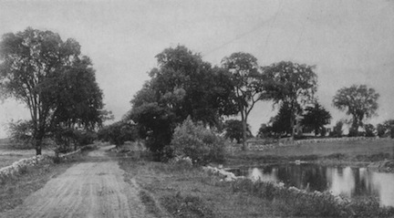
The Newburyport Turnpike, courtesy of Gordon Harris, originally from Massachusetts Beautiful, by Wallace Nutting, 1923

I’ve discovered a wonderful new (to me) blog, written by Gordon Harris of Ipswich, Massachusetts. The blog is called “Stories from Ipswich.” And I discovered it via Facebook.  Mr Harris has written the story of the Newburyport Turnpike or what we now call Route 1, and how it came to pass.

In 1803 a group of Newburyport investors incorporated as the Newburyport Turnpike Corporation in a commercial venture to build a straight toll road from Boston to Newburyport (the highway we call Rt. 1). The intent was to bypass Salem and promote Newburyport as a commercial destination. Proponents claimed it would cut travel time by a third compared to the old Bay Road (Rt. 1A).”

To read the entire fascinating account/history, please press here.

And many thanks to Gordon Harris for letting me borrow/steal the photo of the Turnpike for this post. To see a large version, please read his blog post.  And if you download the photo, please give Gordon Harris and his blog credit (it is now one of my pet peeves that I find images that have been collected by me, the editor of The Newburyport Blog, for the last 7 years, all over Facebook, without any credit to The Newburyport Blog or the place where the image originated).

New Newburyport City Council Committees

The Newburyport City Council has very important committees where the difficult work of the City Council gets done. The president of the Newburyport City Council appoints the people on the committees.  For 2014 the Newburyport City Council committees are as follows:

Budget and Finance:
Chair-Charles Tontar, Ed Cameron, Robert Cronin

Planning and Development:
Chair-Ed Cameron, Barry Connell, Jared Eigerman

Neighborhoods and City Services:
Chair-Barry Connell, Ari Herzog, Meghan Kinsey

License and Permits:
Chair-Allison Heartquist, Bruce Vogel, Meghan Kinsey

Joint Education:
Chair-Meghan Kinsey, Allison Heartquist, Larry Giunta

Public Utilities:
Chair-Ari Herzog, Jared Eigerman, Bruce Vogel.

Public Safety:
Chair-Robert Cronin, Larry Giunta, Charles Tontar

General Government:
Tom O’Brien, Bruce Vogel, Mayor Donna Holaday

Rules:
Chair-Robert Cronin, Larry Giunta, Tom O’Brien