I don’t know who wrote the editorial in the Newburyport Daily News, Wednesday, July 5, 2006, but let me tell you I was offended.
The editorial was talking about the possible acquisition of 126 acres between Hale Street and Scotland Road, along Route 95, that is owned by Arturo Gutierrez, if purchased by the City of Newburport it would be called “Wet Meadows.”
The editorial seemed to say, enough with the open space, let’s concentrate on affordable housing (this of course is a very rough paraphrase.)
Of course I’m for a whole lot more affordable housing in Newburyport, Massachusetts, who is not. And good people are working on making that goal a reality.
But, the Open Space folks have been working on open space really, really hard and they deserve a whole lot of credit. And to quote Mayor John Moak in the Newburyport Daily News, June 27, 2006:
“It seems like a good space to buy. It’s not a priority of mine, but its timeliness and availability means it has merit to it.”
Good for Mr. Moak. He’s right, the land is available and it has merit for all kinds of reasons, the subject of which could be a whole variety of posts in itself.
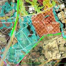
But since a picture is worth a 1000 words, I’ve put up a map showing the parcels that are owned by Mr.Gutierrez. They are kind of hard to make out. Mr. Gutierrez owns 3 large parcels and they are in a bright turquoise color on the map and they have his name on them.
The map is courtesy of www.ceport.org. I downloaded the map, I didn’t tell them, but I thought that they would not mind. You can see a bigger and much better version on their website under “Common Pasture.”
In the “Common Pasture” section look under maps and try: “Newburyport parcels and GIS Layers with Vernal Pools.”
The “Newburyport parcels with SLUC Baseline Report Map 9 and GIS layers Document” will download, and that is the one I used.
I’d definitely go and take a look.

Map Showing Wet Meadows
Mary Eaton, Newburyport