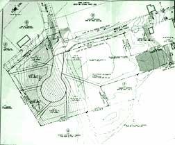
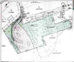
I went down to the Newburyport Planning Office and took pictures of the two plans that were submitted to the Newburyport Planning Board by the developers Todd Smith and Peter Nordblom of Willis Lane LLC. The plans are for the back part of the Wheelwright property that abuts historic Oak Hill Cemetery.
The proposed Wheelwright subdivision project is being called “Brown Street.”
There is also a memo from the consultant who is helping out the Newburyport Planning Office, former Newburyport Planning Director, Nancy Colbert (a great person.)
I would need the help of a pro for me understand what it all means. The gist of the memo appears to be, “there are a lot of problems with this Preliminary Application, folks.”
I did understand: “ The proposed cul de sac does not appear to comply with subdivision regulations.”
There seems to be some concern with the steep slope of the land (and the land is very steep.) From the same memo: “For the Board’s information, many communities prohibit development on steep slopes and do not allow the inclusion of steeply sloping land to be part of lot area calculations.”
Here are the two maps.
The first is the traditional subdivision map (this does seems unlikely to me.)

Traditional subdivision map for Wheelwright Property
The second is the OSRD or Cluster Zoning version. Things are real close to historic Oak Hill Cemetery. And there appears to be retaining walls along part of the proposed road.

OSRD subdivision map for Wheelwright Property
Mary Eaton
Newburyport