The Newburyport Daily News on Monday October 9, 2006 ran a cartoon by Gary Robertson (no, not our City Councilor Gary Roberts) on what is being proposed for the back of the Wheelwright property by Todd Smith and Peter Nordblom of Willis Lane LLC, or what is now being referred to by the developers as “Brown Street.”
The cartoon has a bunch of construction folks with chainsaws hacking down trees to make way for the development by Willis Lane LLC. There is a sign that says:
“COMING SOON
to this Historic Property…
Wheelwright Estates
FIVE –count’em – 5 Luxury Homes
Priced from…must you ask?”
And then there is a gentleman standing inside the Oak Hill Cemetery gateway saying:
“Hey! Are you the same guys that tried to build a strip Mall right next to Gettysburg?”
Gotta love it!
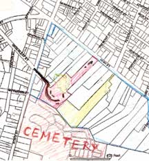
I have traced/drawn from the Newburyport GIS map part of the back of High Street, from State Street to Lime Street or what is know as the “Ridge” the land behind the stately High Street mansions. The tracing/drawing is pretty crude, but I hope it will give folks an idea of just how much land is back there.

The area in red is the Wheelwright Property that is being developed by Willis Lane LLC. Two little dark blobs near High Street are where the Wheelwright House, the historic gardens and the Carriage House would be. (The Wheelwright House is very large, so that gives some idea of how huge the property actually is)
The little green squiggly part is the “wet-lands” in the middle of the property. And then the brown line starts at what is Brown Street, and my freehand drawing of the extended road would give an idea of what the developers have proposed for the road in the ORSD or Cluster Zone subdivision.
(See previous post for the actual plans.)
It sure looks to me as if that whole area by the historic Oak Hill Cemetery would be decimated. And the neighbors are beginning to organize, handing out flyers and circulating a petition. That’s a relief.
The green area belongs to 67 High Street and that area has a deed restriction on it by the owner. That land bordering Oak Hill Cemetery can never be built on. Well, yeh, whew…thank goodness.
I’ve outlined the Ridge area in blue. (Again, a little crudely drawn, but the hope is to get the general picture.) This as far as I know, except for 67 High Street, is completely unprotected. (Please see Disclaimer on the “Overview, Guidelines and Information” page.)
As I understand it, there are things that the owners can do, like putting deed restrictions on the property, or possibly the City of Newburyport could do a protective overlay, I don’t know.
Who would have thought that a beautiful piece of property like the Wheelwright land would be proposed for a subdivision, of all things. I hope that the residents and the City of Newburyport could do something to protect the rest of this irreplaceable landscape.
Mary Eaton
Newburyport